

Datasets
-
MODIS/Terra Vegetation Indices 16-Day L3 Global 250m SIN Grid V061
The Terra Moderate Resolution Imaging Spectroradiometer (MODIS) Vegetation Indices (MOD13Q1) Version 6.1 data are generated every 16 days at 250 meter (m) spatial resolution as... -
MODIS/Terra+Aqua Nadir BRDF-Adjusted Reflectance Daily L3 Global 500 m SIN Grid
The MODIS Near Real Time (NRT) Combined Aqua and Terra Nadir BRDF-Adjusted Reflectance, MCD43A4N, Nadir Bidirectional Reflectance Distribution Function (BRDF)-Adjusted... -
OCO-3 Level 2 CO2 prior based on CO2 monthly flask record, global meteorology, and age of air, Forward Processing V10 (OCO3_L2_CO2Prior) at GES DISC
Version 10 is the current version of the data set. Older versions will no longer be available and are superseded by Version 10. The Orbiting Carbon Observatory -3 (OCO-3) was... -
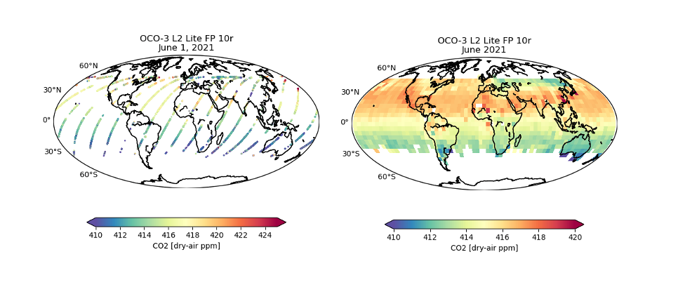
OCO-3 Level 2 bias-corrected XCO2 and other select fields from the full-physics retrieval aggregated as daily files, Retrospective processing V11r (OCO3_L2_Lite_FP) at GES DISC
Version 11r is the current version of the data set. Older versions will no longer be available and are superseded by Version 11r. The Orbiting Carbon Observatory -3 (OCO-3) was... -
S-MODE L2 Position Data from Surface Drifters Version 1
This dataset contains in-situ position data from surface drifters from the Sub-Mesoscale Ocean Dynamics Experiment (S-MODE) conducted approximately 300 km offshore of San... -
Sentinel-5P TROPOMI Near-Real-Time (NRT) Total Ozone Column 1-Orbit L2 5.5km x 3.5km V2 (S5P_L2__O3_TOT_HiR_NRT) at GES DISC
The Sentinel-5P TROPOMI Near Real Time (NRT) Total Ozone Column 1-Orbit L2 5.5km x 3.5km V2 (S5P_L2__O3_TOT_HiR_NRT) at GES DISC is the near real time version of the offline... -
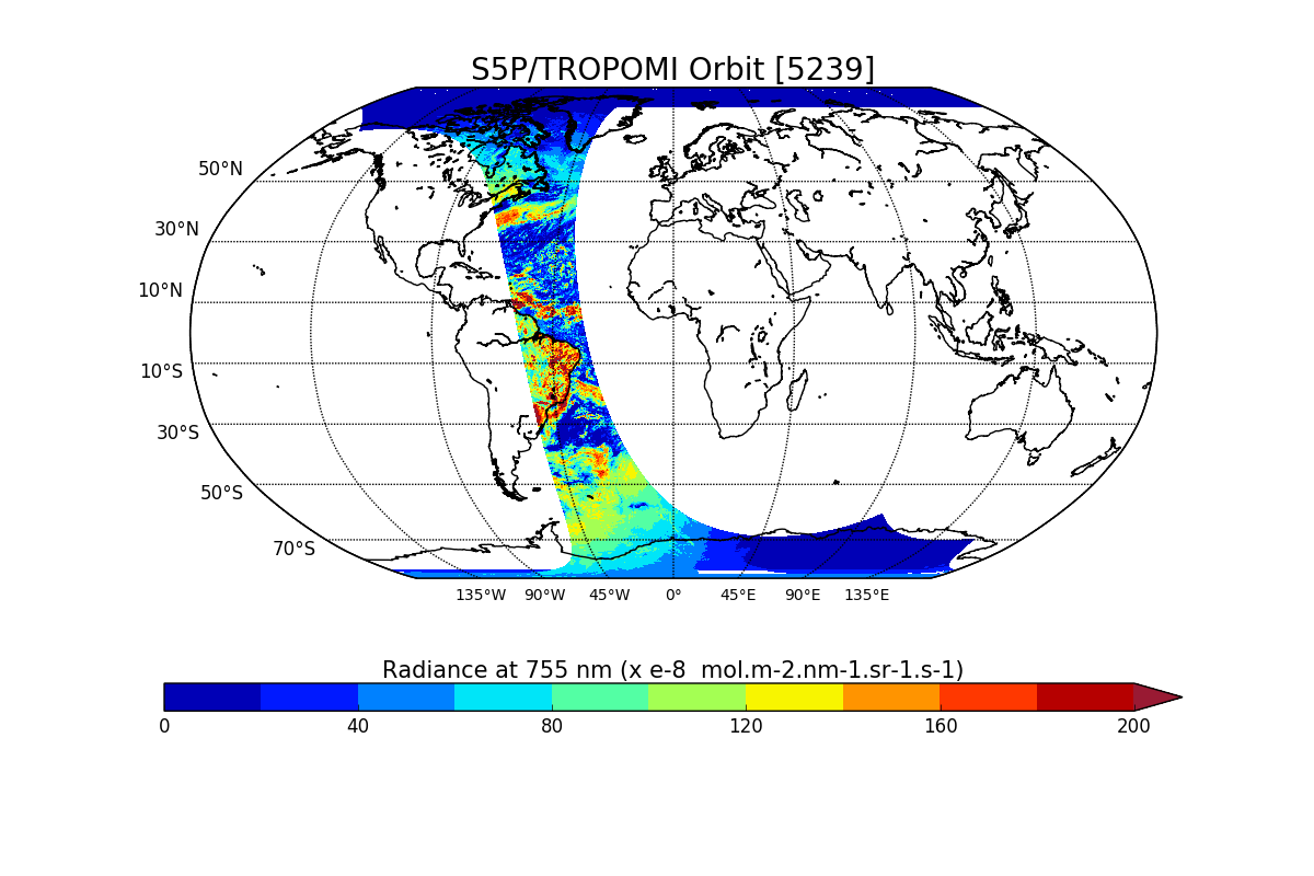
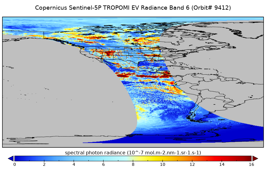
Sentinel-5P TROPOMI Radiance product band 6 (NIR detector) L1B V1 (S5P_L1B_RA_BD6) at GES DISC
Starting from August 6th in 2019, Sentinel-5P TROPOMI along-track high spatial resolution (~5.5km at nadir) has been implemented. For data after August 6th of 2019, please check... -
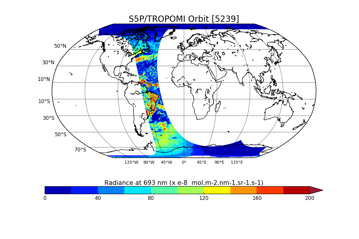
Sentinel-5P TROPOMI Radiance product band 5 (NIR detector) L1B V1 (S5P_L1B_RA_BD5) at GES DISC
Starting from August 6th in 2019, Sentinel-5P TROPOMI along-track high spatial resolution (~5.5km at nadir) has been implemented. For data after August 6th of 2019, please check... -
Sentinel-5P TROPOMI Radiance product band 4 (UVIS detector) L1B 5.5km x 3.5km V1 (S5P_L1B_RA_BD4_HiR) at GES DISC
Starting from August 6th in 2019, Sentinel-5P TROPOMI along-track high spatial resolution (~5.5km at nadir) has been implemented. For data before August 6th of 2019, please... -
Sentinel-5P TROPOMI Radiance product band 6 (NIR detector) L1B 5.5km x 3.5km V1 (S5P_L1B_RA_BD6_HiR) at GES DISC
Starting from August 6th in 2019, Sentinel-5P TROPOMI along-track high spatial resolution (~5.5km at nadir) has been implemented. For data before August 6th of 2019, please... -
Tellus Level-4 Greenland Mass Anomaly Time Series from JPL GRACE/GRACE-FO Mascon CRI Filtered Release 06.3 version 04
This dataset is a time series of mass variability averaged over all of the global ocean. It provides the non-steric or mass only sea level changes over time. The mass... -
TRACE-P P-3B Trajectory Data
TRACE-P_Trajectory_P3B_Data is the trajectory data collected onboard the P-3B aircraft during the Transport and Chemical Evolution over the Pacific (TRACE-P) suborbital... -
TROPESS Chemical Reanalysis Surface Anthropogenic CO emissions Monthly 2-dimensional Product V1 (TRPSCRECOAM2D) at GES DISC
The TROPESS Chemical Reanalysis Surface Anthropogenic CO emissions Monthly 2-dimensional Product contains carbon monoxide emissions from anthropogenic sources. The data are part... -
West Atlantic Pre-SWOT Level-4 Hourly MITgcm LLC4320 Native Grid 2km Oceanographic Dataset Version 1.0
This dataset provides a regional multivariate oceanographic state estimate from a global ocean numerical simulation with a focus on the West Atlantic region. The global ocean... -
Western North American FLEXPART Back Trajectory 2000 Data
WNA-FLEXPART-BackTraj-2000 is the 2000 Western North America Back Trajectory data using the FLEXible PARTicle (FLEXPART) dispersion model. Data collection for this product is... -
Fundamental Hyperelastic Material Study Project
This research is part of an innovative effort to use hyperelastic materials to produce flexible and seamless aircraft structures that reduce drag and minimize acoustic... -
North American Landscape Characterization
The North American Landscape Characterization (NALC) project is a component of the Landsat Pathfinder Program, which is part of a larger Pathfinder Program initiated by the...