

Datasets
-
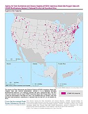
ATSDR Hazardous Waste Site Polygon Data with CIESIN Modifications, Version 2
The Agency for Toxic Substances and Disease Registry (ATSDR) Hazardous Waste Site Polygon Data with CIESIN Modifications, Version 2 is a database providing georeferenced data... -
SnowEx21 Cameron Pass Ground Penetrating Radar V001
This data set contains the results of 1 GHz ground-penetrating radar surveys conducted at Cameron Pass, Colorado during the SnowEx21 campaign. Data include two-way travel time,... -
MODIS/Terra Snow Cover Daily L3 Global 0.05Deg CMG V061 NGDA
This global Level-3 (L3) data set provides the percentage of snow-covered land and cloud-covered land observed daily, within 0.05° (approx. 5 km) MODIS Climate Modeling Grid... -
CALIPSO Lidar L1B Profile Data V2-02
Cloud-Aerosol Lidar and Infrared Pathfinder Satellite Observations (CALIPSO) was launched on April 28, 2006 to study the impact of clouds and aerosols on the Earth’s radiation... -
Gateway to Astronaut Photography of Earth
Planetary nomenclature, like terrestrial nomenclature, is used to uniquely identify a feature on the surface of a planet or satellite so that the feature can be easily located,... -
ROSETTA-ORBITER 67P ROSINA 2 ESC2 V1.0
This data set contains science data acquired by the COPS, DFMS and RTOF ROSINA sensors between 2015-03-11 and 2015-06-30 during the Escort phase 2 of the Rosetta mission at the... -
CALIPSO Wide Field Camera (WFC) L1B Science 1 km Registered Science Data V3-01
Cloud-Aerosol Lidar and Infrared Pathfinder Satellite Observations (CALIPSO) was launched on April 28, 2006 to study the impact of clouds and aerosols on the Earth’s radiation... -
PDS Data Dictionary (1r86)
PDS Data Dictionary and Index Files (1r86) -
OrbView-2 SeaWiFS Global Mapped Photosynthetically Available Radiation (PAR) Data, version R2022.0
The SeaWiFS instrument was launched by Orbital Sciences Corporation on the OrbView-2 (a.k.a. SeaStar) satellite in August 1997, and collected data from September 1997 until the... -
ULYSSES JUPITER HISCALE LEMS 120 ION COUNTS
This data set consists of HISCALE Low-Energy Magnetic Spectrometer (LEFS) ion counts at 120 degrees from the spacecraft spin axis. These measurements were taken during the... -
MPFL MARS ATM STRUCT INST AND MET PKG CALIB SURFACE V1.0
Mars Pathfinder bounced down and rolled to a stop on the surface of Mars on July 4, 1997. It landed in an ancient floodplain in the Ares Vallis region of Chryse Planitia at... -
Low Elevation Coastal Zone (LECZ) Global Delta Urban-Rural Population and Land Area Estimates, Version 1
The Low Elevation Coastal Zone (LECZ) Global Delta Urban-Rural Population and Land Area Estimates, Version 1 data set provides country-level estimates of urban, quasi-urban,... -
LOWELL OBSERVATORY COMETARY DATABASE - PRODUCTION RATES
20 Oct 2008, A.C.Raugh AddedThis dataset presents several data tables from A'Hearn et al. (1995) [AHEARNETAL1995], which contain a comparative analysis of Haser model production... -
ODYSSEY MARS MARIE REFORMATTED RAW DATA V1.0
The MARIE (Martian Radiation Environment Experiment), aboard the 2001 Mars Odyssey spacecraft, was launched on April 7, 2001, and arrived at Mars on October 24, 2001. Data were... -
CASSINI RSS RAW DATA SET - DIGR1 V1.0
The Cassini Radio Science Dione Gravity Experiment (DIGR1) Raw Data Archive is a time-ordered collection of radio science raw data acquired on October 10, 11, 12, 2005 during... -
SnowEx23 Snow Water Equivalent V001
This data set presents snow depth, snow water equivalent (SWE), and bulk snow density data collected during the NASA SnowEx 2023 field campaign between March 13-16 2023. Samples... -
Global Earthquake Hazard Frequency and Distribution
The Global Earthquake Hazard Frequency and Distribution is a 2.5 minute grid utilizing Advanced National Seismic System (ANSS) Earthquake Catalog data of actual earthquake... -
GALILEO ORBITER A POS IDA FLYBY TRAJ V1.0
Galileo Orbiter 60 second sampled trajectory data from the Ida flyby in Ida-centric Solar Ecliptic (ISE) and RTN coordinates. These data cover the interval 1993-08-28 00:00 to... -
Gazetteer of Planetary Nomenclature
Planetary nomenclature, like terrestrial nomenclature, is used to uniquely identify a feature on the surface of a planet or satellite so that the feature can be easily located,...