

Datasets
-
Planning to Explore: Using a Coordinated Multisource Infrastructure to Overcome Present and Future Space Flight Planning Challenges
Few human endeavors present as much of a planning and scheduling challenge as space flight, particularly manned space flight. Just on the operational side of it, efforts of... -
OCO-3 Level 2 spatially ordered geolocated retrievals screened using the IMAP-DOAS Preprocessor (IDP), Forward Processing V10 (OCO3_L2_IMAPDOAS) at GES DISC
Version 10 is the current version of the data set. Older versions will no longer be available and are superseded by Version 10. The Orbiting Carbon Observatory -3 (OCO-3) was... -
GOES-R Geostationary Lightning Mapper (GLM) Gridded Data Products V1
The GOES-R Geostationary Lightning Mapper (GLM) Gridded Data Products consist of full disk extent gridded lightning flash data collected by the Geostationary Lightning Mapper... -
TRMM Ground Validation Radar Site Rain Type Map L2 1 hour 2 km V7 (TRMM_2A54UW) at GES DISC
This dataset is part of the University of Washington TRMM Ground Validation products. Instantaneous convective-stratiform cartesian grid based on baseUW. Values are 0 (no echo),... -
GPM GROUND VALIDATION ENVIRONMENT CANADA (EC) MANUAL PRECIPITATION MEASUREMENTS GCPEX V1
The GPM Ground Validation Environment Canada (EC) Manual Precipitation Measurements GCPEx dataset was collected during the GPM Cold-season Precipitation Experiment (GCPEx) in... -
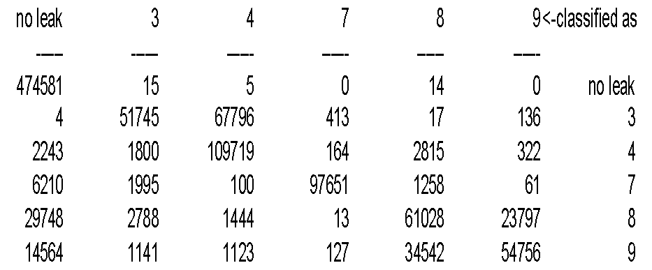
Learning to Improve Earth Observation Flight Planning
This paper describes a method and system for integrating machine learning with planning and data visualization for the management of mobile sensors for Earth science... -
Suomi-NPP VIIRS Level-2 Regional 11µm Day/Night Sea Surface Temperature (SST) - Near Real-time (NRT) Data, version R2016.2
The Ocean Biology DAAC produces near real-time (quicklook) products using the best-available combination of ancillary data from meteorological and ozone data. As such, the... -
Gazetteer of Planetary Nomenclature: Saturnian System: Mimas
These images display several of Saturn's moons approved by the International Astronomical Union (IAU). -
Flight Data For Tail 678
The following zip files contain individual flight recorded data in Matlab file format. There are 186 parameters each with a data structure that contains the following: -sensor... -
ARC Code TI: NodeMon
NodeMon is a resource utilization monitor tailored to the Altix architecture, but is applicable to any Linux system or cluster. It allows distributed resource monitoring via the... -
Gazetteer of Planetary Nomenclature: Asteroids: Lutetia Features
These images display asteriods documented and approved by the International Astronomical Union (IAU). -
TOVS GLA MONTHLY GRIDS from NOAA-12 V01 (TOVSAMND) at GES DISC
This dataset (TOVSAMND) contains the TIROS Operational Vertical Sounder (TOVS) level 3 geophysical parameters derived using data from NOAA-12 and the physical retrieval method... -
MER 1 MARS PANORAMIC CAMERA SOLAR RDR OPS V1.0
not applicable -
Terra MODIS Global Binned Particulate Inorganic Carbon (PIC) - Near Real Time (NRT) Data, version R2022.0 NGDA
The Ocean Biology DAAC produces near real-time (quicklook) products using the best-available combination of ancillary data from meteorological and ozone data. As such, the... -
MODIS/Aqua Calibrated Radiances 250m 5-Min L1B Narrow Swath Subset along CloudSat V002 (MAC02QS0) at GES DISC NGDA
This is the narrow-swath MODIS/Aqua subset along CloudSat field of view track. The goal of the narrow-swath subset is to select and return MODIS data that are within +-5 km...