
-
NOAA/WDS Paleoclimatology - Ras Umm Sidd, Egypt 245 Year Winter Coral Oxygen Isotope Data
This archived Paleoclimatology Study is available from the NOAA National Centers for Environmental Information (NCEI), under the World Data Service (WDS) for Paleoclimatology.... -
Irish Marine Institute biotoxin, phytoplankton and remote sensing data for Harmful Algal Event monitoring Identification Information (NCEI Accession 0000668)
The presence of harmful algal species, which produce toxins, pose a significant threat to public health and coastal aquaculture activities. For example, estimated losses due to... -
Bathymetry, marine magnetics, water temperature, salinity, and others collected by echo sounder, magnetometer, XCTD, and other instrumentation from the research vessel Hakuho-maru in Southern Marianas from 2023-11-22 to 2023-12-09 (NCEI Accession 0294108)
This dataset contains bathymetry, marine magnetics, water temperature, salinity, and others collected by echo sounder, magnetometer, XCTD, and other instrumentation from the... -
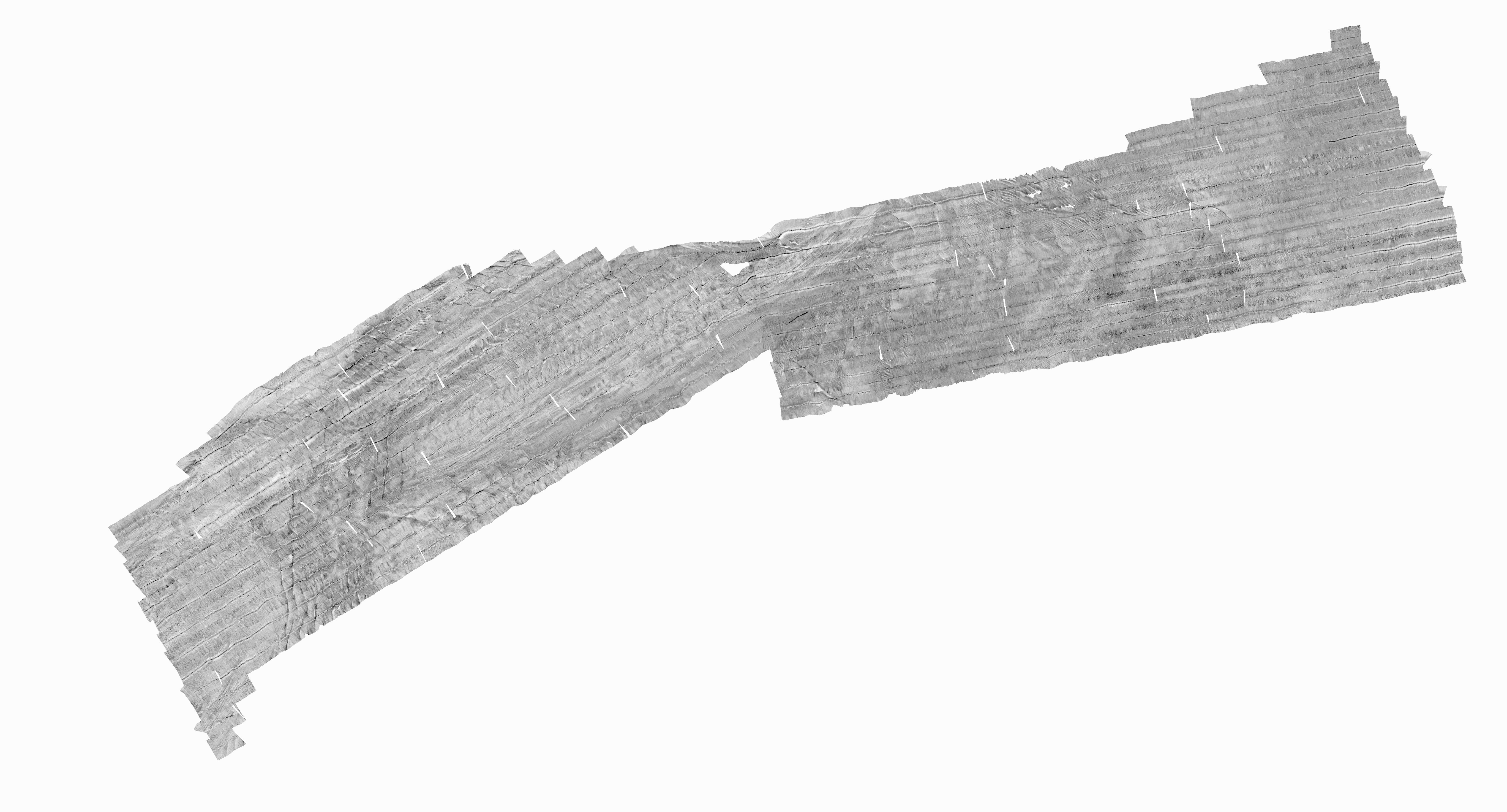
H11078: NOS Hydrographic Survey , Pollock Rip Channel, Massachusetts, 2001-09-13
The National Oceanic and Atmospheric Administration (NOAA) has the statutory mandate to collect hydrographic data in support of nautical chart compilation for safe navigation... -
Chemical and physical oceanographic profile data collected from CTD casts aboard the Meg L. Skansi in the Gulf of Mexico from 2010-09-04 to 2010-09-13 in response to the Deepwater Horizon oil spill event (NCEI Accession 0069076)
Chemical and physical oceanographic profile data were collected aboard the Meg L. Skansi in the Gulf of Mexico from 2010-09-04 to 2010-09-13 in response to the Deepwater Horizon... -
SanctSound Sound Propagation Models
The map shows the signal-to-noise ratio (SNR) calculated as the difference between predicted received level (RL) at the hydrophone and the wind-induced noise level (WN). The RL... -
Seawater Temperature and Salinity Moored Time-Series Records, Collected During 2010 and 2011 in Vieques Sound and Virgin Passage (NODC Accession 0088063)
Sea-Bird SBE37SM MicroCat Conductivity/Temperature (CT) recorders were deployed between March 2010 and April 2011 on shallow water moorings located in Vieques Sound, Puerto... -
Physical and meteorological delayed-mode full-resolution data from the Tropical Atmosphere Ocean (TAO) array in the Equatorial Pacific
The Tropical Atmosphere Ocean (TAO) array of moored buoys spans the tropical Pacific. Moorings within the array measure surface meteorological and upper-ocean parameters. This... -
Ground-Based Global Positioning System (GPS) Meteorology Integrated Precipitable Water Vapor (IPW)
The Ground-Based Global Positioning System (GPS) Meteorology Integrated Precipitable Water Vapor (IPW) data set measures atmospheric water vapor using ground-based GPS... -
2013 Tanker Vessel Density
Automatic Identification Systems (AIS) are a navigation safety device that transmits and monitors the location and characteristics of many vessels in U.S. and international... -
Puget Sound 1/3 arc-second NAVD 88 Coastal Digital Elevation Model
NOAA's National Geophysical Data Center (NGDC) is building high-resolution digital elevation models (DEMs) for select U.S. coastal regions. These integrated bathymetric-... -
GHRSST Level 3P Global Subskin Sea Surface Temperature from the Advanced Very High Resolution Radiometer (AVHRR) on the MetOp-A satellite (GDS version 1)
A global Level 3 Group for High Resolution Sea Surface Temperature (GHRSST) dataset from the Advanced Very High Resolution Radiometer (AVHRR) on the MetOp-A platform (launched... -
Mountains in the Sea - Exploring the New England Seamount Chain on RV Atlantis in North Atlantic Ocean between 20030711 and 20030719
This summer, an interdisciplinary scientific team spent 9 days aboard the Woods Hole Oceanographic Institution's research vessel Atlantis II and used the deep-sea manned... -
Sea Scallop Survey
The standardized NEFSC Sea Scallop Survey began in 1980 and has covered an area from Cape Hatteras to Georges Bank. The survey aims to determine the distribution and abundance... -
Oceanographic data and ROV dive-related multimedia and information collected during the EX1606 (CAPSTONE Wake Island Unit PRIMNM (ROV & Mapping)) expedition on NOAA Ship OKEANOS EXPLORER in the North Pacific Ocean from 2016-07-27 to 2016-08-19 (NCEI Accession 0156560)
This dataset contains oceanographic data collected in the deep water areas around Wake Island and along transits from Guam to Kwajalein. Operations will use the shipâs deep... -
Ionospheric Oblique Incidence Soundings by Satellites
The oblique incidence sweep-frequency ionospheric sounding technique uses the same principle of operation as the vertical incidence sounder. The primary difference is that the... -
2026 NOAA NGS Ortho-rectified 4 band Mosaic: Jacksonville, FL
This data set contains 4-band ortho-rectified mosaic tiles, created as a product from the NOAA Integrated Ocean and Coastal Mapping (IOCM) initiative. The source imagery was... -
Net primary productivity (NPP) and associated parameters for the U.S. outer continental shelf waters, 1998-2009 (NCEI Accession 0071184)
This dataset consists of monthly net primary productivity (NPP) estimates for 1998-2009 derived from the Vertically Generalized Production Model (VGPM) for the 26 Outer... -
MYAKKA RIVER AT MYAKKA CITY FL (USGS 02298608)
Timeseries data from 'MYAKKA RIVER AT MYAKKA CITY FL (USGS 02298608)' (gov_usgs_nwis_02298608) -
H12551: NOS Hydrographic Survey , Approaches to Barataria Bay, LA, 2014-01-20
The National Oceanic and Atmospheric Administration (NOAA) has the statutory mandate to collect hydrographic data in support of nautical chart compilation for safe navigation...

Official websites use .gov
A
.gov website belongs to an official government
organization in the United States.
Secure .gov websites use HTTPS
A
lock (
) or https:// means you’ve safely connected to
the .gov website. Share sensitive information only on official,
secure websites.