
-
Effects of ocean acidification on the embryos and larvae of red king crab, Paralithodes camtschaticus (NCEI Accession 0170752)
This dataset contains a laboratory experiment study with the goal of understanding the effects of ocean acidification on the embryos and larvae of red king crab, Paralithodes... -
H05571: NOS Hydrographic Survey , 1934-12-31
The National Oceanic and Atmospheric Administration (NOAA) has the statutory mandate to collect hydrographic data in support of nautical chart compilation for safe navigation... -
B00093: NOS Hydrographic Survey , 1986-11-22
The National Oceanic and Atmospheric Administration (NOAA) has the statutory mandate to collect hydrographic data in support of nautical chart compilation for safe navigation... -
L01824: NOS Hydrographic Survey , 1943-12-31
The National Oceanic and Atmospheric Administration (NOAA) has the statutory mandate to collect hydrographic data in support of nautical chart compilation for safe navigation... -
B00115: NOS Hydrographic Survey , 1987-10-09
The National Oceanic and Atmospheric Administration (NOAA) has the statutory mandate to collect hydrographic data in support of nautical chart compilation for safe navigation... -
B00079: NOS Hydrographic Survey , 1986-10-22
The National Oceanic and Atmospheric Administration (NOAA) has the statutory mandate to collect hydrographic data in support of nautical chart compilation for safe navigation... -
Multibeam collection for RB1201: Multibeam data collected aboard NOAA Ship RONALD H. BROWN (R104) from 18-Feb-12 to 03-Mar-12, Charleston, South Carolina to Charleston, South Carolina
This data set is part of a larger set of data called the Multibeam Bathymetry Database (MBBDB) where other similar data can be found -
OSU SST Climatology V2, MODIS Aqua, West US, 2002-2003, Lon0360
This suite of CHLA and SST climatology and anomaly data products are derived from daily, 0.0125 degree x 0.0125 degree, MODIS Aqua CHLA and SST fields that cover the California... -
Wind, Metop-A ASCAT, 0.25°, Global, Near Real Time, 2009-present (14 Day), Lon+/-180
NOAA CoastWatch distributes near real time wind data originating with wind velocity measurements from the ASCAT instrument onboard EUMETSAT's Metop-A satellite. ASCAT is a... -
NOAA/WDS Paleoclimatology - Kanfoush et al. 2002 South Atlantic ODP1094 444KYr Ice Rafted Debris Data
This archived Paleoclimatology Study is available from the NOAA National Centers for Environmental Information (NCEI), under the World Data Service (WDS) for Paleoclimatology.... -
NOAA/WDS Paleoclimatology - Nauru Island - Stable Isotope Data
This archived Paleoclimatology Study is available from the NOAA National Centers for Environmental Information (NCEI), under the World Data Service (WDS) for Paleoclimatology.... -
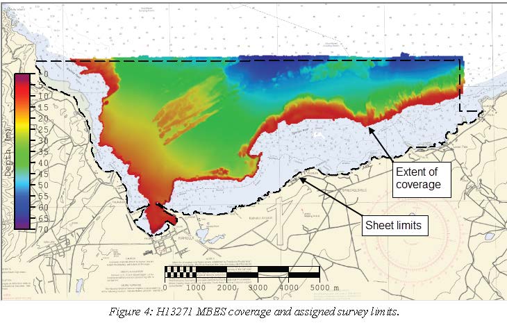
H13271: NOS Hydrographic Survey , 2019-08-08
The National Oceanic and Atmospheric Administration (NOAA) has the statutory mandate to collect hydrographic data in support of nautical chart compilation for safe navigation... -
H11322: NOS Hydrographic Survey , Buzzard Bay and Rhode Island Sound, Rhode Island, 2004-07-16
The National Oceanic and Atmospheric Administration (NOAA) has the statutory mandate to collect hydrographic data in support of nautical chart compilation for safe navigation... -
The NOAA and MMS Marine Minerals Bibliography
From 1983 through 1992, the National Oceanic and Atmospheric Administration (NOAA) National Geophysical Data Center (NGDC) compiled a comprehensive, computerized bibliography of... -
Multibeam collection for HB1906L4: Multibeam data collected aboard NOAA Ship HENRY B. BIGELOW (R225) from 30-Oct-19 to 14-Nov-19, Newport, Rhode Island to Newport, RI
This data set is part of a larger set of data called the Multibeam Bathymetry Database (MBBDB) where other similar data can be found -
CRED REA Fish Team Stationary Point Count Surveys at Alamagan Island, 2003
Stationary Point Counts at 4 stations at each survey site were surveyed as part of Rapid Ecological Assessments conducted at 3 sites at Alamagan Island in the Commonwealth of... -
NOAA/WDS Paleoclimatology - Ursilor Cave Geochemical Data from 7100 to -50 Cal Yr BP
This archived Paleoclimatology Study is available from the NOAA National Centers for Environmental Information (NCEI), under the World Data Service (WDS) for Paleoclimatology.... -
H01511A: NOS Hydrographic Survey
The National Oceanic and Atmospheric Administration (NOAA) has the statutory mandate to collect hydrographic data in support of nautical chart compilation for safe navigation... -
Multibeam collection for NF2201: Multibeam data collected aboard NOAA Ship NANCY FOSTER (R352) from 14-Mar-22 to 02-Apr-22, San Juan, Puerto Rico to San Juan, Puerto Rico
This data set is part of a larger set of data called the Multibeam Bathymetry Database (MBBDB) where other similar data can be found

Official websites use .gov
A
.gov website belongs to an official government
organization in the United States.
Secure .gov websites use HTTPS
A
lock (
) or https:// means you’ve safely connected to
the .gov website. Share sensitive information only on official,
secure websites.
.jpg)