
-
Bathythermograph (MBT) data from REYNOLDS in the Bismarck Sea, North Pacific Ocean, and others from 1944-06-14 to 1945-01-24 (NCEI Accession 7600487)
This dataset includes bathythermograph (MBT) data from REYNOLDS in the Bismarck Sea, North Pacific Ocean, Philippine Sea, and South Pacific Ocean from 1944-06-14 to 1945-01-24.... -
Bathythermograph (XBT) data from COLUMBUS CANADA, NOAA Ship Chapman, and others in the Bering Sea, Coastal Waters of Southeast Alaska and British Columbia, and others from 1987-02-25 to 1987-08-28 (NCEI Accession 8700353)
This dataset includes bathythermograph (XBT) data from COLUMBUS CANADA, NOAA Ship Chapman, NOAA Ship John N. Cobb, NOAA Ship McArthur, NOAA Ship Oceanographer, and R/V ROBERT D.... -
Trajectory profile data from glider ru30, including including pH, total alkalinity, water temperature, salinity and aragonite saturation state, deployed by Rutgers, the State University of New Jersey in the Mid-Atlantic Bight from 2021-10-20 to 2021-11-17 (NCEI Accession 0281780)
This dataset contains the trajectory profile data from glider ru30 from one seasonal deployment from 2021-10-20 to 2021-11-17 to investigate carbonate chemistry and monitor... -
pH, alkalinity, temperature, salinity and other variables collected from discrete sample and profile observations using CTD, bottle and other instruments from the THALASSA in the North Atlantic Ocean from 2001-08-23 to 2001-09-13 (NCEI Accession 0113600)
This dataset includes chemical, discrete sample, physical and profile data collected from THALASSA in the North Atlantic Ocean from 2001-08-23 to 2001-09-13 and retrieved during... -
Indian Ocean Near Real-Time Temperature Profile Data from the GTSPP project from 31 December 1989 to 31 July 1990 (NCEI Accession 0000748)
Physical data were collected from XBT casts from the Indian Ocean. Data were collected from 31 December 1989 to 31 July 1990. Data were submitted by the Commonwealth Scientific... -
2016 NOAA NGS Ortho-rectified Near-Infrared Mosaic of Muskegon, Grand Haven,and Holland, Michigan
This data set contains ortho-rectified mosaic tiles, created as a product from the NOAA Integrated Ocean and Coastal Mapping (IOCM) initiative. The source imagery was acquired... -
Quagga mussel (Dreissena rostriformis bugensis) shell and tissue measurements collected in the Laurentian Great Lakes since 2015
Invasive dreissenid mussels (quagga mussels, Dreissena rostriformis bugensis and zebra mussels, D. polymorpha) were introduced to the Laurentian Great Lakes in the 1980âs and... -
Continuously Updated Digital Elevation Model (CUDEM) - 1/3 Arc-Second Resolution Bathymetric-Topographic Tiles NGDA
NOAA's National Centers for Environmental Information (NCEI) is developing a suite of digital elevation models (DEMs) for the U.S. coast to support a variety of NOAA missions,... -
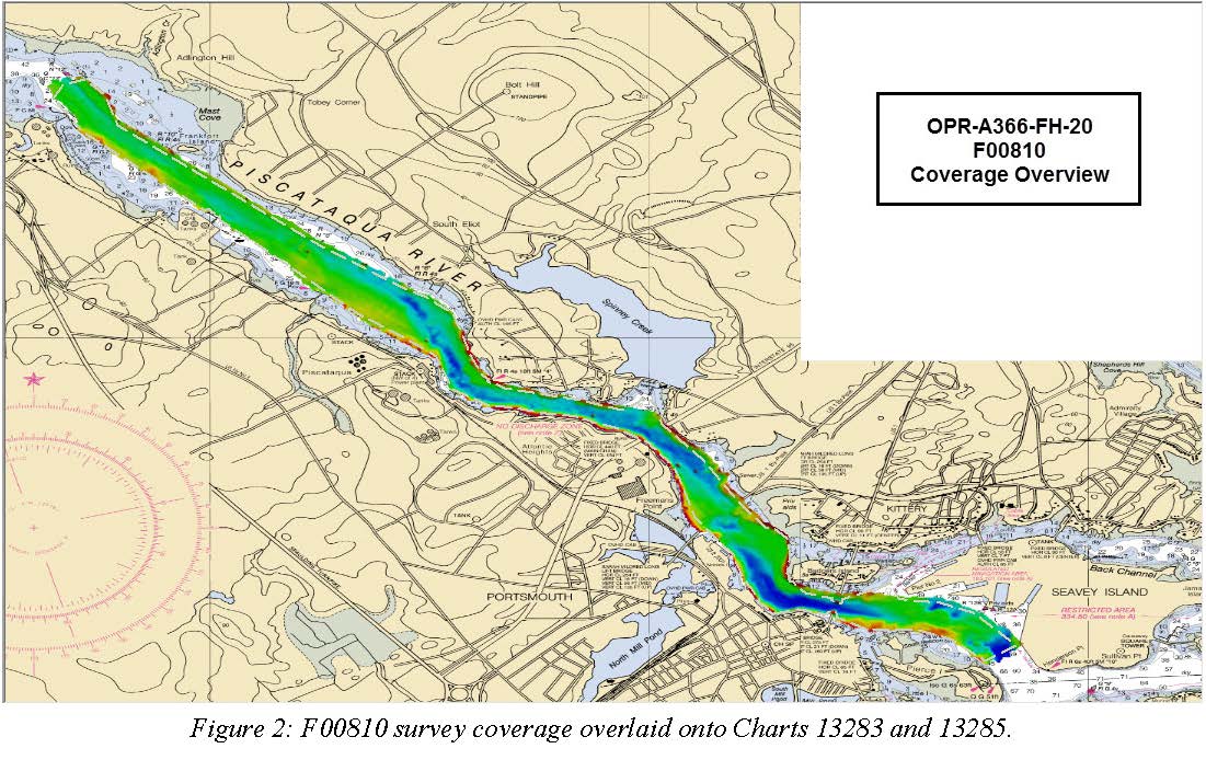
F00810: NOS Hydrographic Survey , 2020-08-05
The National Oceanic and Atmospheric Administration (NOAA) has the statutory mandate to collect hydrographic data in support of nautical chart compilation for safe navigation... -
NOAA Integrated Ocean and Coastal Mapping (IOCM) infrared (IR) orthorectified mosaic image tiles, Lake Charles, Louisiana 2009-2010 (NCEI Accession 0100232)
This data set contains infrared (IR) ortho-rectified mosaic tiles, created as a product from the NOAA Integrated Ocean and Coastal Mapping (IOCM) initiative. The source imagery... -
NOAA Integrated Ocean and Coastal Mapping (IOCM) true color (RGB) and infrared (IR) orthorectified mosaic image tiles, Port of Georgetown - CSCAP (Coast and Shoreline Change Analysis Program), South Carolina, 2010 (NCEI Accession 0074377)
This data set contains ortho-rectified mosaic tiles, created as a product from the NOAA Integrated Ocean and Coastal Mapping (IOCM) initiative of the Port of Georgetown - CSCAP... -
Benthic organisms collected using net casts and other instruments from the R/V VENTURE in the Gulf of Mexico from 1980-10-27 and 1984-04-29 (NCEI Accession 8600027)
Benthic organisms were collected using net, sediment sampler casts, and other instruments from the R/V VENTURE in the Gulf of Mexico from 27 October 1980 to 29 April 1984. Data... -
Current speed and other data collected using current meter casts from the GYRE in part of the International Decade of Ocean Exploration / North Pacific Experiment (IDOE/NORPAX) project from 1979-02-07 to 1980-06-11 (NCEI Accession 8100669)
Current speed, temperature, depth, east-west current component, north-south current component, pressure and other data were collected using current meter casts from the GYRE... -
International Comprehensive Ocean-Atmosphere Data Set (ICOADS)
Surface marine observational records from ships, buoys, and other platform types are processed and binned creating monthly global and regional grids of the observations along... -
Species Distribution: Bottlenose Dolphin - Hawaii
This dataset contains a collection of known point locations of bottlenose dolphins identified either via automated satellite tracking of tagged organisms or through direct human... -
Dissolved inorganic carbon (DIC), total alkalinity, pH on total scale, chlorofluorocarbon-11, chlorofluorocarbon-12, temperature, salinity, oxygen, nutrients and other measurements collected from discrete samples and profile observations during the R/V Ryofu Maru III cruise rf201405 (EXPOCODE 49UP20140609), in the North Pacific Ocean from 2014-06-09 to 2014-06-29 (NCEI Accession 0209174)
This dataset includes discrete profile measurements of dissolved inorganic carbon (DIC), total alkalinity, pH on total scale, chlorofluorocarbon-11, chlorofluorocarbon-12,... -
Coastal Mapping Program of Port of Everett, WA, WA2503-CS-N NGDA
These data provide an accurate high-resolution shoreline compiled from imagery of Port of Everett, WA . This vector shoreline data is based on an office interpretation of... -
2025 SCDVA Lidar: Charleston County, SC
BERKELEY, CHARLESTON, ORANGEBURG LIDAR DATA COLLECTION Lidar Data Acquisition and Processing Production Task - Charleston County Contract Number: 6004 RFQ Number: 6004-25C...

Official websites use .gov
A
.gov website belongs to an official government
organization in the United States.
Secure .gov websites use HTTPS
A
lock (
) or https:// means you’ve safely connected to
the .gov website. Share sensitive information only on official,
secure websites.