
-
Xcel Energy Comanche Station: Pueblo, Colorado (Data)
A partnership with industry and U.S. Department of Energy's National Renewable Energy Laboratory (NREL) to collect solar data to support future solar power generation in the... -
Snake River Plain Play Fairway Analysis: Mountain Home Geothermal Area Natural State Model
The Mountain Home area is characterized by high heat flow and temperature gradient. Temperature data are available from 18 boreholes with depths equal to or greater than 200 m,... -
Rare Earth Element Sorption Study on sieved -50 +100 mesh fraction of Media 1 in Brine 1 with Different Starting pHs at 70C
This is a continuation of the rare earth element sorption study for shaker bath tests on 2g media #1 in 150mL brine #1 with different starting pH's at 70C. In a previous... -
Electrification Futures Study Technology Report Figure Data
The file includes the data for figures in the Electrification Futures Study end-use electric technologies report. Additional information on the data can be found in the report. -
Sodar - Vaisala Triton Wind Profiler, AON8 - Raw Data
Overview This dataset contains measurements from eight different Vaisala Triton Wind Profiler instruments. The Triton Wind Profiler is a sodar wind profiler... -
Surface Meteorological Station - PNNL Short Tower, Umatilla - Raw Data
Overview In support of the Wind Forecasting Improvement Project, Pacific Northwest National Laboratory (PNNL) deployed surface meteorological stations in... -
Utah FORGE: Well 58-32 Schlumberger FMI Logs DLIS and XML files
This zipped data set includes Schlumberger FMI logs DLIS and XML files from Utah FORGE deep well 58-32. These include runs 1 (2226-7550 ft) and 2 (7440-7550 ft). Run 3... -
Brady's Geothermal Field Distributed Temperature Sensing Data
This submission is an 8 day time history of vertical temperature measurements in Brady observation well 56-1 collected during the PoroTomo field experiment. The data was... -
Lidar - HilFlowS - LLNL ZephIR300 - WOP - Processed Data
Overview The ZephIR300 is a continuous wave LIDAR with a range of 10 m to 300 m. During HilFlowS the ZephIR300 was programmed to measure from 10 m to 150 m. In... -
Northwestern Michigan College Formation Thermal Conductivity Test Report
This report summarizes a formation thermal conductivity test performed July 29-31, 2025 on a579-ft vertical bore at Northwestern Michigan College in Traverse City, Michigan. It... -
Lidar - California - Leosphere Windcube 866 (120), Humboldt - Processed Data
Overview The purpose of this dataset is to provide preliminary filtered, averaged lidar data and standardize the data format of various datastreams from the... -
GeoRePORT 2.0 - Protocols and Reporting Tools
Version 2 of the GeoRePORT protocols and excel-based reporting tools. Software allows users to grade the geologic, technical, and socio-economic conditions at a geothermal... -
Ground Magnetic Data for West-Central Colorado
Modeled ground magnetic data was extracted from the Pan American Center for Earth and Environmental Studies database at... -
Electricity Data: Average Retail Price of Electricity Application Programming Interface (API)
This API provides data on average retail price of electricity by major end-use sectors, i.e., residential, commercial, industrial, and transportation. Based on Form EIA-826 and... -
Puerto Rico and Virgin Islands High Resolution Wind Resource
A shapefile of annual average wind resource potential for Puerto Rico and the Virgin Islands at a 50 meter height. This data set has been validated by NREL and wind energy... -
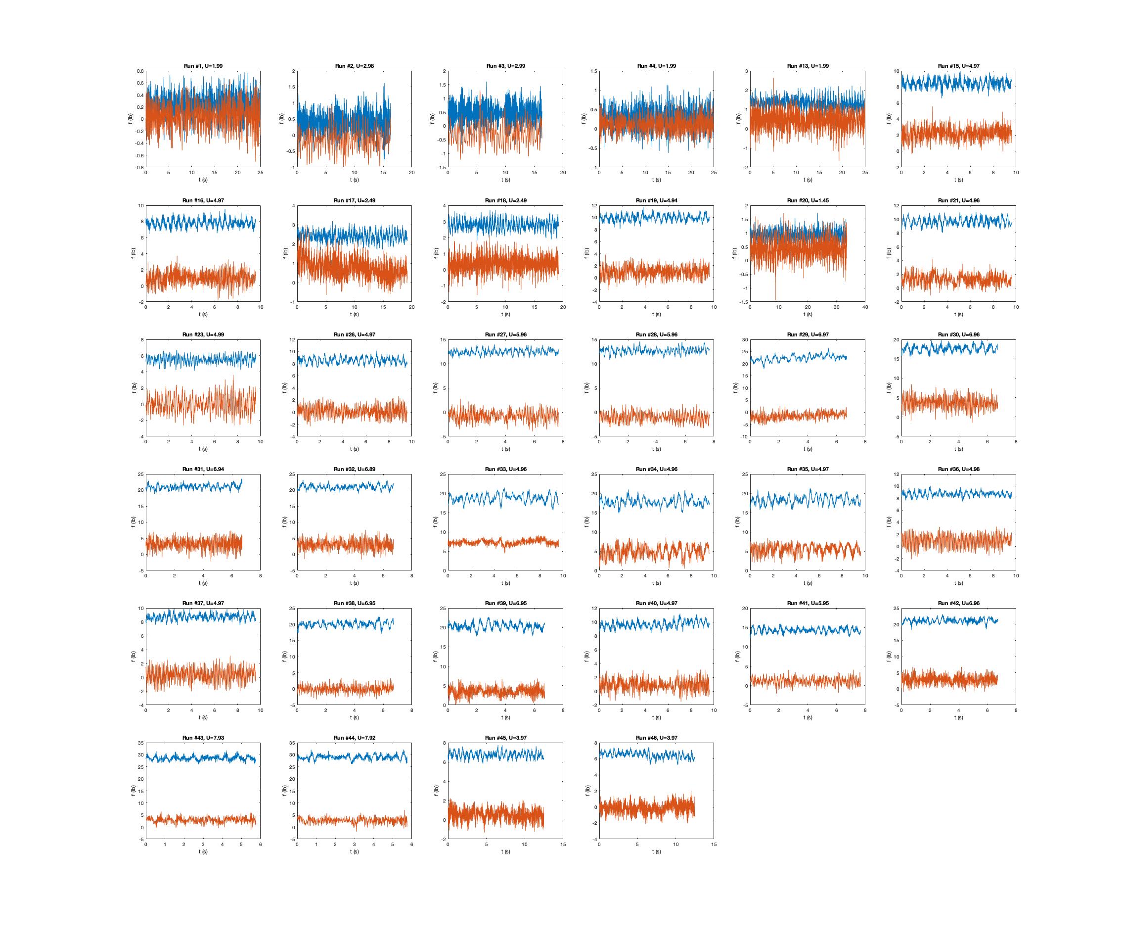
TEAMER: Electrically Engaged Undulation System for Unmanned Underwater Vehicles
This TEAMER RFTS 1 (Request for Technical Support) project supported the flume tank testing of a long range, high endurance unmanned underwater vehicle (UUV) to monitor maritime...

Official websites use .gov
A
.gov website belongs to an official government
organization in the United States.
Secure .gov websites use HTTPS
A
lock (
) or https:// means you’ve safely connected to
the .gov website. Share sensitive information only on official,
secure websites.