-
Federal
Benthic, urchin, and fish observation data collected utilizing multiple methodologies for coral reef carbonate budget assessments in 2021 in O'ahu, in the Mariana Archipelago in 2022, and in American Samoa in 2023
National Oceanic and Atmospheric Administration, Department of Commerce —
This data package includes the benthic, urchin, and fish observation data collected for coral reef carbonate budget assessments by the Ecosystem Sciences Division... -
Federal
Benthic photoquadrat imagery and benthic cover data collected in Nu'uuli Pala Lagoon and Backreef in American Samoa from 2024-11-11 to 2024-11-21
National Oceanic and Atmospheric Administration, Department of Commerce —
This metadata record describes the benthic imagery, raw benthic cover, mean benthic cover, and mean macroalgae cover data of Nu'uuli Pala Lagoon and Backreef in... -
Federal
CRED Simrad em3002d multibeam backscatter data from the banktop and bank edge environments at Tutuila, American Samoa, South Pacific with 1 meter resolution in GeoTIFF format
National Oceanic and Atmospheric Administration, Department of Commerce —
Multibeam backscatter imagery extracted from gridded bathymetry of Tutuila, American Samoa, South Pacific These data provide coverage between 20 and 5000 meters. The... -
Federal
Benthic Surveys in Faga'alu, American Samoa: benthic images collected during belt transect surveys in 2020 (NCEI Accession 0259389)
National Oceanic and Atmospheric Administration, Department of Commerce —
The benthic images provided here are part of the CRCP-funded project aimed at establishing baseline Rapid Ecological Assessment (REA) surveys for coral reef benthic... -
Federal
Structure from Motion (SfM) Coral Vital Rates Annotations derived from Fixed Site Imagery across the U.S. Pacific since 2014
National Oceanic and Atmospheric Administration, Department of Commerce —
The data described here are coral planar area measurements derived from the analysis of benthic photomosaic imagery collected at fixed sites across Pacific Island... -
Federal
Benthic Surveys in Vatia, American Samoa: comprehensive assessment of coral demography (adult and juvenile corals) from belt transect surveys from 2020-01-23 to 2020-01-29 (NCEI Accession 0240417)
National Oceanic and Atmospheric Administration, Department of Commerce —
Jurisdictional managers have expressed concerns that nutrients from the village of Vatia, Tutuila, American Samoa, are having an adverse effect on the adjacent coral... -
Federal
Nutrient and water chemistry data of Nuâuuli Pala Lagoon and Backreef in American Samoa from samples collected along a water quality gradient between 2024-11-08 to 2024-11-20 (NCEI Accession 0307818)
National Oceanic and Atmospheric Administration, Department of Commerce —
The data described here are from water samples collected during NOAA Pacific Islands Fisheries Science Center (PIFSC), Ecosystem Sciences Division (ESD) led fly-in... -
Federal
NCCOS Assessment: Water Quality in Fagatele Bay, National Marine Sanctuary of American Samoa, from 2019-04-22 to 2019-04-26 (NCEI Accession 0247462)
National Oceanic and Atmospheric Administration, Department of Commerce —
This dataset represents water quality chemistry information for Fagatele Bay, a unit of the National Marine Sanctuary of American Samoa (NMSAS). Contaminant groups... -
Federal
CRED Subsurface Temperature Recorder (STR); AMSM, TUT; Long: -170.76311, Lat: -14.36349 (WGS84); Sensor Depth: 13.11m; Data Range: 20050806-20060225.
National Oceanic and Atmospheric Administration, Department of Commerce —
Data from Coral Reef Ecosystem Division (CRED), NOAA Pacific Islands Fisheries Science Center (PIFSC) Subsurface Temperature Recorders (STR) provide a time series of... -
Federal
Identifying coral reef resilience potential in Tutuila, American Samoa based on NOAA coral reef monitoring data from 2010 to 2016 (NCEI Accession 0169632)
National Oceanic and Atmospheric Administration, Department of Commerce —
Declines in the health of coral reef ecosystems lead scientists to search for factors that support reef resilience: the ability of reefs to resist environmental... -
Federal
NCCOS Assessment: Chemical contaminants data from the Fagaâalu Bay and Watershed, American Samoa before and after best management practices from 2014-01-18 to 2022-04-06 (NCEI Accession 0302885)
National Oceanic and Atmospheric Administration, Department of Commerce —
This dataset represents a âbefore and afterâ sediment sampling effort from Fagaâalu Bay and watershed, American Samoa, to evaluate the effectiveness of best... -
Federal
Benthic Surveys in Fagaʻalu, American Samoa: comprehensive assessment of coral demography (adult and juvenile corals) from belt transect surveys from 2020-01-15 to 2020-01-24 (NCEI Accession 0240418)
National Oceanic and Atmospheric Administration, Department of Commerce —
The data described here result from benthic coral demographic surveys within belt transects of specified length and width for two life stages (juveniles and adults)... -
Federal
Benthic Surveys in Faga'alu, American Samoa since 2012: benthic images collected during belt transect surveys in 2012, 2015, 2020
National Oceanic and Atmospheric Administration, Department of Commerce —
The data described herein are part of a NOAA Coral Reef Conservation Program (CRCP) funded project aimed establishing a baseline and assessing the status and trends... -
Federal
CRED REA Benthic Parameter Assessment at Tutuila Island, American Samoa in 2008
National Oceanic and Atmospheric Administration, Department of Commerce —
Point-count surveys at 50-cm intervals were conducted along 2 consecutively placed, 25m line transect lines, as part of Rapid Ecological Assessments conducted at 23... -
Federal
Coral reef ecosystem marine protected area monitoring in Fagamalo, American Samoa: benthic images collected during belt transect surveys in 2015
National Oceanic and Atmospheric Administration, Department of Commerce —
In 2010 the village of Fagamalo, Tutuila, American Samoa, designated a no-take Marine Protected Area that sees the protection of 2.25 square kilometers of ocean.... -
Federal
Shallow Water Conductivity-Temperature-Depth (CTD) Profiles of Aua Reef along a water quality gradient in American Samoa from 2022-09-13 to 2022-09-23 (NCEI Accession 0278377)
National Oceanic and Atmospheric Administration, Department of Commerce —
The data described here is from near-shore shallow water Conductivity-Temperature-Depth (CTD) casts conducted in Aua Reef, American Samoa, by scientists of the... -
Federal
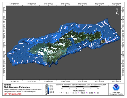
CRED Cumulative Fish Biomass map at Tutuila Island
National Oceanic and Atmospheric Administration, Department of Commerce —
This map displays fish biomass observation locations overlaid on bathymetry. -
Federal
CRED Subsurface Temperature Recorder (STR); AMSM, TUT; Long: -170.76308, Lat: -14.36314 (WGS84); Sensor Depth: 5.18m; Data Range: 20080225-20100220.
National Oceanic and Atmospheric Administration, Department of Commerce —
Data from Coral Reef Ecosystem Division (CRED), NOAA Pacific Islands Fisheries Science Center (PIFSC) Subsurface Temperature Recorders (STR) provide a time series of... -
Federal
Gridded bathymetry of Tutuila Island, American Samoa, South Pacific
National Oceanic and Atmospheric Administration, Department of Commerce —
Gridded (5 m cell size) bathymetry of the shelf and slope environments of Tutuila Island, American Samoa, South Pacific. Almost complete bottom coverage was achieved...

Official websites use .gov
A
.gov website belongs to an official government
organization in the United States.
Secure .gov websites use HTTPS
A
lock (
) or https:// means you’ve safely connected to
the .gov website. Share sensitive information only on official,
secure websites.