
-
Federal
Quality-controlled sea surface marine physical, meteorological and other in situ measurements from the NCEI Surface Underway Marine Database (NCEI-SUMD)
National Oceanic and Atmospheric Administration, Department of Commerce —
This collection contains global in-situ sea surface underway measurements from the NOAA NCEI Surface Underway Marine Database (NCEI-SUMD, formerly the NCEI... -
Federal
EnviroAtlas - Tampa, FL - Ecosystem Services by Block Group
U.S. Environmental Protection Agency —
This EnviroAtlas dataset presents environmental benefits of the urban forest in 1,833 block groups in Tampa Bay, Florida. Carbon attributes, temperature reduction,... -
Federal
Tampa Bay (G070) Bathymetric Digital Elevation Model - NOAA/NOS Estuarine Bathymetry
National Oceanic and Atmospheric Administration, Department of Commerce —
A 1/3 arc-second Mean Lower Low Water bathymetric DEM of NOS hydrographic survey data in Tampa Bay -
Federal
EnviroAtlas - Tampa, FL - Domestic Water Use per Day by U.S. Census Block Group
U.S. Environmental Protection Agency —
As included in this EnviroAtlas dataset, the community level domestic water use was calculated using locally available water use data per capita in gallons of water... -
Federal
D00239: NOS Hydrographic Survey , 2017-09-15
National Oceanic and Atmospheric Administration, Department of Commerce —
The National Oceanic and Atmospheric Administration (NOAA) has the statutory mandate to collect hydrographic data in support of nautical chart compilation for safe... -
Federal
H07749: NOS Hydrographic Survey , 1950-12-31
National Oceanic and Atmospheric Administration, Department of Commerce —
The National Oceanic and Atmospheric Administration (NOAA) has the statutory mandate to collect hydrographic data in support of nautical chart compilation for safe... -
Federal
H07819: NOS Hydrographic Survey , 1950-12-31
National Oceanic and Atmospheric Administration, Department of Commerce —
The National Oceanic and Atmospheric Administration (NOAA) has the statutory mandate to collect hydrographic data in support of nautical chart compilation for safe... -
Federal
EnviroAtlas - Tampa, FL - Land Cover by Block Group
U.S. Environmental Protection Agency —
This EnviroAtlas dataset describes the percentage of each block group that is classified as impervious, forest, green space, wetland, and agriculture. Impervious is a... -
Federal
H12016: NOS Hydrographic Survey , Tampa Bay, Florida, 2010-12-09
National Oceanic and Atmospheric Administration, Department of Commerce —
The National Oceanic and Atmospheric Administration (NOAA) has the statutory mandate to collect hydrographic data in support of nautical chart compilation for safe... -
Federal
Nekton from Fishery-Independent Trawl Samples in U.S. Gulf of Mexico Estuaries: A Comparative Assessment of Gulf Estuarine Systems (CAGES), 1973-2007 (NCEI Accession 0115183)
National Oceanic and Atmospheric Administration, Department of Commerce —
The purpose of CAGES (Comparative Assessment of Gulf Estuarine Systems) is to compile the fishery independent data from five Gulf States into a database to more... -
Federal
H11344: NOS Hydrographic Survey , Tampa Bay, Florida, 2004-06-08
National Oceanic and Atmospheric Administration, Department of Commerce —
The National Oceanic and Atmospheric Administration (NOAA) has the statutory mandate to collect hydrographic data in support of nautical chart compilation for safe... -
Federal
National Status and Trends, Benthic Surveillance Project Pathology, 1984-1992, National Centers for Coastal Ocean Science
National Oceanic and Atmospheric Administration, Department of Commerce —
In order to determine the current status of and to detect any long-term trends in the environmental quality of U.S. nearshore waters, NOAA initiated the National... -
Federal
EnviroAtlas -- Tampa, FL -- Meter-Scale Urban Land Cover (MULC) Data (2010)
U.S. Environmental Protection Agency —
The EnviroAtlas Tampa, FL Meter-Scale Urban Land Cover (MULC) data was generated from USDA NAIP (National Agricultural Imagery Program) four band (red, green, blue... -
Federal
Diet of bonnethead shark in eastern Gulf of Mexico
National Oceanic and Atmospheric Administration, Department of Commerce —
To examine variation in diet and daily ration of the bonnethead, Sphyrna tiburo (Linnaeus, 1758), sharks were collected from three areas in the eastern Gulf of... -
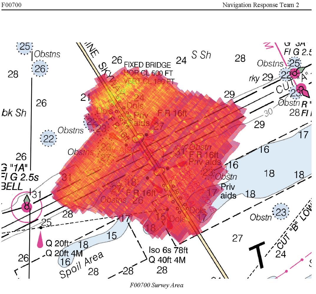
Federal
F00700: NOS Hydrographic Survey , 2018-09-19
National Oceanic and Atmospheric Administration, Department of Commerce —
The National Oceanic and Atmospheric Administration (NOAA) has the statutory mandate to collect hydrographic data in support of nautical chart compilation for safe... -
Federal
EnviroAtlas - Tampa, FL - 51m Riparian Buffer Vegetated Cover
U.S. Environmental Protection Agency —
This EnviroAtlas dataset describes the percentage of a 51-m riparian buffer that is vegetated. There is a potential for decreased water quality in areas where the... -
Federal
F00868: NOS Hydrographic Survey , 2022-09-30
National Oceanic and Atmospheric Administration, Department of Commerce —
The National Oceanic and Atmospheric Administration (NOAA) has the statutory mandate to collect hydrographic data in support of nautical chart compilation for safe... -
Federal
Estuarine Salinity Zones in US East Coast, Gulf of Mexico, and US West Coast from 1999-01-01 to 1999-12-31 (NCEI Accession 0127396)
National Oceanic and Atmospheric Administration, Department of Commerce —
These unprojected (geographic coordinates) 3-Zone Average Annual Salinity Digital Geographies are based on analysis of long-term salinity data for 147 estuaries of... -
Federal
F00909: NOS Hydrographic Survey , 2024-09-30
National Oceanic and Atmospheric Administration, Department of Commerce —
The National Oceanic and Atmospheric Administration (NOAA) has the statutory mandate to collect hydrographic data in support of nautical chart compilation for safe... -
Federal
Tampa Bay , Florida 1/3 arc-second NAVD 88 Coastal Digital Elevation Model
National Oceanic and Atmospheric Administration, Department of Commerce —
NOAA's National Geophysical Data Center (NGDC) is building high-resolution digital elevation models (DEMs) for select U.S. coastal regions. These integrated...

Official websites use .gov
A
.gov website belongs to an official government
organization in the United States.
Secure .gov websites use HTTPS
A
lock (
) or https:// means you’ve safely connected to
the .gov website. Share sensitive information only on official,
secure websites.
.jpg)