
-
Federal
U.S. Climate Risk Projections by County, 2040-2049
National Aeronautics and Space Administration —
The U.S. Climate Risk Projections by County, 2040-2049 data set contains a projection for 2040-2049 risk for the entire contiguous U.S. at the county level with a... -
Federal
Shipping Fairways, Lanes, and Zones for US waters
National Oceanic and Atmospheric Administration, Department of Commerce —
Various shipping zones delineate activities and regulations for marine vessel traffic. Traffic lanes define specific traffic flow, while traffic separation zones... -
Federal
Poverty Mapping Project: Poverty and Food Security Case Studies
National Aeronautics and Space Administration —
The Poverty Mapping Project: Poverty and Food Security Case Studies data set consists of small area estimates of poverty, inequality, food security and related... -
Federal
Critical Facilities for Coastal Geographies
National Oceanic and Atmospheric Administration, Department of Commerce —
The critical facilities data are derived from the USGS Structures Inventory Database (June, 2016). The structures in the derived dataset displays aggregated totals of... -
Federal
Poverty Mapping Project: Global Subnational Prevalence of Child Malnutrition
National Aeronautics and Space Administration —
The Poverty Mapping Project: Global Subnational Prevalence of Child Malnutrition data set consists of estimates of the percentage of children with weight-for-age... -
Federal
India Village-Level Geospatial Socio-Economic Data Set: 1991, 2001
National Aeronautics and Space Administration —
The India Village-Level Geospatial Socio-Economic Data Set: 1991, 2001 is a compilation of the finest level of administrative boundaries in India (village/town-level)... -
Federal
Demographic Trends (1970-2010) for Coastal Geographies
National Oceanic and Atmospheric Administration, Department of Commerce —
The Demographic Trends (1970-2010) were derived from Census Block Group Data for 13 different coastal geographies. For a full listing of the geographies available,... -
Federal
Social Vulnerability Index (SoVI) for New Jersey based on 2000 Census Block Groups
National Oceanic and Atmospheric Administration, Department of Commerce —
This data depicts the social vulnerability of New Jersey census block groups to environmental hazards. Data were culled primarily from the 2000 Decennial Census. -
Federal
China Dimensions Data Collection: China County-Level Data from Provincial Economic Yearbooks, Keyed to 1:1M GIS Map
National Aeronautics and Space Administration —
The China County-Level Data on Provincial Economic Yearbooks, Keyed To 1:1M GIS Map consists of socioeconomic and boundary data for the administrative regions of... -
Federal
Global Earthquake Proportional Economic Loss Risk Deciles
National Aeronautics and Space Administration —
The Global Earthquake Proportional Economic Loss Risk Deciles is a 2.5 minute grid of earthquake hazard economic loss as proportions of Gross Domestic Product (GDP)... -
Federal
NCCOS Sponsored Research Project: Understanding Coral Ecosystem Connectivity in the Gulf of Mexico from Pulley Ridge to the Florida Keys
National Oceanic and Atmospheric Administration, Department of Commerce —
This project investigated the role that the mesophotic coral ecosystems (~60â100 m) of Pulley Ridge (off the southwest coast of Florida) play in replenishing key... -
Federal
Social Vulnerability Index (SoVI) for North Carolina based on 2000 Census Block Groups
National Oceanic and Atmospheric Administration, Department of Commerce —
This data depicts the social vulnerability of North Carolina census block groups to environmental hazards. Data were culled primarily from the 2000 Decennial Census. -
Federal
Coastal Maintained Channels in US waters
National Oceanic and Atmospheric Administration, Department of Commerce —
This layer shows coastal channels and waterways that are maintained and surveyed by the U.S. Army Corps of Engineers (USACE). These channels are necessary... -
Federal
Social Vulnerability Index (SoVI) for Coastal States based on 2000 Census Block Groups
National Oceanic and Atmospheric Administration, Department of Commerce —
This data depicts the social vulnerability of coastal states census block groups to environmental hazards. Data were culled primarily from the 2000 Decennial Census. -
Federal
Global Drought Proportional Economic Loss Risk Deciles
National Aeronautics and Space Administration —
The Global Drought Proportional Economic Loss Risk Deciles is a 2.5 minute grid of drought hazard economic loss as proportions of Gross Domestic Product (GDP) per... -
Federal
Social Vulnerability Index (SoVI) for Texas based on 2000 Census Block Groups
National Oceanic and Atmospheric Administration, Department of Commerce —
This data depicts the social vulnerability of Texas census block groups to environmental hazards. Data were culled primarily from the 2000 Decennial Census. -
Federal
American Community Survey (ACS) 5-Year Estimates for Coastal Geographies
National Oceanic and Atmospheric Administration, Department of Commerce —
The American Community Survey (ACS) is an ongoing statistical survey that samples a small percentage of the population every year. These data have been apportioned to... -
Federal
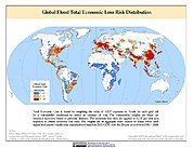
Global Flood Total Economic Loss Risk Deciles
National Aeronautics and Space Administration —
The Global Flood Total Economic Loss Risk Deciles is a 2.5 minute grid of global flood total economic loss risks. A process of spatially allocating Gross Domestic... -
Federal
Global Database of Light-based Geospatial Income Inequality (LGII) Measures, Version 1
National Aeronautics and Space Administration —
The Global Database of Light-based Geospatial Income Inequality (LGII) Measures, Version 1 data set contains Gini-coefficients of inequality for 234 countries and... -
Federal
STEER Coastal Use Mapping Project
National Oceanic and Atmospheric Administration, Department of Commerce —
The Coastal Use Mapping Project is designed to collect critical information on human activities in and near the St. Thomas East End Reserves (STEER). The project...

Official websites use .gov
A
.gov website belongs to an official government
organization in the United States.
Secure .gov websites use HTTPS
A
lock (
) or https:// means you’ve safely connected to
the .gov website. Share sensitive information only on official,
secure websites.