
-
Federal
Landsat 8
National Aeronautics and Space Administration —
The Operational Land Imager (OLI) and Thermal Infrared Sensor (TIRS) are onboard the Landsat 8 satellite, have acquired images of the Earth since February 2013. The... -
Federal
Suomi-NPP VIIRS Geolocation Product Data, version 2
National Aeronautics and Space Administration —
The Visible and Infrared Imager/Radiometer Suite (VIIRS) Geolocation (GEO) Products are data containing terrain corrected solar zenith and azimuth angles, satellite... -
Federal
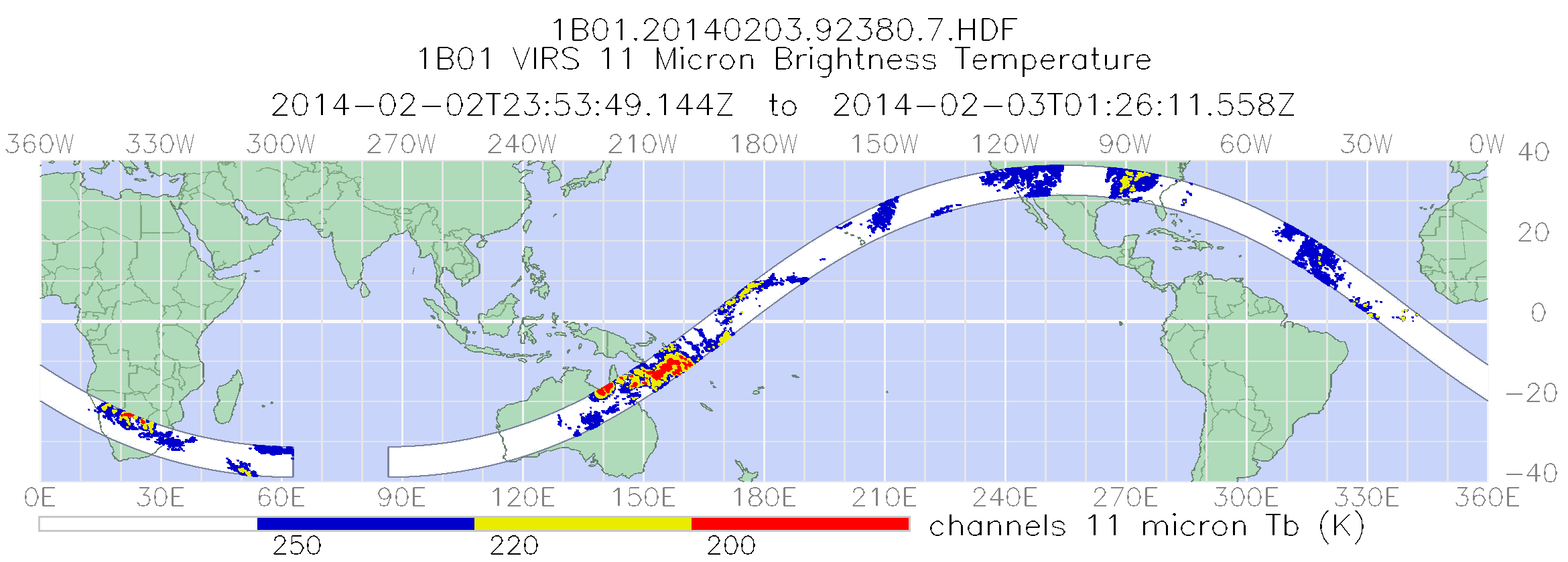
TRMM Visible and Infrared Scanner Calibrated Radiances L1B 1.5 hours V7 (TRMM_1B01) at GES DISC
National Aeronautics and Space Administration —
This TRMM Visible and Infrared Scanner (VIRS) Level 1B Calibrated Radiance Product (1B01) contains calibrated radiances and auxiliary geolocation information from the... -
Federal
ER-2 Navigation Data IMPACTS V1
National Aeronautics and Space Administration —
The NASA ER-2 Navigation Data IMPACTS dataset contains information recorded by the on-board navigation and data collection systems of the NASA ER-2 high-altitude... -
Federal
TRMM Visible and Infrared Scanner Calibrated Radiances L1B 1.5 hours V7 (TRMM_1B01) at GES DISC
National Aeronautics and Space Administration —
This TRMM Visible and Infrared Scanner (VIRS) Level 1B Calibrated Radiance Product (1B01) contains calibrated radiances and auxiliary geolocation information from the... -
Federal
CEOS Cal Val Test Site - Railroad Valley Playa, USA - Instrumented Site NGDA
National Aeronautics and Space Administration —
On the background of these requirements for sensor calibration, intercalibration and product validation, the subgroup on Calibration and Validation of the Committee... -
Federal
OLCI+SLSTR/Sentinel-3A L2 Surface Reflectance and Aerosol parameters over Land
National Aeronautics and Space Administration —
The OLCI+SLSTR/Sentinel-3A L2 Surface Reflectance and Aerosol parameters over Land product with shortname S3A_SY_2_SYN, is generated by combining data acquired by the... -
Federal
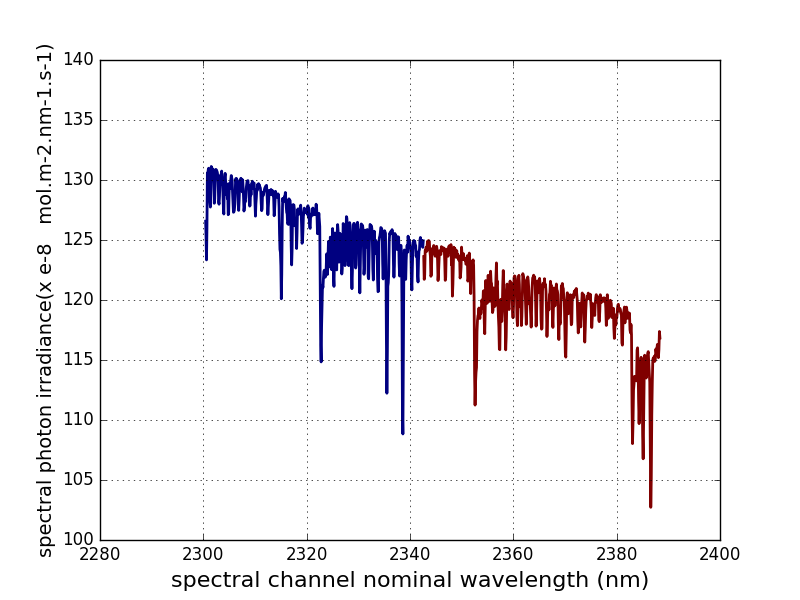
Sentinel-5P TROPOMI Irradiance product SWIR module L1B V2 (S5P_L1B_IR_SIR) at GES DISC
National Aeronautics and Space Administration —
The Copernicus Sentinel-5 Precursor (Sentinel-5P or S5P) satellite mission is one of the European Space Agency's (ESA) new mission family - Sentinels, and it is a... -
Federal
SnowEx20 Grand Mesa Reference GIS Data Sets V001
National Aeronautics and Space Administration —
This data set contains geolocation information of the infrastructure locations for the SnowEx20 Intensive Observation Period (IOP) and Time Series (TS) campaigns.... -
Federal
CEOS Cal Val Test Site - Mauritania 1 - Pseudo-Invariant Calibration Site (PICS) NGDA
National Aeronautics and Space Administration —
On the background of these requirements for sensor calibration, intercalibration and product validation, the subgroup on Calibration and Validation of the Committee... -
Federal
CEOS Cal Val Test Site - Tuz Golu, Turkey - Instrumented Site NGDA
National Aeronautics and Space Administration —
On the background of these requirements for sensor calibration, intercalibration and product validation, the subgroup on Calibration and Validation of the Committee... -
Federal
CEOS Cal Val Test Site - La Crau, France - Instrumented Site NGDA
National Aeronautics and Space Administration —
On the background of these requirements for sensor calibration, intercalibration and product validation, the subgroup on Calibration and Validation of the Committee... -
Federal
CEOS Cal Val Test Site - Frenchman Flat, USA - Instrumented Site NGDA
National Aeronautics and Space Administration —
On the background of these requirements for sensor calibration, intercalibration and product validation, the subgroup on Calibration and Validation of the Committee... -
Federal
TRMM Microwave Imager Calibrated Radiances L1B 1.5 hours V7 (TRMM_1B11) at GES DISC
National Aeronautics and Space Administration —
The new version of these data is in GPM-like format (consistent with the GPM Microwave Imager data format), and can be found under the name GPM_1BTMI (search by... -
Federal
TRMM Attitude and TMI Packets and Header Record L1A V7 (TRMM_1A11) at GES DISC
National Aeronautics and Space Administration —
The Level-1A Product file, "1A11", is a concatenation of Header record, Spacecraft Attitude packets, TMI Housekeeping packets, TMI Science Data packets, QACs and an... -
Federal
SWOT Level 1B Low-Rate Interferogram Data Product, Version 2.0
National Aeronautics and Space Administration —
Interferograms for each of the 9 Doppler beams formed and spatially averaged (low rate) by the On Board Processor, corrected on the ground for phase biases (inherent... -
Federal
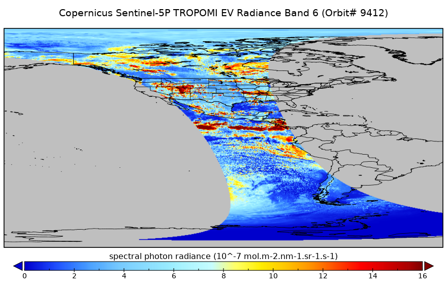
Sentinel-5P TROPOMI Near-Real-Time (NRT) Radiance product band 6 (NIR detector) L1B 5.5km x 3.5km V2 (S5P_L1B_RA_BD6_HiR_NRT) at GES DISC
National Aeronautics and Space Administration —
The Sentinel-5P TROPOMI Near Real Time (NRT) Radiance product band 6 (NIR detector) L1B 5.5km x 21km V2 (S5P_L1B_RA_BD6_HiR_NRT) product at GES DISC is the near real... -
Federal
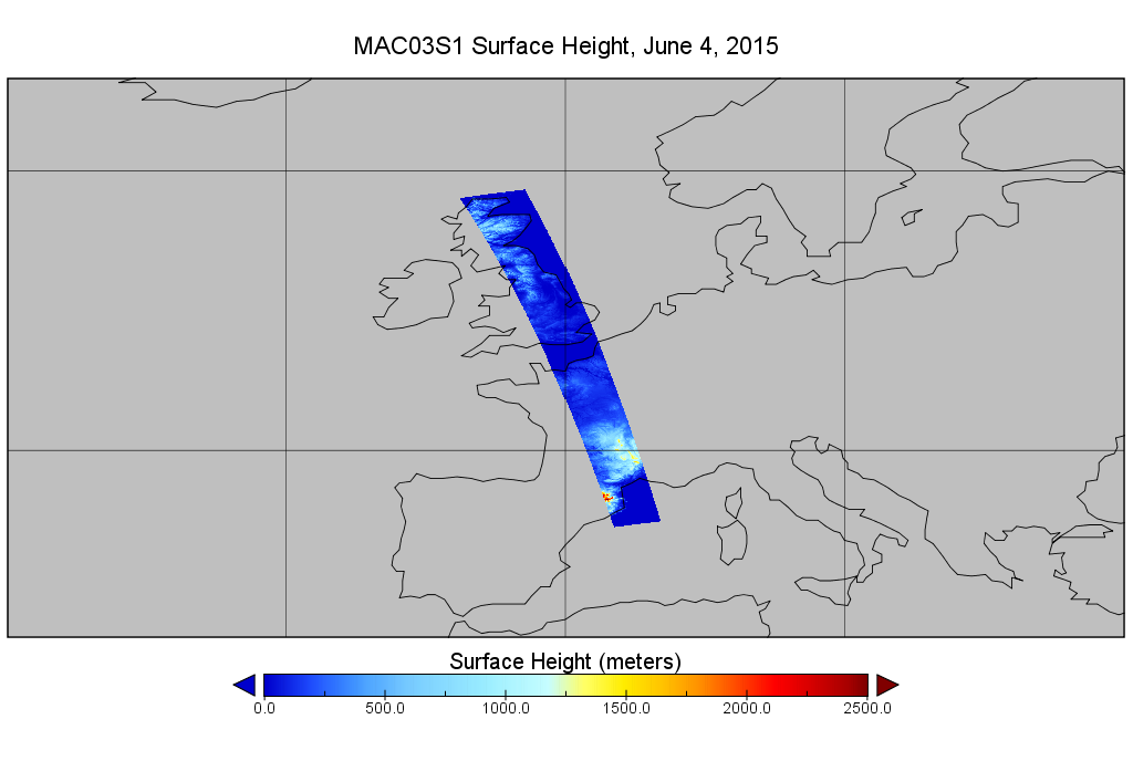
MODIS/Aqua Geolocation Fields 1km 5-Min 1A Wide Swath Subset along CloudSat V002 (MAC03S1) at GES DISC NGDA
National Aeronautics and Space Administration —
This is the wide-swath MODIS/Aqua subset along CloudSat field of view track. The goal of the wide-swath subset is to select and return MODIS data that are within...

Official websites use .gov
A
.gov website belongs to an official government
organization in the United States.
Secure .gov websites use HTTPS
A
lock (
) or https:// means you’ve safely connected to
the .gov website. Share sensitive information only on official,
secure websites.