

132 datasets found
-
Federal
RGB-averaged orthoimagery of coastal North Carolina, from 2020-02-08 to 2020-02-09
Department of the Interior —
RGB-averaged orthoimages were created from aerial imagery collected February 08 and 09, 2020, along the North Carolina coast between the Virginia-North Carolina... -
Federal
40 meter ESRI binary grid of single beam and swath bathymetry of inner continental shelf north of Cape Hatteras, NC to Virginia border (nhatt, UTM Zone 18N, WGS 84)
Department of the Interior —
The northeastern North Carolina coastal system, from False Cape, Virginia, to Cape Lookout, North Carolina, has been studied by a cooperative research program that... -
Federal
JPEG images of chirp seismic data from a 2002 nearshore survey collected by Virginia Institute of Marine Science
Department of the Interior —
The northeastern North Carolina coastal system, from False Cape, Virginia, to Cape Lookout, North Carolina, has been studied by a cooperative research program that... -
Federal
U.S. Geological Survey calculated recurrence interval of sediment mobility at select points in the South Atlantic Bight for May 2010 to May 2011 (SAB_mobile_freq, Geographic, WGS 84)
Department of the Interior —
The U.S. Geological Survey has been characterizing the regional variation in shear stress on the sea floor and sediment mobility through statistical descriptors. The... -
Federal
Digital elevation models (DEMs) of coastal North Carolina, from 2020-02-08 to 2020-02-09
Department of the Interior —
Digital elevation models (DEMs) were created from aerial imagery collected February 08 and 09, 2020, along the North Carolina coast between the Virginia-North... -
Federal
Boomer shotpoint navigation from USGS cruise 2001-013-FA from Albemarle Sound, North Carolina (bbb2001013_shots.shp)
Department of the Interior —
The northeastern North Carolina coastal system, from False Cape, Virginia, to Cape Lookout, North Carolina, has been studied by a cooperative research program that... -
Federal
JPEG images of chirp seismic data from inner shelf U.S. Geological Survey research cruise 2002-013-FA collected by the U.S. Geological Survey
Department of the Interior —
The northeastern North Carolina coastal system, from False Cape, Virginia, to Cape Lookout, North Carolina, has been studied by a cooperative research program that... -
Federal
JPEG images of boomer seismic data from inner shelf U.S. Geological Survey research cruise 2002-012-FA collected by the U.S. Geological Survey
Department of the Interior —
The northeastern North Carolina coastal system, from False Cape, Virginia, to Cape Lookout, North Carolina, has been studied by a cooperative research program that... -
Federal
Structure grid of the depth to the Pleistocene surface (Q30), inner shelf and back-barrier from Virginia border to Cape Lookout, North Carolina (q30depth, ESRI binary grid, 200 m cell size, UTM Zone 18N, WGS 84)
Department of the Interior —
The northeastern North Carolina coastal system, from False Cape, Virginia, to Cape Lookout, North Carolina, has been studied by a cooperative research program that... -
Federal
40 meter ESRI binary grid of swath bathymetry of inner continental shelf south of Cape Hatteras, NC to Cape Lookout, NC (shatt, UTM Zone 18N, WGS84)
Department of the Interior —
The northeastern North Carolina coastal system, from False Cape, Virginia, to Cape Lookout, North Carolina, has been studied by a cooperative research program that... -
Federal
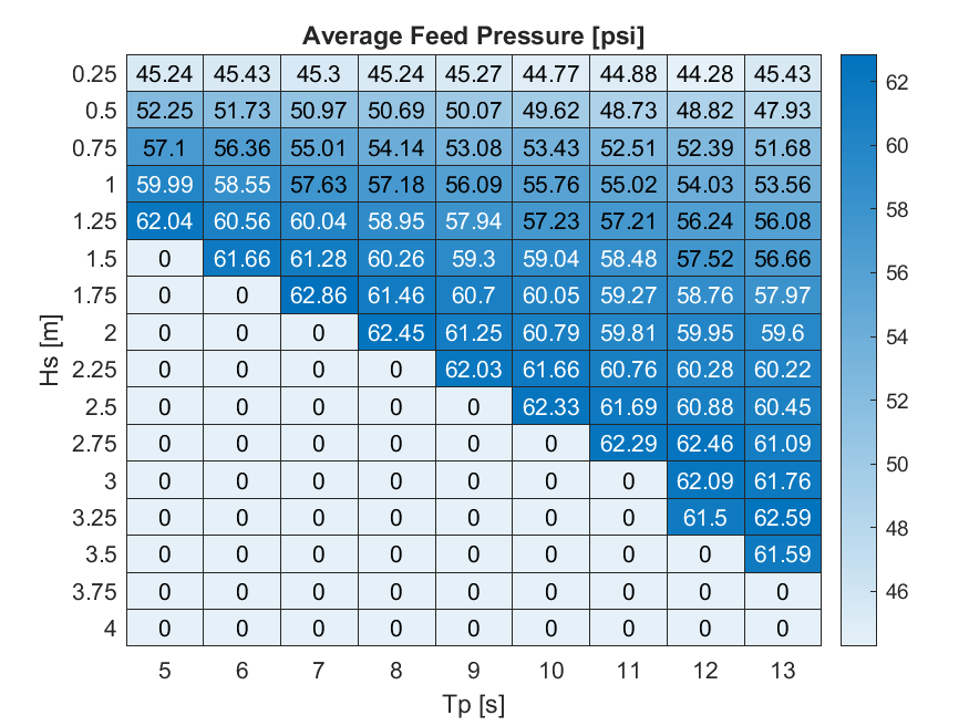
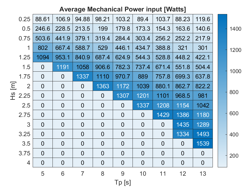
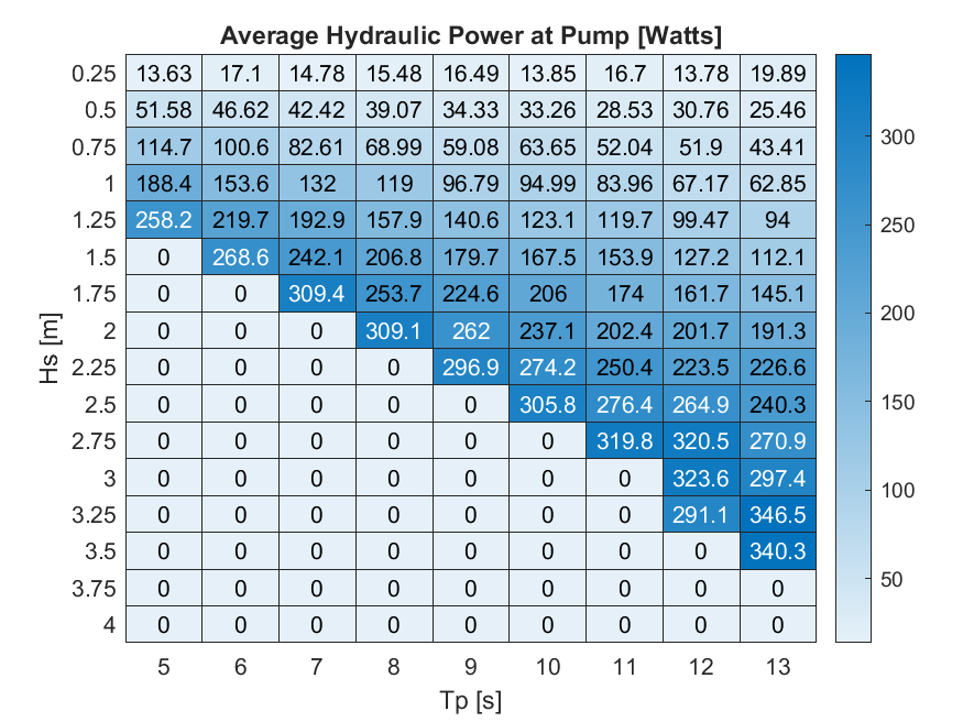
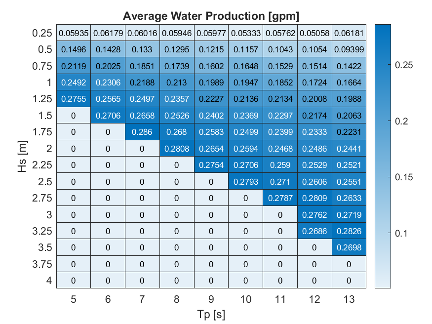
HERO WEC V1.0 - WEC-Sim Detailed Simulation Runs and Summary Data
Department of Energy —
Data sets from simulation runs include 144 wave cases that were run based on the WEC-Sim model (https://mhkdr.openei.org/submissions/483). The 144 wave cases... -
Federal
RGB-averaged orthoimagery of coastal North Carolina, from 2019-09-08 to 2019-09-13, Post-Hurricane Dorian
Department of the Interior —
RGB-averaged ortho products were created from aerial imagery collected between September 8 and 13, 2019, along the North Carolina coast between the Virginia-North... -
Federal
Structure grid of the depth to the top of Pleistocene (Q99), inner shelf and back-barrier from Virginia border to Cape Lookout, North Carolina (q99depth, ESRI binary grid, 400 m cell size, UTM Zone 18N, WGS 84)
Department of the Interior —
The northeastern North Carolina coastal system, from False Cape, Virginia, to Cape Lookout, North Carolina, has been studied by a cooperative research program that... -
Federal
JPEG images of boomer seismic data from inner shelf U.S. Geological Survey research cruise 2002-013-FA collected by the U.S. Geological Survey
Department of the Interior —
The northeastern North Carolina coastal system, from False Cape, Virginia, to Cape Lookout, North Carolina, has been studied by a cooperative research program that... -
Federal
Aerial Imagery of the North Carolina Coast: 2020-08-05 to 2020-08-08, Post-Hurricane Isaias
Department of the Interior —
The U.S. Geological Survey (USGS) Remote Sensing Coastal Change (RSCC) project collects aerial imagery along coastal swaths with optimized endlap/sidelap and precise... -
Federal
Shot navigation for North Carolina barrier island ground penetrating radar collected by East Carolina University in 2002 (ilgpr2002_shots.shp)
Department of the Interior —
The northeastern North Carolina coastal system, from False Cape, Virginia, to Cape Lookout, North Carolina, has been studied by a cooperative research program that... -
Federal
4 meter sidescan-sonar GeoTIFF image of inner shelf with stretched histogram, from Cape Hatteras, NC to Cape Lookout, NC (composite_shatt_str.tif, UTM, Zone 18N, WGS84)
Department of the Interior —
The northeastern North Carolina coastal system, from False Cape, Virginia, to Cape Lookout, North Carolina, has been studied by a cooperative research program that... -
Federal
Structure grid of the depth to the Pliocene surface (Q0), inner shelf and back-barrier from Virginia border to Cape Lookout, North Carolina (q0depth,ESRI binary grid, 200 m cell size, UTM Zone 18N, WGS 84)
Department of the Interior —
The northeastern North Carolina coastal system, from False Cape, Virginia, to Cape Lookout, North Carolina, has been studied by a cooperative research program that... -
Federal
Aerial Imagery of the North Carolina Coast: 2020-08-02, Pre-Hurricane Isaias
Department of the Interior —
The U.S. Geological Survey (USGS) Remote Sensing Coastal Change (RSCC) project collects aerial imagery along coastal swaths with optimized endlap/sidelap and precise... -
Federal
0.8 meter backscatter JPEG image (with world file) of the nearshore seafloor off of Nags Head, NC (mosaic6.jpg, UTM Zone 18N, WGS84)
Department of the Interior —
The northeastern North Carolina coastal system, from False Cape, Virginia, to Cape Lookout, North Carolina, has been studied by a cooperative research program that...
132 datasets found