

93 datasets found
-
Federal
Aqua MODIS Global Mapped Chlorophyll (CHL) - NRT Data, version R2022.0 NGDA
National Aeronautics and Space Administration —
The Ocean Biology DAAC produces near real-time (quicklook) products using the best-available combination of ancillary data from meteorological and ozone data. As... -
Federal
NOAA-20 VIIRS Global Mapped Chlorophyll (CHL) - NRT Data, version R2022.0
National Aeronautics and Space Administration —
The Ocean Biology DAAC produces near real-time (quicklook) products using the best-available combination of ancillary data from meteorological and ozone data. As... -
Federal
CMS: Simulated Physical-Biogeochemical Data, SABGOM Model, Gulf of Mexico, 2005-2010
National Aeronautics and Space Administration —
This dataset contains monthly mean ocean surface physical and biogeochemical data for the Gulf of Mexico simulated by the South Atlantic Bight and Gulf of Mexico... -
Federal
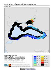
Indicators of Coastal Water Quality: Change in Chlorophyll-a Concentration 1998-2007
National Aeronautics and Space Administration —
The Change in Chlorophyll-a Concentrations 1998-2007 component of the Indicators of Coastal Water Quality Collection represents a tabular time series of the... -
Federal
Sonde data of continuous surface water flow-through system for the West Florida Shelf: USGS Cruise 11CEV02
Department of the Interior —
The United States Geological Survey (USGS) is conducting a study on the effects of climate change on ocean acidification within the Gulf of Mexico; dealing... -
Federal
Surface water data for samples collected approximately hourly along the West Florida Shelf: USGS Cruise 11BHM02
Department of the Interior —
The United States Geological Survey (USGS) is conducting a study on the effects of climate change on ocean acidification within the Gulf of Mexico; dealing... -
Federal
Surface water data for samples collected approximately hourly along the West Florida Shelf: USGS Cruise 11BHM01
Department of the Interior —
The United States Geological Survey (USGS) is conducting a study on the effects of climate change on ocean acidification within the Gulf of Mexico; dealing... -
Federal
Suomi-NPP VIIRS Regional Ocean Color (OC) - Near Real Time (NRT) Data, version R2022.0
National Aeronautics and Space Administration —
The Ocean Biology DAAC produces near real-time (quicklook) products using the best-available combination of ancillary data from meteorological and ozone data. As... -
State
MD iMAP: Maryland Soils - Chesapeake Bay Sand Silt Clay
State of Maryland —
This is a MD iMAP hosted service layer. Find more information at http://imap.maryland.gov. This is a data table - in comma-delimited - ASCII format - which contains... -
Federal
Navigation and environmental data from R/V Weatherbird II for the West Florida Shelf: USGS Cruise 11BHM01
Department of the Interior —
The United States Geological Survey (USGS) is conducting a study on the effects of climate change on ocean acidification within the Gulf of Mexico; dealing... -
Federal
Sonde data of continuous surface water flow-through system for the West Florida Shelf: USGS Cruise 11BHM01
Department of the Interior —
The United States Geological Survey (USGS) is conducting a study on the effects of climate change on ocean acidification within the Gulf of Mexico; dealing... -
Federal
NOAA-21 VIIRS Global Mapped Particulate Organic Carbon (POC) - Near Real Time (NRT) Data, version R2022.0
National Aeronautics and Space Administration —
The Ocean Biology DAAC produces near real-time (quicklook) products using the best-available combination of ancillary data from meteorological and ozone data. As... -
Federal
NOAA-20 VIIRS Global Binned Particulate Organic Carbon (POC) - Near Real Time (NRT) Data, version R2022.0
National Aeronautics and Space Administration —
The Ocean Biology DAAC produces near real-time (quicklook) products using the best-available combination of ancillary data from meteorological and ozone data. As... -
Federal
NOAA-20 VIIRS Global Mapped Particulate Inorganic Carbon (PIC) - Near Real Time (NRT) Data, version R2022.0
National Aeronautics and Space Administration —
The Ocean Biology DAAC produces near real-time (quicklook) products using the best-available combination of ancillary data from meteorological and ozone data. As... -
Federal
Suomi-NPP VIIRS Global Binned Chlorophyll (CHL) - NRT Data, version R2022.0
National Aeronautics and Space Administration —
The Ocean Biology DAAC produces near real-time (quicklook) products using the best-available combination of ancillary data from meteorological and ozone data. As... -
Federal
Terra MODIS Global Mapped Chlorophyll (CHL) - NRT Data, version R2022.0 NGDA
National Aeronautics and Space Administration —
The Ocean Biology DAAC produces near real-time (quicklook) products using the best-available combination of ancillary data from meteorological and ozone data. As... -
Federal
Circumpolar Flaw Lead System Study
National Aeronautics and Space Administration —
Measurements taken within the Cape Bathurst flaw lead on board the icebreaker C.C.G.S. Amundsen to examine how physical changes affect biological processes in the... -
State
MD iMAP: Maryland Soils - Chesapeake Bay Clayey Sand
State of Maryland —
This is a MD iMAP hosted service layer. Find more information at http://imap.maryland.gov. This is a data table - in comma-delimited - ASCII format - which contains... -
Federal
Indicators of Coastal Water Quality: Annual Chlorophyll-a Concentration 1998-2007
National Aeronautics and Space Administration —
The Annual Chlorophyll-a Concentrations component of the Indicators of Coastal Water Quality Collection consists of gridded satellite measurements of chlorophyll-a...
93 datasets found