

87 datasets found
-
Federal
Water Use in Enhanced Geothermal Systems (EGS): Geology of U.S. Stimulation Projects, Water Costs, and Alternative Water Use Policies
Department of Energy —
According to the Energy Information Administration (EIA) of the U.S. Department of Energy (DOE), geothermal energy generation in the United States is projected to... -
Federal
TIGER/Line Shapefile, 2024, County, Newberry County, SC, All Roads
U.S. Census Bureau, Department of Commerce —
The TIGER/Line shapefiles and related database files (.dbf) are an extract of selected geographic and cartographic information from the U.S. Census Bureau's Master... -
Federal
Airborne geophysical survey: Newberry, Oregon
Department of the Interior —
Aeromagnetic data were collected along flight lines by instruments in an aircraft that recorded magnetic-field values and locations. This dataset presents latitude,... -
Federal
Validation of Innovative Exploration Technologies for Newberry Volcano: Raw Seismic Data
Department of Energy —
Validation of Innovative Exploration Technologies for Newberry Volcano: Seismic data - raw taken by Apex Hipoint for 1st test 2012 (data in .ff format) -
Federal
DEEPEN Data Catalog for Magmatic Geothermal Systems in the United States
Department of Energy —
This data catalog contains information related to the Training Site Analysis for the Geothermica project "DE-risking Exploration of geothermal Plays in magmatic... -
Federal
MT Data: Newberry 4D Monitoring EGS Project
Department of Energy —
This submission contains a link to the EDX Collaborative Workspace where the MT data collected in support of the DOE GTO 4D EGS monitoring project is stored. Daily... -
Federal
Plots of Wind Patterns for the World’s Volcanoes
Department of the Interior —
This product includes rose diagrams and tables of wind patterns at volcanoes listed in the Smithsonian Institution’s Volcanoes of the World Database. At each volcano,... -
Federal
Newberry EGS Demonstration: Well 55-29 Stimulation Data 2014
Department of Energy —
The Newberry Volcano EGS Demonstration in central Oregon, a 5 year project begun in 2010, tests recent technological advances designed to reduce the cost of power... -
Federal
Validation of Innovative Exploration Technologies for Newberry Volcano: Lithology Reports of TGWs
Department of Energy —
Validation of Innovative Exploration Technologies for Newberry Volcano: Lithology Reports of Temperature Gradient Wells -
Federal
Newberry EGS Well Logs, Earthquakes, Maps, Cross-Sections, and LiDAR Datasets
Department of Energy —
Datasets and information used to characterize the subsurface of Newberry and support modeling efforts. Includes sources for well logs, earthquakes, maps & cross-... -
Federal
Validation of Innovative Exploration Technologies for Newberry Volcano: Drilling Summary
Department of Energy —
Drilling summary from validation of innovative exploration technologies for Newberry Volcano, including depths, dates, and drilling statistics from 2012 -
Federal
Initial 3D Gravity Results at Newberry
Department of Energy —
Initial 3D gravity results from Zonge Int'l recorded for the 4D EGS Monitoring project at Newberry, during stimulation of Well 55-29 by AltaRock Energy -
Federal
Validation of Innovative Exploration Technologies for Newberry Volcano: Geochemistry Data from Wells 55-29 and 46-16
Department of Energy —
Validation of Innovative Exploration Technologies for Newberry Volcano: DOE Geochemistry data from deep wells 55-29 and 46-16 at Newberry 2012 -
Federal
TIGER/Line Shapefile, 2024, County, Newberry County, SC, Area Hydrography
U.S. Census Bureau, Department of Commerce —
The TIGER/Line shapefiles and related database files (.dbf) are an extract of selected geographic and cartographic information from the U.S. Census Bureau's Master... -
Federal
TIGER/Line Shapefile, 2024, County, Newberry County, SC, Address Range-Feature Name Relationship File
U.S. Census Bureau, Department of Commerce —
The TIGER/Line shapefiles and related database files (.dbf) are an extract of selected geographic and cartographic information from the U.S. Census Bureau's Master... -
Federal
Newberry EGS Demonstration: Repairing and Re-Stimulating Well 55-29 Report
Department of Energy —
The Newberry Volcano EGS Demonstration in central Oregon, a 5 year project begun in 2010, tests recent technological advances designed to reduce the cost of power... -
Federal
TIGER/Line Shapefile, 2024, County, Newberry County, SC, Linear Hydrography
U.S. Census Bureau, Department of Commerce —
The TIGER/Line shapefiles and related database files (.dbf) are an extract of selected geographic and cartographic information from the U.S. Census Bureau's Master... -
Federal
TIGER/Line Shapefile, 2023, County, Newberry County, SC, All Lines
U.S. Census Bureau, Department of Commerce —
The TIGER/Line shapefiles and related database files (.dbf) are an extract of selected geographic and cartographic information from the U.S. Census Bureau's Master... -
Federal
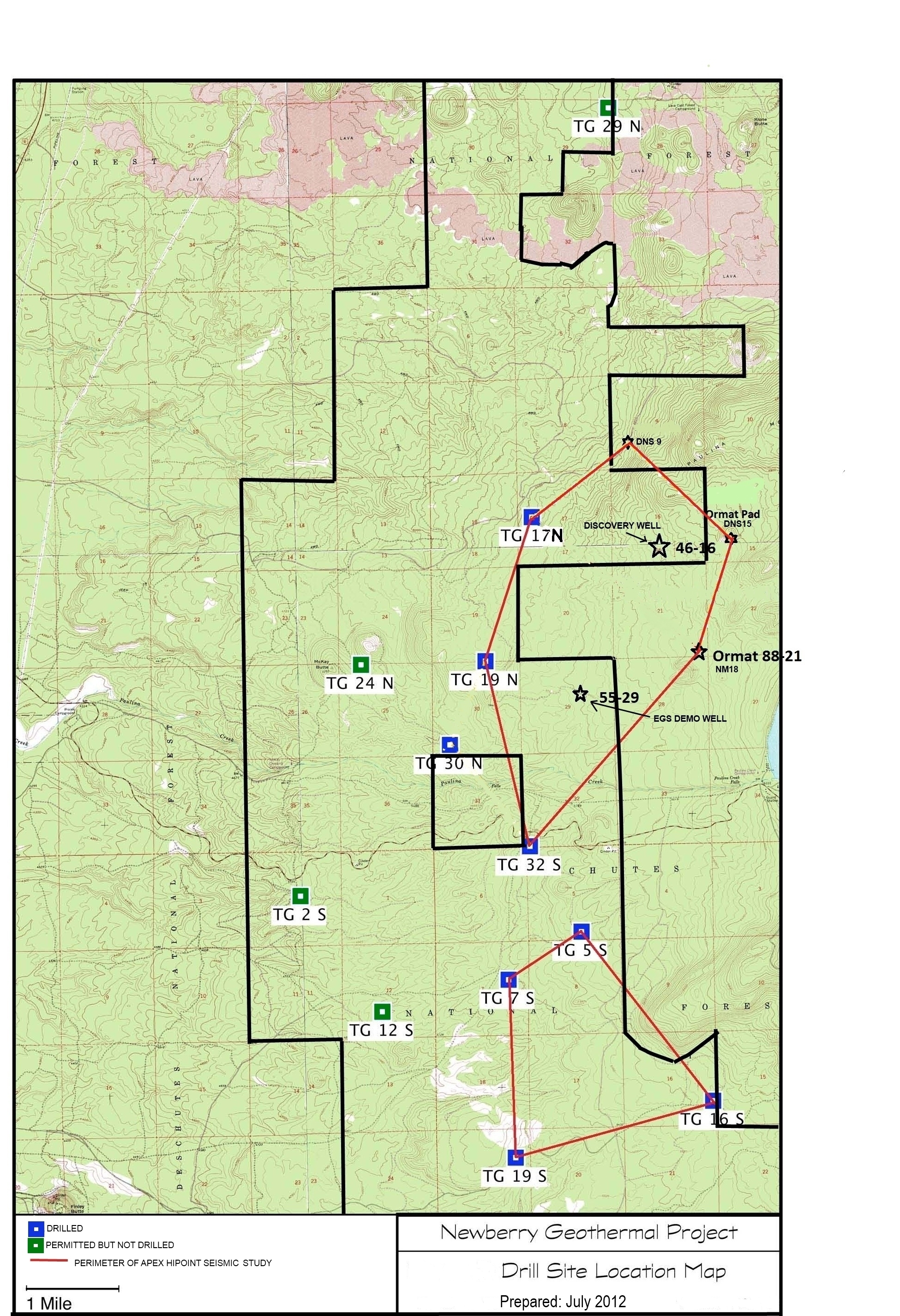
Map of Validation of Innovative Exploration Technologies for Newberry Volcano
Department of Energy —
A map showing location of wells permitted, drilled and seismic test, as part of validation of innovative exploration technologies done for the Newberry Volcano... -
Federal
Potential Wetland Extent Along the White River Between USGS Gaging Stations 03357000 and 03374100
Department of the Interior —
The Wetland Reserve Program (WRP) is a voluntary program administered by the NRCS. It provides technical and financial assistance to private landowners and Tribes to...
87 datasets found