
-
Federal
U.S. Climate Risk Projections by County, 2040-2049
National Aeronautics and Space Administration —
The U.S. Climate Risk Projections by County, 2040-2049 data set contains a projection for 2040-2049 risk for the entire contiguous U.S. at the county level with a... -
Federal
NASA Earth Observatory Images
National Aeronautics and Space Administration —
The Earth Observatory is part of the EOS Project Science Office located at NASA Goddard Space Flight Center. -
Federal
Global Flood Hazard Frequency and Distribution
National Aeronautics and Space Administration —
The Global Flood Hazard Frequency and Distribution is a 2.5 minute grid derived from a global listing of extreme flood events between 1985 and 2003 (poor or missing... -
Federal
Tree Mortality from Fires and Bark Beetles at 1-km Resolution, Western USA, 2003-2012
National Aeronautics and Space Administration —
This dataset provides annual estimates of tree mortality due to fires and bark beetles from 2003 to 2012 on forestland in the continental western United States. Tree... -
Federal
Global Landslide Hazard Distribution
National Aeronautics and Space Administration —
The Global Landslide Hazard Distribution is a 2.5 minute grid of global landslide and snow avalanche hazards based upon work of the Norwegian Geotechnical Institute... -
Federal
Climate History Extensions
U.S. Environmental Protection Agency —
This feature class contains yearly (2000-2019) natural hazard exposure estimates (percent area) at the county-level for the entire US (including AK, HI, and PR).... -
Federal
Global Earthquake Proportional Economic Loss Risk Deciles
National Aeronautics and Space Administration —
The Global Earthquake Proportional Economic Loss Risk Deciles is a 2.5 minute grid of earthquake hazard economic loss as proportions of Gross Domestic Product (GDP)... -
Federal
BLM Natl Areas of Critical Environmental Concern
Department of the Interior —
This polygon feature class contains BLM Designated Areas of Critical Environmental Concern (ACECs) polygons. These define areas within the public lands where special... -
Federal
Secondary data for study on the Impact of Hurricane Katrina on Southern Louisiana
U.S. Environmental Protection Agency —
Only secondary data was used for this study on the impact of Hurricane Katrina on Southern Louisiana The data sets include: land-cover data for Louisiana, social and... -
Federal
Climiate Resilience Screening Index and Domain Scores
U.S. Environmental Protection Agency —
CRSI and related-domain scores for all 50 states and 3135 counties in the U.S. This dataset is not publicly accessible because: They are already available within the... -
Federal
Global Earthquake Hazard Frequency and Distribution
National Aeronautics and Space Administration —
The Global Earthquake Hazard Frequency and Distribution is a 2.5 minute grid utilizing Advanced National Seismic System (ANSS) Earthquake Catalog data of actual... -
Federal
Global Earthquake Hazard Distribution - Peak Ground Acceleration
National Aeronautics and Space Administration —
The Global Earthquake Hazard Distribution - Peak Ground Acceleration is a 2.5 minute grid of global earthquake hazards developed using Global Seismic Hazard Program... -
Federal
Global Drought Proportional Economic Loss Risk Deciles
National Aeronautics and Space Administration —
The Global Drought Proportional Economic Loss Risk Deciles is a 2.5 minute grid of drought hazard economic loss as proportions of Gross Domestic Product (GDP) per... -
Federal
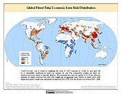
Global Flood Total Economic Loss Risk Deciles
National Aeronautics and Space Administration —
The Global Flood Total Economic Loss Risk Deciles is a 2.5 minute grid of global flood total economic loss risks. A process of spatially allocating Gross Domestic... -
Federal
Global Landslide Mortality Risks and Distribution
National Aeronautics and Space Administration —
The Global Landslide Mortality Risks and Distribution is a 2.5 minute grid of global landslide mortality risks. Gridded Population of the World, Version 3 (GPWv3)... -
Federal
Distribution of large boulders on the deposit of the West Salt Creek rock avalanche, western Colorado
Department of the Interior —
On May 25th, 2014, a 54.5 Mm3 rock avalanche occurred in the West Salt Creek valley in western Colorado following heavy rainfall on top of snow (Coe and others,... -
Federal
Global Drought Total Economic Loss Risk Deciles
National Aeronautics and Space Administration —
The Global Drought Total Economic Loss Risk Deciles is a 2.5 minute grid of global drought total economic loss risks. A process of spatially allocating Gross Domestic... -
Federal
BLM Natl Historic Areas of Critical Environmental Concern
Department of the Interior —
This dataset represents the BLM Historical Areas of Critical Environmental Concern polygon feature class. The BLM Historical Areas of Critical Environmental Concern... -
Federal
Annual Global High-Resolution Extreme Heat Estimates (GEHE), 1983-2016
National Aeronautics and Space Administration —
The Annual Global High-Resolution Extreme Heat Estimates (GEHE), 1983-2016 data set provides global 0.05 degrees (~5 km) gridded annual counts of the number of days...

Official websites use .gov
A
.gov website belongs to an official government
organization in the United States.
Secure .gov websites use HTTPS
A
lock (
) or https:// means you’ve safely connected to
the .gov website. Share sensitive information only on official,
secure websites.