
-
Federal
Underway physical, meteorological, chemical, and other data collected aboard numerous ships in the NOAA fleet in seas world-wide since February 2012
National Oceanic and Atmospheric Administration, Department of Commerce —
This collection contains underway physical, meteorological, chemical, and other datasets logged by the Scientific Computer System (SCS) aboard ships in the NOAA fleet... -
Federal
Physical, chemical, and biological water quality monitoring data to support detection of Harmful Algal Blooms (HABs) in western Lake Erie, collected by the Great Lakes Environmental Research Laboratory and the Cooperative Institute for Great Lakes Research since 2012
National Oceanic and Atmospheric Administration, Department of Commerce —
Blooms of nuisance and toxic cyanobacteria, referred to as cyanobacteria harmful algal blooms (cHABs), occur annually in Lake Erie and pose a threat to human health,... -
Federal
NOAA Office for Coastal Management Coastal Digital Elevation Model: Lake Erie
National Oceanic and Atmospheric Administration, Department of Commerce —
These data were created as part of the National Oceanic and Atmospheric Administration Office for Coastal Management's efforts to create an online mapping viewer... -
Federal
Total microcystins, chlorophyll, and other water quality data collected in Lake Erie from 2013-06-18 to 2024-10-22 (NCEI Accession 0276941)
National Oceanic and Atmospheric Administration, Department of Commerce —
Water sample data collected and curated by Ohio State University's Stone Laboratory and others between 2013 and 2024 in Lake Erie. The samples were collected in part... -
Federal
Experimental Harmful Algal Bloom (HAB) bulletin forecast products and associated satellite imagery from Lake Erie from 2008-09-04 to 2016-11-01 created by the NOAA National Centers for Coastal Ocean Science
National Oceanic and Atmospheric Administration, Department of Commerce —
This collection contains inputs to, and outputs from the NOAA Harmful Algal Bloom (HAB) Experimental Forecast for Lake Erie in the form of bulletin documents and... -
Federal
Forecast products and associated satellite imagery from Lake Erie created by the NOAA Harmful Algal Bloom Operational Forecast System (HAB-OFS) from 2017-06-25 to present
National Oceanic and Atmospheric Administration, Department of Commerce —
This archive information package contains inputs to, and outputs from the NOAA Harmful Algal Bloom Operational Forecast System (HAB-OFS) for the Lake Erie region in... -
Federal
Salinity, temperature, and other data collected aboard NOAA Ship FERREL and other platforms from 1996-01-30 to 1999-01-26 (NCEI Accession 9900157)
National Oceanic and Atmospheric Administration, Department of Commerce —
This dataset is a collection of cruise data collected by the Coastal Remote Sensing (CRS) Program at the NOAA Coastal Services Center (CSC). The data include CTD... -
Federal
NOAA Office for Coastal Management (OCM) Lake Level Data: Mapping Confidence
National Oceanic and Atmospheric Administration, Department of Commerce —
These data were created as part of the National Oceanic and Atmospheric Administration Office for Coastal Management's efforts to create an online mapping viewer... -
Federal
GL_StClair_Detroit_River 2019 ESI HYDRO Polygons, Lines
National Oceanic and Atmospheric Administration, Department of Commerce —
The feature classes HYDROL and HYDROP contain vector lines and polygons representing the coastal shoreline and hydrography used in the creation of the Environmental... -
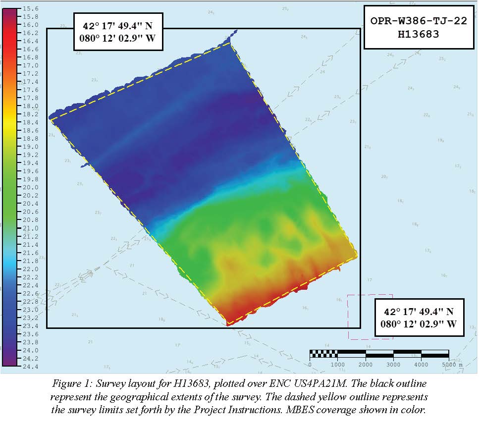
Federal
H13683: NOS Hydrographic Survey , 2022-08-14
National Oceanic and Atmospheric Administration, Department of Commerce —
The National Oceanic and Atmospheric Administration (NOAA) has the statutory mandate to collect hydrographic data in support of nautical chart compilation for safe... -
Federal
GL_LAKE_ERIE_2022 ESI HYDRO Polygons, Lines
National Oceanic and Atmospheric Administration, Department of Commerce —
The feature classes HYDROL and HYDROP contain vector lines and polygons representing the coastal shoreline and hydrography used in the creation of the Environmental... -
Federal
F00864: NOS Hydrographic Survey , 2022-08-17
National Oceanic and Atmospheric Administration, Department of Commerce —
The National Oceanic and Atmospheric Administration (NOAA) has the statutory mandate to collect hydrographic data in support of nautical chart compilation for safe... -
Federal
NOAA National Estuarine Research Reserve (NERR) System-wide Monitoring Program (SWMP) Meteorological, Water Quality and Nutrient/Pigment Data from 1994 to 2024
National Oceanic and Atmospheric Administration, Department of Commerce —
The NOAA National Estuarine Research Reserve (NERR) System-wide Monitoring Program (SWMP) collects meteorological, water quality, and nutrient/pigment data on an... -
Federal
Hyperspectral imagery to study harmful algal blooms (HABs) of Lake Erie, Lake St. Clair, and Saginaw Bay, Lake Huron of the Great Lakes region
National Oceanic and Atmospheric Administration, Department of Commerce —
The hyperspectral images in this collection contain flights over the western basin of Lake Erie, and Saginaw Bay, Lake Huron of the Great Lakes region during the HAB... -
Federal
GL_LAKE_ERIE_2022 ESI NAVIGATIONAL/MARINE Points
National Oceanic and Atmospheric Administration, Department of Commerce —
This feature class resides within the SOCECON Feature Data Set of the Lake Erie 2022 ESI Geodatabase. It contains vector points representing Navigational/marine... -
Federal
Shoreline Mapping Program of LAKE ERIE, PORT CLINTON TO HURON, OH, OH0906C NGDA
National Oceanic and Atmospheric Administration, Department of Commerce —
These data provide an accurate high-resolution shoreline compiled from imagery of LAKE ERIE, PORT CLINTON TO HURON, OH . This vector shoreline data is based on an... -
Federal
GL_StClair_Detroit_River 2019 ESI POLITICAL/JURISDICTIONAL Polygons
National Oceanic and Atmospheric Administration, Department of Commerce —
This feature class resides within the SOCECON Feature Data Set of the Great Lakes - St. Clair / Detroit River System 2019 ESI geodatabase. It contains vector polygons... -
Federal
Shoreline Mapping Program of LAKE ERIE, DETROIT RIVER TO PORT CLINTON, MI-OH, OH0906B NGDA
National Oceanic and Atmospheric Administration, Department of Commerce —
These data provide an accurate high-resolution shoreline compiled from imagery of LAKE ERIE, DETROIT RIVER TO PORT CLINTON, MI-OH . This vector shoreline data is... -
Federal
Shoreline Data Rescue Project of Lake Erie, West End, Ohio - Michigan, CM-7603 NGDA
National Oceanic and Atmospheric Administration, Department of Commerce —
These data were automated to provide an accurate high-resolution historical shoreline of Lake Erie, West End, Ohio - Michigan suitable as a geographic information... -
Federal
GL_StClair_Detroit_River 2019 ESI SOCECON Polygons, Lines, Points
National Oceanic and Atmospheric Administration, Department of Commerce —
These feature classes reside within the SOCECON Feature Data Set of the Great Lakes - St. Clair / Detroit River System 2019 ESI geodatabase. They contain vector...

Official websites use .gov
A
.gov website belongs to an official government
organization in the United States.
Secure .gov websites use HTTPS
A
lock (
) or https:// means you’ve safely connected to
the .gov website. Share sensitive information only on official,
secure websites.