
-
Federal
Quality-controlled sea surface marine physical, meteorological and other in situ measurements from the NCEI Surface Underway Marine Database (NCEI-SUMD)
National Oceanic and Atmospheric Administration, Department of Commerce —
This collection contains global in-situ sea surface underway measurements from the NOAA NCEI Surface Underway Marine Database (NCEI-SUMD, formerly the NCEI... -
Federal
AFSC/RACE/SAP/Foy: Effects of ocean acidification on larval Tanner crab: Kodiak Island, Alaska.
National Oceanic and Atmospheric Administration, Department of Commerce —
To study the effects of ocean acidification we examined the effects of ocean acidification on the larval stages of the economically important southern Tanner crab,... -
State
Updated tsunami inundation maps of the Kodiak area, Alaska
State of Alaska —
Staff from Alaska Earthquake Center, Geophysical Institute and Alaska Division of Geological & Geophysical Surveys evaluated potential potential tsunami hazard... -
Federal
H06829: NOS Hydrographic Survey , 1947-07-22
National Oceanic and Atmospheric Administration, Department of Commerce —
The National Oceanic and Atmospheric Administration (NOAA) has the statutory mandate to collect hydrographic data in support of nautical chart compilation for safe... -
Federal
AFSC/RACE/FBEP/Laurel: Effects of natural and anthropogenic disturbance on polychaete worm tubes and age-0 flatfish distribution
National Oceanic and Atmospheric Administration, Department of Commerce —
This dataset is from a field experiment that examined how juvenile flatfish distribution changed with worm tube heterogeneity, i.e. density and patchiness. -
Federal
H13105: NOS Hydrographic Survey , 2019-06-20
National Oceanic and Atmospheric Administration, Department of Commerce —
The National Oceanic and Atmospheric Administration (NOAA) has the statutory mandate to collect hydrographic data in support of nautical chart compilation for safe... -
Federal
TIGER/Line Shapefile, 2022, County, Kodiak Island Borough, AK, Address Range-Feature Name Relationship File
U.S. Census Bureau, Department of Commerce —
The TIGER/Line shapefiles and related database files (.dbf) are an extract of selected geographic and cartographic information from the U.S. Census Bureau's Master... -
Federal
H10032: NOS Hydrographic Survey , St. Paul Harbor, Kodiak, Alaska, 1983-07-30
National Oceanic and Atmospheric Administration, Department of Commerce —
The National Oceanic and Atmospheric Administration (NOAA) has the statutory mandate to collect hydrographic data in support of nautical chart compilation for safe... -
Federal
Chiniak, Alaska 8/15 arc-second Coastal Digital Elevation Model
National Oceanic and Atmospheric Administration, Department of Commerce —
NOAA's National Centers for Environmental Information is building high-resolution digital elevation models (DEMs) to support individual coastal States as part of the... -
Federal
AFSC/RACE/FBEP/Laurel: Substrate preference and delayed settlement in northern rock sole larvae Lepidopsetta polyxystra
National Oceanic and Atmospheric Administration, Department of Commerce —
This dataset is from laboratory experiments testing the onset and ontogenetic changes in habitat selection of pre- and post-settling northern rock sole (NRS) larvae,... -
Federal
TIGER/Line Shapefile, 2022, County, Kodiak Island Borough, AK, Address Range-Feature
U.S. Census Bureau, Department of Commerce —
The TIGER/Line shapefiles and related database files (.dbf) are an extract of selected geographic and cartographic information from the U.S. Census Bureau's Master... -
Federal
F00289: NOS Hydrographic Survey , Southern Alaska Peninsula, Alaska, 1986-09-03
National Oceanic and Atmospheric Administration, Department of Commerce —
The National Oceanic and Atmospheric Administration (NOAA) has the statutory mandate to collect hydrographic data in support of nautical chart compilation for safe... -
Federal
Shoreline Mapping Program of KODIAK ISLAND, TANNER HEAD TO SITKALIDAK STRAIT, AK, AK0603A NGDA
National Oceanic and Atmospheric Administration, Department of Commerce —
These data provide an accurate high-resolution shoreline compiled from imagery of KODIAK ISLAND, TANNER HEAD TO SITKALIDAK STRAIT, AK . This vector shoreline data is... -
Federal
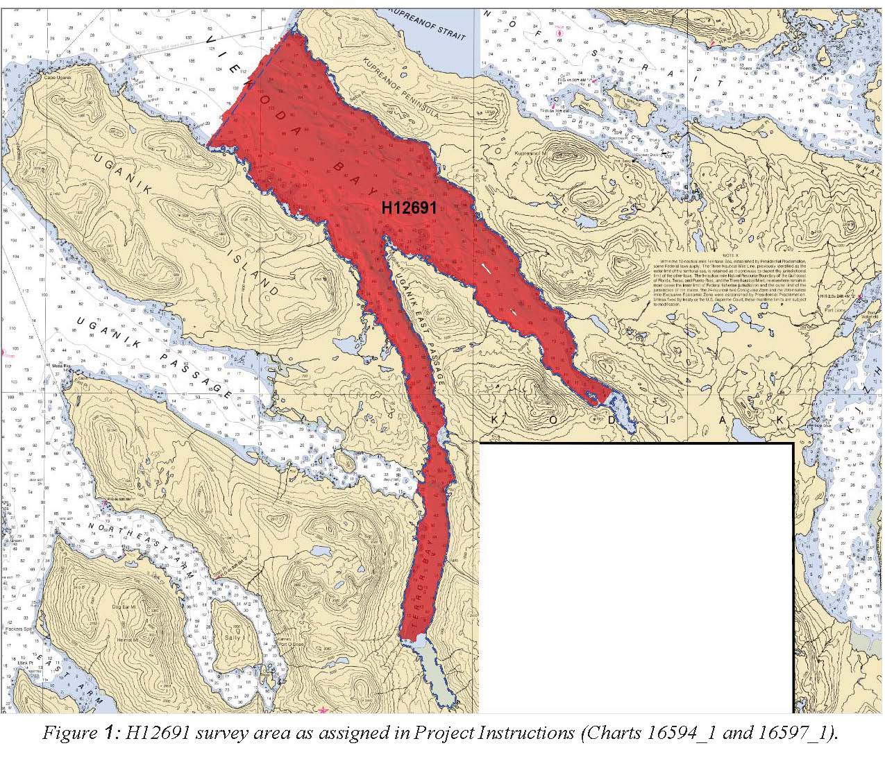
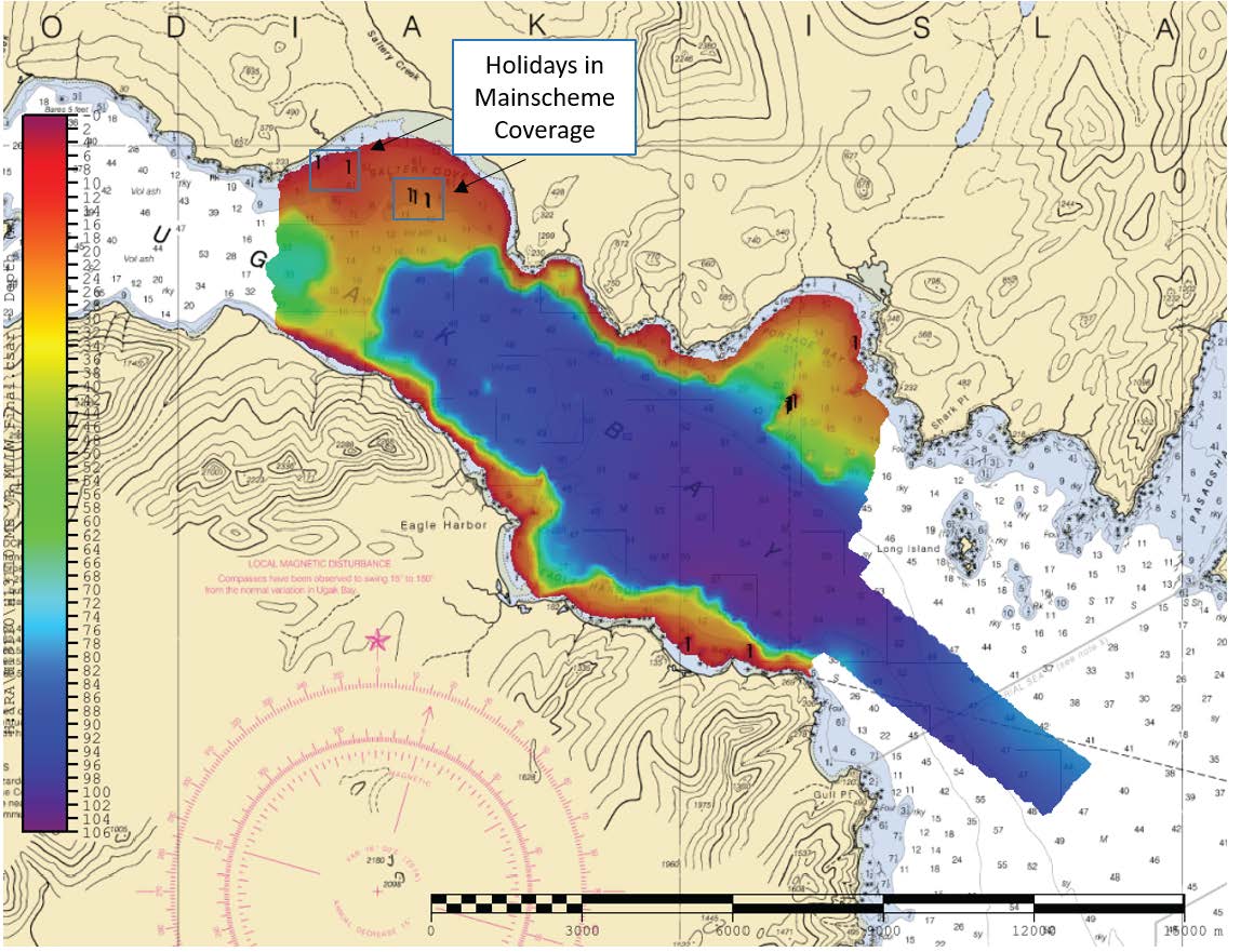
H12691: NOS Hydrographic Survey , 2015-10-21
National Oceanic and Atmospheric Administration, Department of Commerce —
The National Oceanic and Atmospheric Administration (NOAA) has the statutory mandate to collect hydrographic data in support of nautical chart compilation for safe... -
Federal
H13110: NOS Hydrographic Survey , 2019-06-21
National Oceanic and Atmospheric Administration, Department of Commerce —
The National Oceanic and Atmospheric Administration (NOAA) has the statutory mandate to collect hydrographic data in support of nautical chart compilation for safe... -
Federal
H13108: NOS Hydrographic Survey , 2019-07-28
National Oceanic and Atmospheric Administration, Department of Commerce —
The National Oceanic and Atmospheric Administration (NOAA) has the statutory mandate to collect hydrographic data in support of nautical chart compilation for safe... -
Federal
AFSC/RACE/FBEP/Ryer: Depth distribution, habitat associations, and differential growth of newly settled southern Tanner crab (Chionoecetes bairdi) in embayments around Kodiak Island, Alaska
National Oceanic and Atmospheric Administration, Department of Commerce —
This dataset is from field surveys that examined depth distribution, habitat association, and growth of newly settled Tanner crab at 4 sites around the eastern end of... -
Federal
TIGER/Line Shapefile, 2024, County, Kodiak Island Borough, AK, Topological Faces-Area Hydrography Relationship File
U.S. Census Bureau, Department of Commerce —
The TIGER/Line shapefiles and related database files (.dbf) are an extract of selected geographic and cartographic information from the U.S. Census Bureau's Master... -
Federal
Akhiok, Alaska 8/15 arc-second Coastal Digital Elevation Model
National Oceanic and Atmospheric Administration, Department of Commerce —
NOAA's National Centers for Environmental Information (NCEI) is building high-resolution digital elevation models (DEMs) to support individual coastal States as part... -
Federal
AFSC/RACE/SAP/Foy: Seawater chemistry of three pH treatments used to test the effect of pH on Tanner crab biology: Kodiak Island, Alaska.
National Oceanic and Atmospheric Administration, Department of Commerce —
To study the effects of ocean acidification we examined the effects of ocean acidification on the embryo and larval stages of the economically important southern...

Official websites use .gov
A
.gov website belongs to an official government
organization in the United States.
Secure .gov websites use HTTPS
A
lock (
) or https:// means you’ve safely connected to
the .gov website. Share sensitive information only on official,
secure websites.
.jpg)