

158 datasets found
-
Federal
NASA Earth Observatory Images
National Aeronautics and Space Administration —
The Earth Observatory is part of the EOS Project Science Office located at NASA Goddard Space Flight Center. -
Federal
NLM Digital Collections
U.S. Department of Health & Human Services —
The National Library of Medicine's (NLM) Digital Collections offers a search-based Web service that provides access to the Dublin Core metadata and full-text OCR of... -
Federal
Visible Human Project
U.S. Department of Health & Human Services —
The NLM Visible Human Project® has created publicly-available complete, anatomically detailed, three-dimensional representations of a human male body and a human... -
Federal
Computational Photography Project for Pill Identification (C3PI)
U.S. Department of Health & Human Services —
The Computational Photography Project for Pill Identification (C3PI) was sunset in 2018. No new images will be added to the collection. Identifiers for pills will not... -
Federal
Mars Rover Photos API
National Aeronautics and Space Administration —
This API is designed to collect image data gathered by NASA's Curiosity, Opportunity, and Spirit rovers on Mars and make it more easily available to other developers,... -
Federal
Multispectral aerial imagery collected during uncrewed aircraft systems (UAS) operations: Plum Island Estuary and Parker River NWR (PIEPR), Massachusetts, November 14, 2017 and March 28, 2019
Department of the Interior —
Low-altitude (80 and 100 meters above ground level) digital images were collected by the USGS Woods Hole Coastal and Marine Science Center (WHCMSC) Aerial Imaging and... -
Federal
NSF Multimedia Gallery
National Science Foundation —
NSF gallery containing links to multimedia files, including images and video, related to the National Science Foundation and its mission. -
Federal
Landsat 2000
National Aeronautics and Space Administration —
Landsat.org, an affiliate of the Tropical Rain Forest Information Center (TRFIC), now hosts the Global Orthorectified Landsat Datasets for four epochs: 1970's MSS,... -
Federal
SEG-Y format of chirp seismic-reflection profiles collected in Lake Mead in 1999
Department of the Interior —
Lake Mead is a large interstate reservoir located in the Mojave Desert of southeastern Nevada and northwestern Arizona. It was impounded in 1935 by the construction... -
Federal
Patent Application Full Text Data with Embedded TIFF Images (2001 - Present) (Application Red Book based on WIPO ST.36)
Department of Commerce —
Contains the full text, images/drawings, and complex work units (tables, mathematical expressions, chemical structures, and genetic sequence data) of each patent... -
Federal
NIST Structured Forms Reference Set of Binary Images II (SFRS2) - NIST Special Database 6
National Institute of Standards and Technology —
The documents in this database are 12 different tax forms with the IRS 1040 Package X for the year 1988. These include Forms 1040, 2106, 2441, 4562, and 6251 together... -
Federal
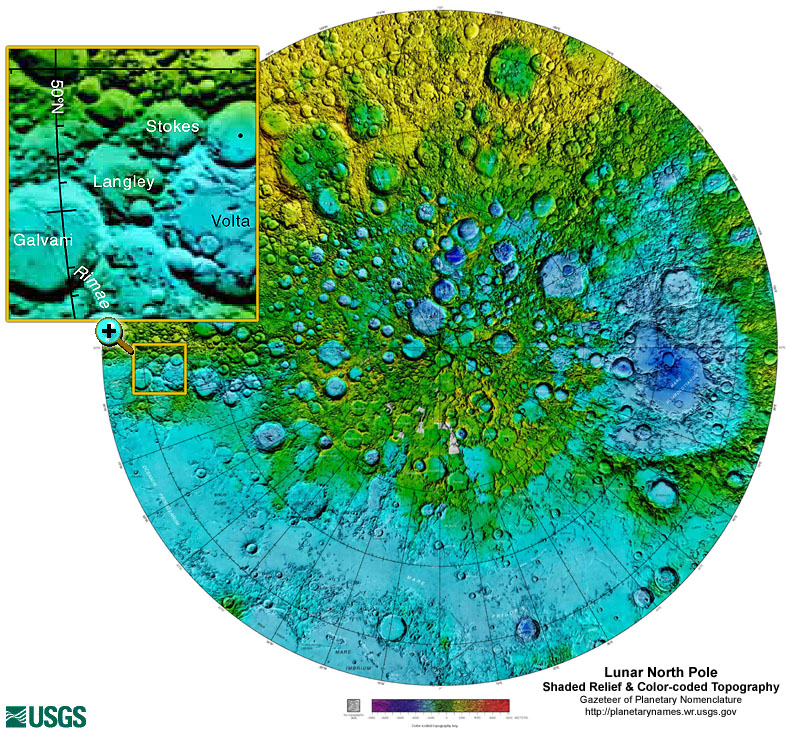
Gazetteer of Planetary Nomenclature: Moon: 1:10 million-scale Shaded Relief and Color-coded Topography: North Pole
National Aeronautics and Space Administration —
These lunar maps display the four different areas of the moon with color-coded topography in low and high resolution approved by the International Astronomical Union... -
Federal
Gazetteer of Planetary Nomenclature: Mars: 1:5 million-scale THEMIS Images
National Aeronautics and Space Administration —
THEMIS imagery of Mars approved by the International Astronomical Union (IAU). -
Federal
Surface Representing the Floor of Lake Mead and the surrounding area: UTM Projection 10m cellsize
Department of the Interior —
Lake Mead is a large interstate reservoir located in the Mojave Desert of southeastern Nevada and northwestern Arizona. It was impounded in 1935 by the construction... -
Federal
Gazetteer of Planetary Nomenclature: Mars: Phobos names with images and Deimos
National Aeronautics and Space Administration —
These images display the two moons of Mars: Deimos and Phobos - with HRSC images and shaded relief images with cylindrical and hemispherical views approved by the... -
Federal
Gazetteer of Planetary Nomenclature: Moon: 1:1 million-scale maps of the Moon
National Aeronautics and Space Administration —
The purpose of the lunar maps is to provide an up-to-date and comprehensive depiction on lunar nomenclature approved by the International Astronomical Union (IAU). -
Federal
Planetary Data System (PDS)
National Aeronautics and Space Administration —
The Planetary Data System (PDS) is an archive of data products from NASA planetary missions, which is sponsored by NASA's Science Mission Directorate. We actively...
158 datasets found