
-
Federal
CALIPSO Lidar Level 2 Aerosol Profile, V4-21
National Aeronautics and Space Administration —
CAL_LID_L2_05kmAPro-Standard-V4-21 is the Cloud-Aerosol Lidar and Infrared Pathfinder Satellite Observations (CALIPSO) Lidar Level 2 Aerosol Profile, Version 4-21... -
Federal
MERRA-2 tavg1_2d_aer_Nx: 2d,1-Hourly,Time-averaged,Single-Level,Assimilation,Aerosol Diagnostics 0.625 x 0.5 degree V5.12.4 (M2T1NXAER) at GES DISC
National Aeronautics and Space Administration —
M2T1NXAER (or tavg1_2d_aer_Nx) is an hourly time-averaged 2-dimensional data collection in Modern-Era Retrospective analysis for Research and Applications version 2... -
Federal
MISR Level 2 Aerosol parameters subset for the UAE region V002
National Aeronautics and Space Administration —
UAEMIAAE_002 is the Multi-angle Imaging spectro-radiometer (MISR). It contains aerosol optical depth, particle type, and associated atmospheric data. The MISR... -
Federal
CERES and GEO-Enhanced TOA, Within-Atmosphere and Surface Fluxes, Clouds and Aerosols Monthly Terra-Aqua Edition4A
National Aeronautics and Space Administration —
CER_SYN1deg-Month_Terra-Aqua-MODIS_Edition4A is the Clouds and the Earth's Radiant Energy System (CERES) and geostationary (GEO)-Enhanced Top of Atmosphere (TOA),... -
Federal
CERES Regionally Averaged TOA Fluxes, Clouds and Aerosols Hourly Terra Edition4A
National Aeronautics and Space Administration —
CER_SSF1deg-Hour_Terra-MODIS_Edition4A is the Clouds and the Earth's Radiant Energy System (CERES) Regionally Averaged Top of Atmosphere (TOA) Fluxes, Clouds and... -
Federal
DISCOVER-AQ Maryland Deployment P-3B Aircraft In Situ Aerosol Data
National Aeronautics and Space Administration —
DISCOVERAQ_Maryland_Aerosol_AircraftInSitu_P3B_Data contains in situ aerosol data collected onboard NASA's P-3B aircraft during the Maryland (Baltimore-Washington)... -
Federal
MISR Level 2 Aerosol parameters V003
National Aeronautics and Space Administration —
MIL2ASAE_3 is the Multi-angle Imaging SpectroRadiometer (MISR) Level 2 Aerosol parameters Version 3 product. It contains information on retrieved aerosol column... -
Federal
AHI/Himawari-08 Dark Target Aerosol 10-Min L2 Full Disk 10 km
National Aeronautics and Space Administration —
The AHI/Himawari-08 Dark Target Aerosol 10-Min L2 Full Disk 10 km product, short-name XAERDT_L2_AHI_H08 is provided at 10-km spatial resolution (at-nadir) and a... -
Federal
ARCTAS DC-8 Aircraft In-situ Aerosol Data
National Aeronautics and Space Administration —
ARCTAS_Aerosol_AircraftInSitu_DC8_Data is the in-situ aerosol data for the DC-8 aircraft collected during the Arctic Research of the Composition of the Troposphere... -
Federal
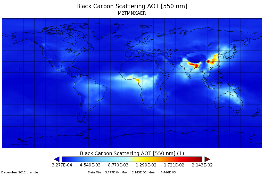
MERRA-2 tavgM_2d_aer_Nx: 2d,Monthly mean,Time-averaged,Single-Level,Assimilation,Aerosol Diagnostics 0.625 x 0.5 degree V5.12.4 (M2TMNXAER) at GES DISC
National Aeronautics and Space Administration —
M2TMNXAER (or tavgM_2d_aer_Nx) is a time-averaged 2-dimensional monthly mean data collection in Modern-Era Retrospective analysis for Research and Applications... -
Federal
SEAC4RS DC-8 Aircraft In-Situ Aerosol Data
National Aeronautics and Space Administration —
SEAC4RS_Aerosol_AircraftInSitu_DC8_Data are in-situ aerosol data collected onboard the DC8 aircraft during the Studies of Emissions and Atmospheric Composition,... -
Federal
SEAC4RS Merge Data Files
National Aeronautics and Space Administration —
SEAC4RS_Merge_Data are pre-generated merge data files collected during the Studies of Emissions and Atmospheric Composition, Clouds and Climate Coupling by Regional... -
Federal
MISR Derived Case Study Data for Iceland Volcanic Eruptions (Eyjafjallajokull, Grimsvotn, Holuhraun) Including Geometric Plume Height and Qualitative Radiometric Particle Property Information
National Aeronautics and Space Administration —
This dataset comprises MISR-derived output from a comprehensive analysis of Icelandic volcano eruptions (Eyjafjallajokull 2010, Grimsvotn 2011, Holuhraun 2014-2015).... -
Federal
CALIPSO Lidar Level 3 Stratospheric Aerosol Profiles Standard V1-01
National Aeronautics and Space Administration —
CAL_LID_L3_Stratospheric_APro-Standard-V1-01 is the Cloud-Aerosol Lidar and Infrared Pathfinder Satellite Observation (CALIPSO) Lidar Level 3 Stratospheric Aerosol... -
Federal
SOLVE I Supplementary Satellite Data Products
National Aeronautics and Space Administration —
SOLVE1_Satellite_Data is the supplementary satellite data for the SAGE III Ozone Loss and Validation Experiment (SOLVE). Data were collected by instruments such as... -
Federal
CERES Single Scanner Footprint (SSF) TOA/Surface Fluxes, Clouds and Aerosols NOAA20-FM6-VIIRS Edition1C
National Aeronautics and Space Administration —
CER_SSF_NOAA20-FM6-VIIRS_Edition1C is the NOAA-20 Single Scanner Footprint (SSF) Clouds and the Earth's Radiant Energy System (CERES) Level 2 observed Top of... -
Federal
FIREX-AQ DC-8 High-Spectral Resolution Lidar (HSRL) Remotely Sensed Data
National Aeronautics and Space Administration —
FIREXAQ_HSRL_AircraftRemoteSensing_DC8_Data are remotely sensed data collected by the High-Spectral Resolution Lidar (HSRL) onboard the DC-8 aircraft during FIREX-AQ.... -
Federal
AHI/Himawari-09 Dark Target Aerosol 10-Min L2 Full Disk 10 km
National Aeronautics and Space Administration —
The AHI/Himawari-09 Dark Target Aerosol 10-Min L2 Full Disk 10 km product, short-name XAERDT_L2_AHI_H09 is provided at 10-km spatial resolution (at-nadir) and a... -
Federal
CPEX-AW HALO Aerosol and Water Vapor Profiles and Images
National Aeronautics and Space Administration —
CPEXAW-HALO_DC8_1 is the High Altitude Lidar Observatory (HALO) image and h5 data files collected during the Convective Processes Experiment - Aerosols & Winds... -
Federal
PEM West B DC-8 Remotely Sensed Differential Absorption Lidar (DIAL) Data
National Aeronautics and Space Administration —
PEM-West-B_AircraftRemoteSensing_DC8_DIAL_Data is the remotely sensed Differential Absorption Lidar (DIAL) data collected onboard the DC-8 aircraft during the Pacific...

Official websites use .gov
A
.gov website belongs to an official government
organization in the United States.
Secure .gov websites use HTTPS
A
lock (
) or https:// means you’ve safely connected to
the .gov website. Share sensitive information only on official,
secure websites.