

38 datasets found
-
Federal
Sea level measured by tide gauges from global oceans as part of the Joint Archive for Sea Level (JASL) since 1846
National Oceanic and Atmospheric Administration, Department of Commerce —
This collection contains the complete holdings of the Joint Archive for Sea Level (JASL) for hourly and daily data that have been quality controlled, assessed, and... -
State
Stratigraphic and electron microprobe data for Holocene tephra from Makushin Volcano, Alaska, and for interbedded tephra from other volcanoes located among or near the islands of the eastern Aleutians
State of Alaska —
Stratigraphic and electron microprobe data for Holocene tephra from Makushin Volcano, Alaska, and for interbedded tephra from other volcanoes located among or near... -
Federal
Snake River Plain FORGE: Site Characterization Data
Department of Energy —
The site characterization data used to develop the conceptual geologic model for the Snake River Plain site in Idaho, as part of phase 1 of the Frontier Observatory... -
Federal
Validation of Innovative Exploration Technologies for Newberry Volcano: Raw Seismic Data
Department of Energy —
Validation of Innovative Exploration Technologies for Newberry Volcano: Seismic data - raw taken by Apex Hipoint for 1st test 2012 (data in .ff format) -
Federal
Digital Geologic and Volcanic Hazards Map for Crater Lake National Park and Vicinity, Oregon (NPS, GRD, GRI, CRLA, CLHZ digital map)
Department of the Interior —
The Digital Geologic and Volcanic Hazards Map for Crater Lake National Park and Vicinity, Oregon is composed of GIS data layers complete with ArcMap 9.3 layer (.LYR)... -
State
Geology of Kasatochi volcano, Aleutian Islands, Alaska
State of Alaska —
Geology of Kasatochi volcano, Aleutian Islands, Alaska, Professional Report 123, shows the distribution of post-2008 volcanic rocks, other uncolidated deposits, and... -
State
Geologic map of Okmok Volcano
State of Alaska —
Geologic map of Okmok Volcano, Report of Investigation 2023-1, shows the distribution of historic, Holocene, and late Pleistocene volcanic rocks and deposits related... -
State
The 2008 phreatomagmatic eruption of Okmok Volcano, Aleutian Islands, Alaska: Chronology, deposits, and landform changes
State of Alaska —
Okmok volcano, Aleutian Islands, Alaska, explosively erupted over a five-week period between July 12 and August 23, 2008. The eruption was predominantly... -
Federal
Validation of Innovative Exploration Technologies for Newberry Volcano: Lithology Reports of TGWs
Department of Energy —
Validation of Innovative Exploration Technologies for Newberry Volcano: Lithology Reports of Temperature Gradient Wells -
Federal
Validation of Innovative Exploration Technologies for Newberry Volcano: Drilling Summary
Department of Energy —
Drilling summary from validation of innovative exploration technologies for Newberry Volcano, including depths, dates, and drilling statistics from 2012 -
State
Geologic map of Okmok Volcano
State of Alaska —
Geologic map of Okmok Volcano, Report of Investigation 2023-1, provides 40Ar/39Ar and radiocarbon geochronology data from Okmok Volcano and its eruptive products.... -
Federal
Validation of Innovative Exploration Technologies for Newberry Volcano: Geochemistry Data from Wells 55-29 and 46-16
Department of Energy —
Validation of Innovative Exploration Technologies for Newberry Volcano: DOE Geochemistry data from deep wells 55-29 and 46-16 at Newberry 2012 -
Federal
NASA GIFT Iceland Highlands: 2019 and 2021 Askja Ground Penetrating Radar (GPR) and Observations
Department of the Interior —
This data collection includes ground-penetrating radar (GPR) data and related observations collected from the NASA Goddard Instrument Field Team (GIFT) Expedition to... -
Federal
NASA GIFT Iceland Highlands: 2019 Oskjuvatn LiDAR
Department of the Interior —
LiDAR scans were taken using a tripod mounted Riegl VZ-400 scanning LiDAR. The tripod was set up such that the scanner was between 1.5 and 2.5 m tall. The VZ-400 is a... -
Federal
Database for the geologic map of the Paeroa Fault block and surrounding area, Taupo Volcanic Zone, New Zealand
Department of the Interior —
The Taupo Volcanic Zone (TVZ), New Zealand, is the most productive area of explosive silicic volcanism in the world. Faulted early and middle Pleistocene volcanic... -
Federal
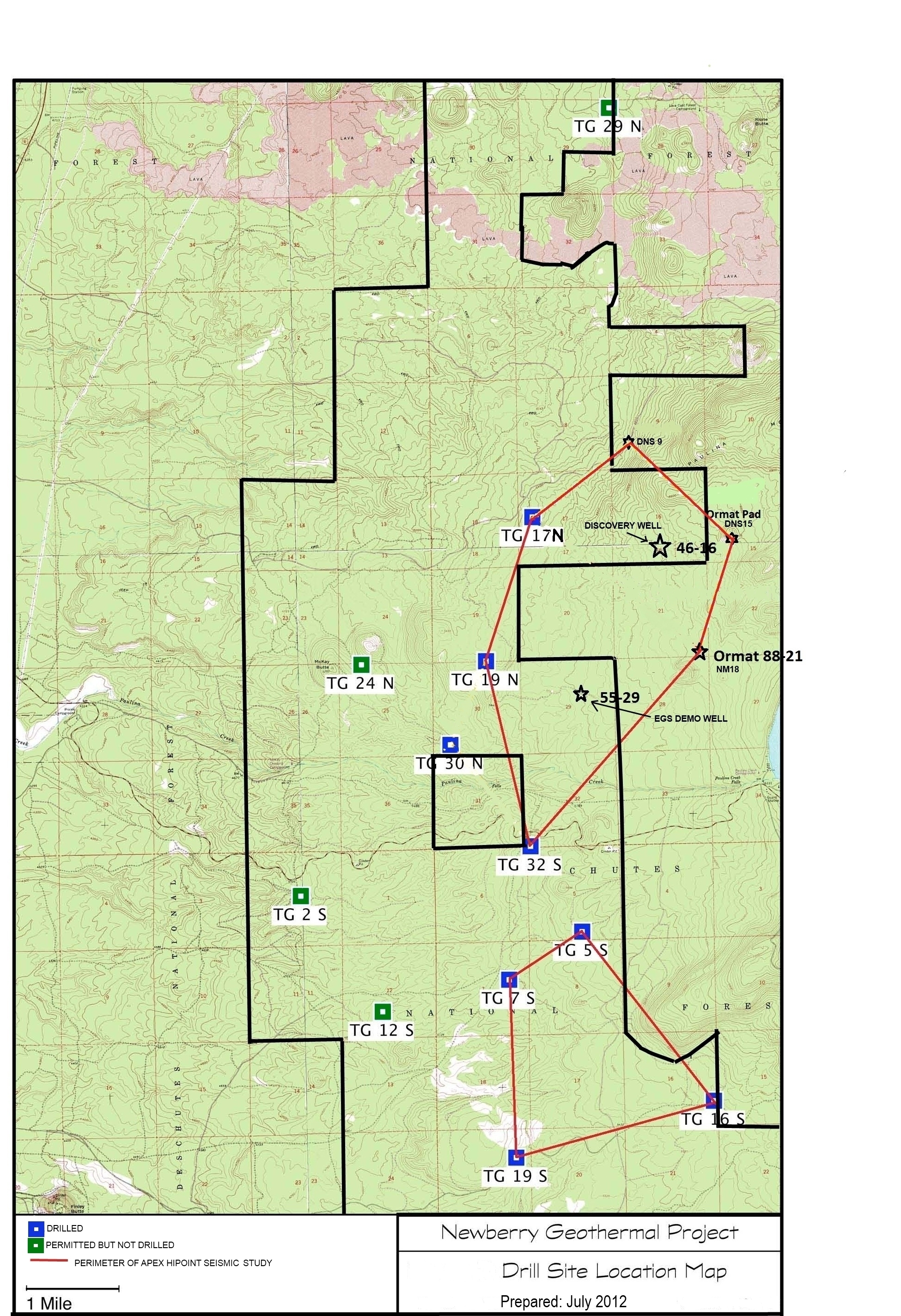
Map of Validation of Innovative Exploration Technologies for Newberry Volcano
Department of Energy —
A map showing location of wells permitted, drilled and seismic test, as part of validation of innovative exploration technologies done for the Newberry Volcano... -
Federal
Geothermal Case Studies on OpenEI
Department of Energy —
This submission contains links to Geothermal Areas on OpenEI that were completed as part of an effort to gather clean, unbiased information on which to build... -
State
Geologic map of the Makushin volcanic field, Unalaska Island, Alaska
State of Alaska —
Report of Investigation 97-20, Geologic map of the Makushin volcanic field, Unalaska Island, Alaska, covers most of the north end of Unalaska Island, which is the... -
State
Previously unpublished whole-rock major- and trace-element compositions of volcanic samples from the Alaska Peninsula-Aleutian arc, Alaska
State of Alaska —
Previously unpublished whole-rock major- and trace-element compositions of volcanic samples from the Alaska Peninsula-Aleutian arc, Alaska, Raw Data File 2025-2,... -
Federal
Newberry Caldera Conceptual Geophysical Model
Department of Energy —
Conceptual model for the Newberry Caldera geothermal area. Model is centered around caldera and evaluates multiple geophysical datasets to derive a conceptual...
38 datasets found