-
Federal
CRED 5 m Gridded bathymetry of Jarvis Island, Pacific Remote Island Areas, Central Pacific (NetCDF Format)
National Oceanic and Atmospheric Administration, Department of Commerce —
Gridded (5 m cell size) bathymetry of the shelf and slope environments of Jarvis Island, Pacific Remote Island Areas, Central Pacific. Almost complete bottom coverage... -
Federal
Bathymetric Position Index (BPI) Zones 10 m grid derived from gridded bathymetry of Wake Island, West Central Pacific.
National Oceanic and Atmospheric Administration, Department of Commerce —
BPI Zones are derived from a focal mean analysis on bathymetry and slope. The grid is based on gridded (10 m cell size) multibeam bathymetry, collected aboard R/V AHI... -
Federal
CRED Reson 8101 multibeam backscatter data from the banktop and bank edge environments of Ofu, Olosega, and Ta'u Islands of the Manua Island group, American Samoa with 1 meter resolution in netCDF format
National Oceanic and Atmospheric Administration, Department of Commerce —
Multibeam backscatter imagery extracted from gridded bathymetry of Ofu, Olosega, and Ta'u Islands of the Manua Island Group, American Samoa, South Pacific. These data... -
Federal
10 m Rugosity grid derived from gridded bathymetry of Wake Island, West Central Pacific.
National Oceanic and Atmospheric Administration, Department of Commerce —
Rugosity is derived from gridded (10 m cell size) multibeam bathymetry, collected aboard NOAA ship Hi'ialakai and R/V AHI using the Benthic Terrain Modeler with... -
Federal
CRED Simrad em3002d multibeam backscatter data from the banktop and bank edge environments at Tutuila, American Samoa, South Pacific with 1 meter resolution in GeoTIFF format
National Oceanic and Atmospheric Administration, Department of Commerce —
Multibeam backscatter imagery extracted from gridded bathymetry of Tutuila, American Samoa, South Pacific These data provide coverage between 20 and 5000 meters. The... -
Federal
CRED 20 m Gridded bathymetry of Kingman Reef, Pacific Remote Island Areas, Central Pacific (Arc ASCII Format)
National Oceanic and Atmospheric Administration, Department of Commerce —
Gridded (20 m cell size) bathymetry of the lagoon, shelf and slope environments of Kingman Reef, Pacific Remote Island Areas, Central Pacific. Almost complete bottom... -
Federal
Bathymetric Position Index (BPI) Structures 5 m grid derived from gridded bathymetry of Ta'u Island, Territory of American Samoa, USA.
National Oceanic and Atmospheric Administration, Department of Commerce —
BPI Structures are derived from two scales of a focal mean analysis on bathymetry and slope. The grid is based on gridded (5 m cell size) multibeam bathymetry,... -
Federal
2006 Reson 8101ER Multibeam Sonar Data from Cruise AHI-06-01 - Pacific Remote Island Areas
National Oceanic and Atmospheric Administration, Department of Commerce —
Reson 8101ER multibeam Data were collected from 15 Jan - 6 Feb aboard NOAA Survey Launch Acoustic Habitat Investigator (AHI) at Johnston Island, Howland Island, and... -
Federal
Gridded bathymetry of the banktop and slope environments of Ta'u Island of the Manu'a Island group, American Samoa (Arc ASCII format)
National Oceanic and Atmospheric Administration, Department of Commerce —
Gridded bathymetry of the banktop and slope environments of Ta'u Island of the Manu'a Island group, American Samoa. This survey provides almost complete coverage... -
Federal
Mosaic of gridded multibeam bathymetry and bathymetry derived from multispectral IKONOS satellite imagery of Kingman Reef, Pacific Remote Island Area, USA
National Oceanic and Atmospheric Administration, Department of Commerce —
Gridded multibeam bathymetry is integrated with bathymetry derived from multispectral IKONOS satellite data. Gridded (5 m cell size) multibeam bathymetry collected... -
Federal
CRED Optical Validation Data at the islands of Ofu and Olosega in American Samoa, 2004 to Support Benthic Habitat Mapping (TOAD)
National Oceanic and Atmospheric Administration, Department of Commerce —
Optical validation data were collected using a Tethered Optical Assessment Device (TOAD), an underwater sled equipped with an underwater digital video camera and... -
Federal
CRED 20 m Gridded bathymetry of Jarvis Island, Pacific Remote Island Areas, Central Pacific (Arc ASCII Format)
National Oceanic and Atmospheric Administration, Department of Commerce —
Gridded (20 m cell size) bathymetry of the shelf and slope environments of Jarvis Island, Pacific Remote Island Areas, Central Pacific. Almost complete bottom... -
Federal
CRED 5 m Gridded bathymetry of Palmyra Atoll, Pacific Remote Island Areas, Central Pacific (NetCDF Format)
National Oceanic and Atmospheric Administration, Department of Commerce —
Gridded (5 m cell size) bathymetry of the lagoon, shelf and slope environments of Palmyra Atoll, Pacific Remote Island Areas, Central Pacific. Almost complete bottom... -
Federal
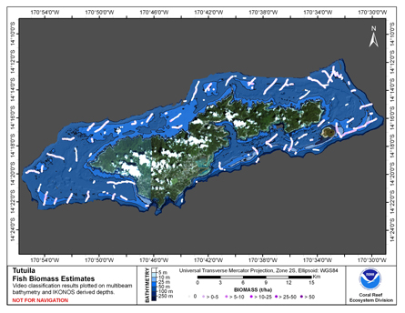
CRED Cumulative Fish Biomass map at Tutuila Island
National Oceanic and Atmospheric Administration, Department of Commerce —
This map displays fish biomass observation locations overlaid on bathymetry. -
Federal
Gridded bathymetry of Tutuila Island, American Samoa, South Pacific
National Oceanic and Atmospheric Administration, Department of Commerce —
Gridded (5 m cell size) bathymetry of the shelf and slope environments of Tutuila Island, American Samoa, South Pacific. Almost complete bottom coverage was achieved... -
Federal
CRED Reson 8101 multibeam backscatter data from the banktop and bank edge environments at Tutuila, American Samoa, South Pacific with 1 meter resolution in GeoTIFF format
National Oceanic and Atmospheric Administration, Department of Commerce —
Multibeam backscatter imagery extracted from gridded bathymetry of Tutuila, American Samoa, South Pacific These data provide coverage between 20 and 5000 meters. The... -
Federal
CRED 1 meter resolution Reson 8101 multibeam backscatter data of Wake Island, West Central Pacific, 2007.
National Oceanic and Atmospheric Administration, Department of Commerce —
Multibeam backscatter imagery extracted from gridded bathymetry of Wake Island, West Central Pacific.These data provide coverage between 0 and 200m meters. The... -
Federal
CRED 5m Gridded bathymetry of the banktop and slope environments of Northeast Bank (sometimes called "Muli" Seamount), American Samoa (NetCDF Format)
National Oceanic and Atmospheric Administration, Department of Commerce —
Gridded (5 m cell size) bathymetry of the banktop and slope environments of Northeast Bank (sometimes called "Muli" Seamount), American Samoa, South Pacific. Almost... -
Federal
CRED Reson 8101 multibeam backscatter data from the lagoon environment at Rose Island, American Samoa, South Pacific with 1 meter resolution in netCDF format
National Oceanic and Atmospheric Administration, Department of Commerce —
Multibeam backscatter imagery extracted from gridded bathymetry of Rose Island, American Samoa, South Pacific These data provide coverage between 20 and 5000 meters.... -
Federal
CRED 5 m Gridded bathymetry of Baker Island, Pacific Remote Island Areas, Central Pacific (NetCDF Format)
National Oceanic and Atmospheric Administration, Department of Commerce —
Gridded (5 m cell size) bathymetry of the shelf and slope environments of Baker Island, Pacific Remote Island Areas, Central Pacific. Almost complete bottom coverage...

Official websites use .gov
A
.gov website belongs to an official government
organization in the United States.
Secure .gov websites use HTTPS
A
lock (
) or https:// means you’ve safely connected to
the .gov website. Share sensitive information only on official,
secure websites.