
-
Federal
CRB global species occurrences
Department of the Interior —
This dataset represents global occurrences for CRB and consists of a table of coordinates, associated mean annual temperatures and precipitation values, and... -
Federal
Hawaii Volcanoes National Park Tract and Boundary Data
Department of the Interior —
These ESRI shape files are of National Park Service tract and boundary data that was created by the Land Resources Division. Tracts are numbered and created by the... -
Federal
TIGER/Line Shapefile, Current, State, Hawaii, Place
U.S. Census Bureau, Department of Commerce —
This resource is a member of a series. The TIGER/Line shapefiles and related database files (.dbf) are an extract of selected geographic and cartographic information... -
Federal
Fish Ponds - Big Island, Hawaii
National Oceanic and Atmospheric Administration, Department of Commerce —
Locations of known and historic fish ponds on the island of Hawaii (Big Island). For some fish ponds, data includes their condition, ownership, and references used to... -
Federal
Fisheries Management Areas - Hawaii
National Oceanic and Atmospheric Administration, Department of Commerce —
Boundaries of fisheries management areas (FMA) for the State of Hawaii. The mission of the Hawaii Division of Aquatic Resources (DAR) is to manage, conserve and... -
Federal
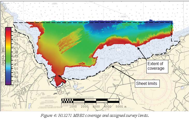
H13271: NOS Hydrographic Survey , 2019-08-08
National Oceanic and Atmospheric Administration, Department of Commerce —
The National Oceanic and Atmospheric Administration (NOAA) has the statutory mandate to collect hydrographic data in support of nautical chart compilation for safe... -
Federal
Hawaiian Hoary Bat Inventory Dataset
Department of the Interior —
This database includes: time, detection type, observation type, location, field notes. -
Federal
Density and vesicularity data for selected lava and tephra samples from the June 2007 Father's Day eruption site, Kīlauea Volcano
Department of the Interior —
An intrusion into Kīlauea’s upper East Rift Zone during June 17–19, 2007, during the 1983–2018 Pu‘u‘ō‘ō eruption, led to widespread ground cracking and a small... -
Federal
USGS Streamgages Linked to the Medium Resolution NHD
Department of the Interior —
The locations of approximately 23,000 current and historical U.S. Geological Survey (USGS) streamgages in the United States and Puerto Rico (with the exception of... -
Federal
Maximum Considered Earthquake Geometric Mean Peak Ground Accelerations for the 2015 NEHRP Recommended Seismic Provisions, 2016 ASCE/SEI 7 Standard, and 2018 International Building Code
Department of the Interior —
The Maximum Considered Earthquake Geometric Mean (MCEG) peak ground acceleration (PGA) values of the 2015 NEHRP Recommended Seismic Provisions, the 2016 ASCE/SEI 7... -
Federal
Papahanaumokuakea Marine National Monument (PMNM), 2006-2016 - Northwestern Hawaiian Islands (NWHI)
National Oceanic and Atmospheric Administration, Department of Commerce —
Boundary of the Papahanaumokuakea Marine National Monument (PMNM), located in the Northwestern Hawaiian Islands (NWHI). Created in 2006, Papahanaumokuakea is the... -
Federal
Species Distribution: Sperm Whale - Hawaii
National Oceanic and Atmospheric Administration, Department of Commerce —
This dataset contains a collection of known point locations of sperm whales identified through direct human observation via shipborne and aerial surveys. This can be... -
Federal
EnviroAtlas - Dairy Cow Operations by County
U.S. Environmental Protection Agency —
This EnviroAtlas dataset summarizes by county the number of farm operations with dairy cows and the number of heads they manage. The data come from the Census of... -
Federal
Waipunalei Beetle Trap Data
Department of the Interior —
These data contain the longhorn beetle (Coleoptera: Cerambycidae) and ambrosia beetle (Coleoptera: Scolytinae) trap data collected at Waipunalei, Hawaii Island. -
Federal
EPA Facility Registry Service (FRS): ER_TRI
U.S. Environmental Protection Agency —
This web feature service contains location and facility identification information from EPA's Facility Registry System (FRS) for the subset of facilities that link to... -
Federal
Pacific Islands Coral Reef Ecosystems Division (CRED) Rapid Ecological Assessment (REA) algae species lists (NCEI Accession 0010352)
National Oceanic and Atmospheric Administration, Department of Commerce —
Quadrats were sampled along consecutively placed transect lines as part of Rapid Ecological Assessments conducted at sites in American Pacific Islands: CRED REA Algal... -
Federal
EF ICIS_AIR
U.S. Environmental Protection Agency —
EF_ICIS_AIR is a subset of facilities from FRS_PROGRAM_FACILITY and associated best-available geospatial coordinates. Facility Registry Service (FRS) data are... -
Federal
Pacific Reef Assessment and Monitoring Program: Stratified Random Surveys (StRS) of Reef Fish, including Benthic Estimate Data at Coral Reef Sites across the Pacific Ocean from 2007 to 2012
National Oceanic and Atmospheric Administration, Department of Commerce —
The stationary point count (nSPC) method was used to conduct reef fish surveys in the Hawaiian and Mariana Archipelagos, American Samoa, and the Pacific Remote Island... -
Federal
Hurricane Storm Surge Inundation: Honolulu, Hawaii
National Oceanic and Atmospheric Administration, Department of Commerce —
Computer model simulation of hurricane storm surge inundation around Honolulu, Hawaii using current sea level at mean higher high water (MHHW) as its baseline water...

Official websites use .gov
A
.gov website belongs to an official government
organization in the United States.
Secure .gov websites use HTTPS
A
lock (
) or https:// means you’ve safely connected to
the .gov website. Share sensitive information only on official,
secure websites.