
-
Federal
JPEG Images of Seismic-Reflection Profiles Collected in the John Day Reservoir in 2000
Department of the Interior —
A two-week field operation was conducted in the John Day Reservoir on the Columbia River to image the floor of the pool, to measure the distribution and thickness of... -
Federal
Utah FORGE: Well 16A(78)-32 Perforation Images and Raw Data
Department of Energy —
This archive contains raw data of visual and acoustic mapping of perforations in Utah FORGE well 16A(78)-32 acquired during the August 2024 circulation program. The... -
Federal
Gazetteer of Planetary Nomenclature: Uranian System: Puck
National Aeronautics and Space Administration —
These images display several of Uranus's moons approved by the International Astronomical Union (IAU). -
Federal
2 meter unenhanced GeoTIFF Sidescan-Sonar Mosaic of Overton Arm - Lake Mead, Nevada (OVERTON_UNGEOG.TIF, geographic)
Department of the Interior —
Lake Mead is a large interstate reservoir located in the Mojave Desert of southeastern Nevada and northwestern Arizona. It was impounded in 1935 by the construction... -
Federal
Point Shapefile of Bottom Photographs Acquired on Cruise SUN03002
Department of the Interior —
Pulley Ridge is a series of drowned barrier islands that extends almost 200 km in 60-100 m water depths. This drowned ridge is located on the Florida Platform in the... -
Federal
Gazetteer of Planetary Nomenclature: Saturnian System: Hyperion
National Aeronautics and Space Administration —
These images display several of Saturn's moons approved by the International Astronomical Union (IAU). -
Federal
Gazetteer of Planetary Nomenclature: Jovian System: Thebe
National Aeronautics and Space Administration —
These images display several of Jupiter's moons approved by the International Astronomical Union (IAU). -
Federal
Geotagged sea-floor images and location of bottom images collected in Long Island Sound, Connecticut and New York, in fall 2017 and spring 2018 by the U.S. Geological Survey, University of Connecticut, and University of New Haven during field activities 2017-056-FA and 2018-018-FA (JPEG images, point shapefile, and CSV file)
Department of the Interior —
Two marine geological surveys were conducted in Long Island Sound, Connecticut and New York, in fall 2017 and spring 2018 by the U.S. Geological Survey (USGS),... -
Federal
Gazetteer of Planetary Nomenclature: Asteroids: Gaspra Regions
National Aeronautics and Space Administration —
These images display asteriods documented and approved by the International Astronomical Union (IAU). -
Federal
WHOLESCALE Catalog of Rock Samples at San Emidio Nevada collected in January 2021
Department of Energy —
This submission contains information on thirty-six rock samples collected from San Emidio, Nevada during January, 2021 for Subtask 2.3 of the WHOLESCALE project. The... -
Federal
Gazetteer of Planetary Nomenclature: Saturnian System: Janus
National Aeronautics and Space Administration —
These images display several of Saturn's moons approved by the International Astronomical Union (IAU). -
Federal
Gazetteer of Planetary Nomenclature: Asteroids: Mathilde
National Aeronautics and Space Administration —
These images display asteriods documented and approved by the International Astronomical Union (IAU). -
Federal
JPEG Images of Seismic-Reflection Profiles Collected in Lake Mead in 1999
Department of the Interior —
Lake Mead is a large interstate reservoir located in the Mojave Desert of southeastern Nevada and northwestern Arizona. It was impounded in 1935 by the construction... -
Federal
Gazetteer of Planetary Nomenclature: Asteroids: Lutetia Regions
National Aeronautics and Space Administration —
These images display asteriods documented and approved by the International Astronomical Union (IAU). -
Federal
Photographic Images of Benthic Coral, Algae, and Invertebrate Species in Marine Habitats and Subhabitats around Offshore Islets in the Main Hawaiian Islands 2007 (NODC Accession 0043046)
National Oceanic and Atmospheric Administration, Department of Commerce —
The marine algae, invertebrate and fish communities were surveyed at ten islet or offshore island sites in the Main Hawaiian Islands in the vicinity of Lanai, (Puu... -
Federal
Earth Resources Observation and Science (EROS) Center's Earth as Art Image Gallery
National Aeronautics and Space Administration —
The Earth Resources Observation and Science (EROS) Center manages this collection of Landsat 7 scenes created for aesthetic purposes rather than scientific... -
Federal
Gazetteer of Planetary Nomenclature: Saturnian System: Iapetus
National Aeronautics and Space Administration —
These images display several of Saturn's moons approved by the International Astronomical Union (IAU). -
Federal
SEG-Y format of Knudsen chirp seismic-reflection profiles collected in Lake Mohave in 2002
Department of the Interior —
Lake Mohave is one of several multi-purpose reservoirs that have been constructed on the Colorado River. The lake was formed upon completion of the Davis Dam in 1953.... -
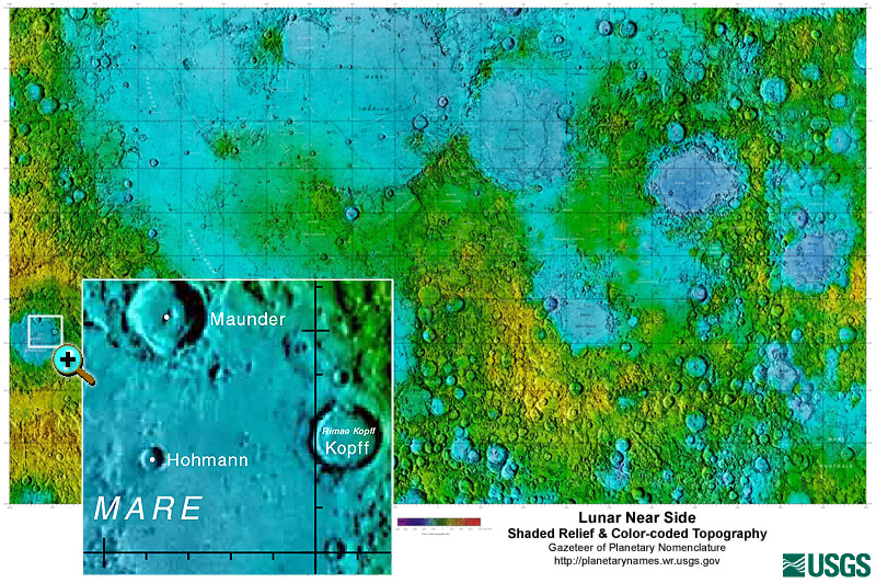
Federal
Gazetteer of Planetary Nomenclature: Moon: 1:10 million-scale Shaded Relief and Color-coded Topography: Near Side
National Aeronautics and Space Administration —
These lunar maps display the four different areas of the moon with color-coded topography in low and high resolution approved by the International Astronomical Union... -
Federal
2 meter unenhanced GeoTIFF Sidescan-Sonar Mosaic East of Virgin Basin - Lake Mead, Nevada (TEMPICE_UNGEOG.TIF , geographic)
Department of the Interior —
Lake Mead is a large interstate reservoir located in the Mojave Desert of southeastern Nevada and northwestern Arizona. It was impounded in 1935 by the construction...

Official websites use .gov
A
.gov website belongs to an official government
organization in the United States.
Secure .gov websites use HTTPS
A
lock (
) or https:// means you’ve safely connected to
the .gov website. Share sensitive information only on official,
secure websites.