
-
Federal
NOAA-20 VIIRS Level-3 Global Mapped 11µm Nighttime Sea Surface Temperature (NSST) - Near Real-time (NRT) Data, version R2024.0
National Aeronautics and Space Administration —
The Ocean Biology DAAC produces near real-time (quicklook) products using the best-available combination of ancillary data from meteorological and ozone data. As... -
Federal
NOAA-20 VIIRS Level-3 Global Binned Triple-window Sea Surface Temperature (SST3) - Near Real-time (NRT) Data, version R2024.0
National Aeronautics and Space Administration —
The Ocean Biology DAAC produces near real-time (quicklook) products using the best-available combination of ancillary data from meteorological and ozone data. As... -
Federal
NOAA-20 VIIRS Level-2 Regional Triple-window Sea Surface Temperature (SST3) Data, version R2024.0
National Aeronautics and Space Administration —
The Visible and Infrared Imager/Radiometer Suite (VIIRS) is a multi-disciplinary instrument that is being flown on the Joint Polar Satellite System (JPSS) series of... -
Federal
NOAA-20 VIIRS Level-3 Global Mapped 11µm Daytime Sea Surface Temperature (SST) Data, version R2024.0
National Aeronautics and Space Administration —
The Visible and Infrared Imager/Radiometer Suite (VIIRS) is a multi-disciplinary instrument that is being flown on the Joint Polar Satellite System (JPSS) series of... -
Federal
MODIS/Terra+Aqua BRDF/Albedo White Sky Albedo Band3 Daily L3 Global 30ArcSec CMG V061
National Aeronautics and Space Administration —
The MCD43D54 Version 6.1 Bidirectional Reflectance Distribution Function and Albedo (BRDF/Albedo) White-Sky Albedo dataset is produced daily using 16 days of Terra... -
Federal
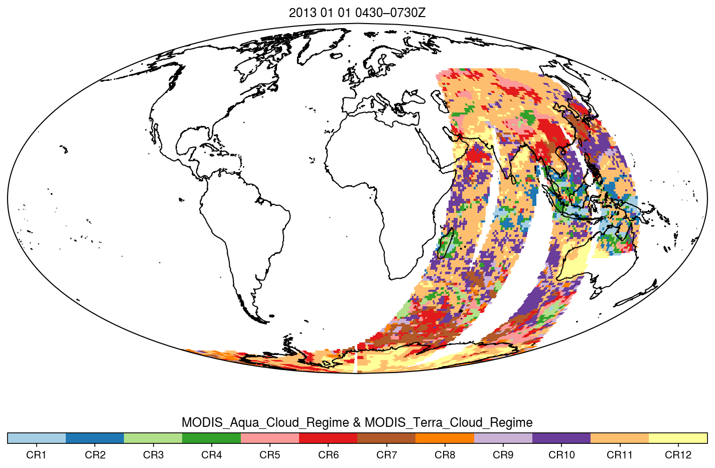
MODIS_CR_Equal_Area_3h
National Aeronautics and Space Administration —
The MODIS Collection 6.1 Equal-Area Three-Hourly Cloud Regime product. This product is a discrete classification of cloud fields at the mesoscale as observed by the... -
Federal
OCO-2 Level 1A collated, parsed, calibration data, Retrospective Processing V11r (OCO2_L1aIn_Pixel) at GES DISC
National Aeronautics and Space Administration —
Version 11r is the current version of the data set. Older versions will no longer be available and are superseded by Version 11r. The Orbiting Carbon Observatory is... -
Federal
Ocean color calibration and validation measurements off the New Jersey and New York coasts
National Aeronautics and Space Administration —
Measurements made off the New Jersey and New York coasts between 2005 and 2009. -
Federal
MODIS/Terra+Aqua BRDF/Albedo Black Sky Albedo Band6 Daily L3 Global 30ArcSec CMG V061
National Aeronautics and Space Administration —
The MCD43D47 Version 6.1 Bidirectional Reflectance Distribution Function and Albedo (BRDF/Albedo) Black-Sky Albedo dataset is produced daily using 16 days of Terra... -
Federal
OCO-3 Level 1A collated, parsed, science or calibration data V11 (OCO3_L1aIn_Sample) at GES DISC
National Aeronautics and Space Administration —
Version 11 is the current version of the data set. Older versions will no longer be available and are superseded by Version 11. The Orbiting Carbon Observatory is the... -
Federal
MODIS Terra Level 3 SST MID-IR Monthly 9km Nighttime V2019.0
National Aeronautics and Space Administration —
Day and night spatially gridded (L3) global NASA skin sea surface temperature (SST) products from the Moderate-resolution Imaging Spectroradiometer (MODIS) onboard... -
Federal
NASA MEASURES Precipitation Ensemble based on TMI TRMM NASA PPS L1C V05 Tbs 1-orbit L2 Swath 5x5km V1 (PRECIP_TMI_TRMM) at GES DISC
National Aeronautics and Space Administration —
The data presented in this level 2 orbital product are rain rate estimates expressed as mm/hour determined from brightness temperatures (Tbs) obtained from the... -
Federal
MODIS/Terra+Aqua BRDF/Albedo Black Sky Albedo Band5 Daily L3 Global 30ArcSec CMG V061
National Aeronautics and Space Administration —
The MCD43D46 Version 6.1 Bidirectional Reflectance Distribution Function and Albedo (BRDF/Albedo) Black-Sky Albedo dataset is produced daily using 16 days of Terra... -
Federal
MLS/Aura Near-Real-Time L2 Sulfur Dioxide (SO2) Mixing Ratio V005 (ML2SO2_NRT) at GES DISC
National Aeronautics and Space Administration —
ML2SO2_NRT is the EOS Aura Microwave Limb Sounder (MLS) Near-Real-Time (NRT) product for sulfur dioxide (SO2). This product contains SO2 profiles derived from the 190... -
Federal
VOYAGER 1 SOLAR WIND PLS 1 HOUR AVERAGES V1.0
National Aeronautics and Space Administration —
Voyager 1 plasma data of the solar wind, 1 hour averages. -
Federal
CERES ERBE-like Gridded Instantaneous TOA Fluxes Terra Crosstrack Edition4
National Aeronautics and Space Administration —
CER_ES9_Terra-Xtrk_Edition4 is the Clouds and the Earth's Radiant Energy System (CERES) Earth Radiation Budget Experiment (ERBE)-like Gridded Instantaneous Top-of-... -
Federal
CMS: LiDAR-derived Estimates of Aboveground Biomass at Four Forested Sites, USA
National Aeronautics and Space Administration —
These data consist of high-resolution maps of aboveground biomass at four forested sites in the US: Garcia River Tract in California, Anne Arundel and Howard Counties... -
Federal
VIIRS/NPP BRDF/Albedo Parameter 1 DNB Daily L3 Global 30 ArcSec CMG V002
National Aeronautics and Space Administration —
The NASA/NOAA Suomi National Polar-orbiting Partnership (Suomi NPP) Visible Infrared Imaging Radiometer Suite (VIIRS) Bidirectional Reflectance Distribution Function... -
Federal
VIIRS/NPP BRDF/Albedo Parameter 1 Band M5 Daily L3 Global 30 ArcSec CMG V001
National Aeronautics and Space Administration —
The VNP43D13 Version 1 data product was decommissioned on July 31, 2025. Users are encouraged to use theFederalSMEX03 ENVISAT ASAR Data, Oklahoma, Version 1
National Aeronautics and Space Administration —
This data set is comprised of browse images acquired over the regional study areas of Alabama, Georgia, and Oklahoma USA as part of the 2003 Soil Moisture Experiment...9,607 datasets found

Official websites use .gov
A
.gov website belongs to an official government
organization in the United States.
Secure .gov websites use HTTPS
A
lock (
) or https:// means you’ve safely connected to
the .gov website. Share sensitive information only on official,
secure websites.