
-
Federal
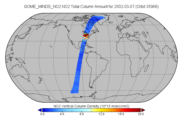
GOME/ERS-2 NO2 Tropospheric, Stratospheric and Total Columns MINDS 1-Orbit L2 Swath 40 km x 320 km V1.1 (GOME_MINDS_NO2) at GES DISC
National Aeronautics and Space Administration —
As part of the NASA's Making Earth System Data Records for Use in Research Environments (MEaSUREs) program, this project entitled “Multi-Decadal Nitrogen Dioxide and... -
Federal
DISCOVER-AQ California Deployment Fresno Ground Site Data
National Aeronautics and Space Administration —
DISCOVERAQ_California_Ground_Fresno_Data contains data collected at the Fresno ground site during the California (San Joaquin Valley) deployment of NASA's DISCOVER-AQ... -
Federal
CERES Clouds and Radiative Swath Aqua FM4 MODIS Edition2B
National Aeronautics and Space Administration —
CER_CRS_Aqua-FM4-MODIS_Edition2B is the Clouds and the Earth's Radiant Energy System (CERES) Clouds and Radiative Swath (CRS) Aqua-Flight Model 4 (FM4) Moderate-... -
Federal
UAVSAR_INSAR_METADATA
National Aeronautics and Space Administration —
UAVSAR Repeat Pass Interferometry Scene Metadata -
Federal
PEM Tropics B DC-8 In-Situ Aerosol Data
National Aeronautics and Space Administration —
PEM-Tropics-B_Aerosol_AircraftInSitu_DC8_Data is the in-situ aerosol data collected onboard the DC-8 aircraft during the Pacific Exploratory Mission (PEM) Tropics B... -
Federal
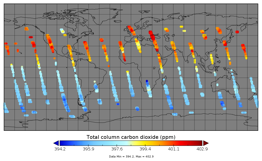
OCO-2 Gridded bias-corrected XCO2 and other select fields aggregated as Level 4 daily files V3 (OCO2GriddedXCO2)
National Aeronautics and Space Administration —
Gridded carbon dioxide mole fraction (XCO2) and other select variables created by applying local kriging (also known as optimal interpolation) to daily aggregates of... -
Federal
Lidar Atmospheric Sensing Experiment (LASE) Data Obtained During the Tropospheric Aerosol Radiative Forcing Observational Experiment (TARFOX)
National Aeronautics and Space Administration —
The Lidar Atmospheric Sensing Experiment (LASE) Tropospheric Aerosol Radiative Forcing Observational Experiment (TARFOX) data set was collected over the Western... -
Federal
Tidal Wetlands Soil Organic Carbon and Estuarine Characteristics, USA, 1972-2015
National Aeronautics and Space Administration —
This dataset provides a synthesis of soil organic carbon (SOC) estimates and a variety of other environmental information from tidal wetlands within estuaries in the... -
Federal
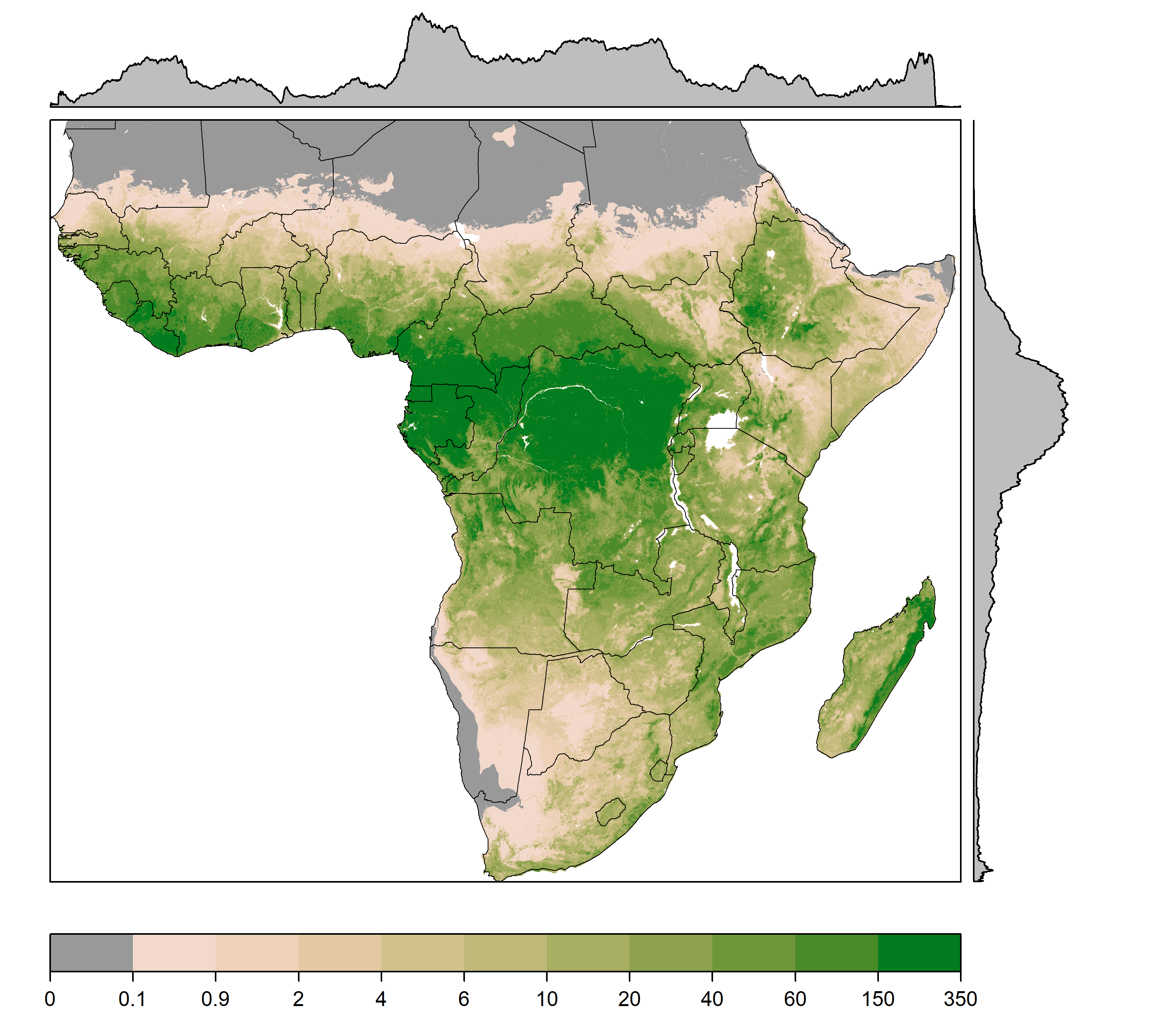
Gridded Estimates of Woody Cover and Biomass across Sub-Saharan Africa, 2000-2004
National Aeronautics and Space Administration —
This dataset provides maps of woody (tree and shrub) cover and biomass across Sub-Saharan Africa at a resolution of 1 km for the period 2000-2004. Canopy cover... -
Federal
GPM ATMS on NOAA-21 Common Calibrated Brightness Temperatures L1C 1.5 hours 17 km V07 (GPM_1CNOAA21ATMS) at GES DISC
National Aeronautics and Space Administration —
Version 07 is the current version of the data set. Older versions will no longer be available and have been superseded by Version 07. 1CATMS contains common... -
Federal
SAFARI 2000 AVHRR-derived Land Surface Temperature Maps, Africa, 1995-2000
National Aeronautics and Space Administration —
Land Surface Temperature (LST) is a key indicator of land surface states, and can provide information on surface-atmosphere heat and mass fluxes, vegetation water... -
Federal
Ground-Based Global Navigation Satellite System (GNSS) High-rate GPS Broadcast Ephemeris Data (sub-hourly files) from NASA CDDIS
National Aeronautics and Space Administration —
This dataset consists of ground-based Global Navigation Satellite System (GNSS) GPS Broadcast Ephemeris Data (sub-hourly files) from the NASA Crustal Dynamics Data... -
Federal
First ISCCP Regional Experiment (FIRE) Atlantic Stratocumulus Transition Experiment (ASTEX) University of Washington C-131A Discrete Data
National Aeronautics and Space Administration —
The First ISCCP Regional Experiments have been designed to improve data products and cloud/radiation parameterizations used in general circulation models (GCMs).... -
Federal
GPM Ground Validation Global Satellite Mapping of Precipitation (GSMaP) IFloodS V1
National Aeronautics and Space Administration —
The GPM Ground Validation Global Satellite Mapping of Precipitation (GSMaP) IFloodS dataset consists of rainfall rate estimates from the GSMaP project. The GSMaP... -
Federal
MODIS/Terra+Aqua Leaf Area Index/FPAR 8-Day L4 Global 500m SIN Grid V061
National Aeronautics and Space Administration —
The MCD15A2H Version 6.1 Moderate Resolution Imaging Spectroradiometer (MODIS) Level 4, Combined Fraction of Photosynthetically Active Radiation (FPAR), and Leaf Area... -
Federal
RLC State and Regional Boundaries for the Former Soviet Union
National Aeronautics and Space Administration —
This data set of state and regional boundaries was derived from the 1:3 million scale administrative boundaries (ESRI, 1998) for the land area of the Former Soviet... -
Federal
NPP Grassland: Consistent Worldwide Site Estimates, 1954-1990, R1
National Aeronautics and Space Administration —
The NPP Database contains documented field measurements of NPP for global terrestrial sites compiled from published literature and other extant data sources. The NPP... -
Federal
ASTER L2 Surface Temperature V003
National Aeronautics and Space Administration —
The Terra Advanced Spaceborne Thermal Emission and Reflection Radiometer (ASTER) Surface Kinetic Temperature (AST_08) is generated using the five Thermal Infrared... -
Federal
ATom: Flight Dynamics and Environmental Parameters of the NASA DC-8 Aircraft
National Aeronautics and Space Administration —
This dataset contains flight dynamics and environmental parameters (often referred to as housekeeping) specific to the DC-8 aircraft as collected from an assortment... -
Federal
SWOT Level 2 Lake Cycle-Averaged Data Product, Version C
National Aeronautics and Space Administration —
Cycle average and aggregation of lake pass data within predefined hydrological basins. Basin for each cycle. Available in Shapefile file format.

Official websites use .gov
A
.gov website belongs to an official government
organization in the United States.
Secure .gov websites use HTTPS
A
lock (
) or https:// means you’ve safely connected to
the .gov website. Share sensitive information only on official,
secure websites.