
-
Federal
2 meter unenhanced GeoTIFF Sidescan-Sonar Mosaic of Virgin Basin - Lake Mead, Nevada (VBASIN_UNGEOG.TIF, geographic)
Department of the Interior —
Lake Mead is a large interstate reservoir located in the Mojave Desert of southeastern Nevada and northwestern Arizona. It was impounded in 1935 by the construction... -
Federal
Enhanced TIFF Sidescan-Sonar Mosaic of Las Vegas Wash - Lake Mead, Nevada: Geographic Coordinates
Department of the Interior —
Lake Mead is a large interstate reservoir located in the Mojave Desert of southeastern Nevada and northwestern Arizona. It was impounded in 1935 by the construction... -
Federal
Enhanced TIFF Sidescan-Sonar Mosaic of Virgin Basin - Lake Mead, Nevada: Geographic Coordinates
Department of the Interior —
Lake Mead is a large interstate reservoir located in the Mojave Desert of southeastern Nevada and northwestern Arizona. It was impounded in 1935 by the construction... -
Federal
EX2107: Windows to the Deep 2021: Southeast U.S. (ROV and Mapping)
National Oceanic and Atmospheric Administration, Department of Commerce —
The Windows to the Deep 2021: Southeast U.S. ROV and Mapping expedition (EX-21-07) was a combined mapping and remotely operated vehicle (ROV) expedition to the Blake... -
Federal
EX2104: 2021 North Atlantic Stepping Stones: New England and Corner Rise Seamounts (ROV and Mapping)
National Oceanic and Atmospheric Administration, Department of Commerce —
The 2021 North Atlantic Stepping Stones: New England and Corner Rise Seamounts expedition (EX-21-04) was a combined mapping and remotely operated vehicle (ROV)... -
Federal
True color aerial imagery collected during uncrewed aircraft systems (UAS) operations: Plum Island Estuary and Parker River NWR (PIEPR), Massachusetts, November 14, 2017 and March 28, 2019
Department of the Interior —
Low-altitude (80 and 100 meters above ground level) digital images were collected by the USGS Woods Hole Coastal and Marine Science Center (WHCMSC) Aerial Imaging and... -
Federal
Structure from motion images collected during marine debris surveys at coral reef sites entangled with derelict fishing nets at Pearl and Hermes Atoll in the Northwestern Hawaiian Islands in 2018 and 2021
National Oceanic and Atmospheric Administration, Department of Commerce —
The photographs described in this dataset were collected using a Structure from Motion (SfM) approach during in-water marine debris swim surveys conducted by... -
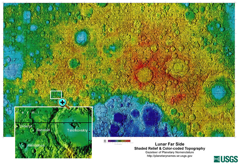
Federal
Gazetteer of Planetary Nomenclature: Moon: 1:10 million-scale Shaded Relief and Color-coded Topography: Far Side
National Aeronautics and Space Administration —
These lunar maps display the four different areas of the moon with color-coded topography in low and high resolution approved by the International Astronomical Union... -
Federal
EX2201: Mapping & ROV Shakedown
National Oceanic and Atmospheric Administration, Department of Commerce —
From February 23 - March 3, 2022 (Pascagoula, MS to Key West, FL), NOAA Ocean Exploration conducted a shakedown of the remotely operated vehicle (ROV), video,... -
Federal
Earth Resources Observation and Science (EROS) Center's Image of the Week Gallery
National Aeronautics and Space Administration —
The Earth Resources Observation and Science (EROS) Center manages the this image of the week gallery. -
Federal
Geotagged lakebed images and their locations collected in the vicinity of Buffalo Reef, Michigan, within Lake Superior during USGS Field Activity 2021-005-FA using the USGS MiniSEABOSS (JPEG images, point shapefile; GCS WGS 84)
Department of the Interior —
In August 2021, the U.S. Geological Survey, in collaboration with the U.S. Army Corps of Engineers, collected high-resolution geophysical data, sediment samples, and... -
Federal
Gazetteer of Planetary Nomenclature: Saturnian System: Mimas
National Aeronautics and Space Administration —
These images display several of Saturn's moons approved by the International Astronomical Union (IAU). -
Federal
JPEG Images of the Floor of the John Day Reservoir - Acquired in 2000
Department of the Interior —
A two-week field operation was conducted in the John Day Reservoir on the Columbia River to image the floor of the pool, to measure the distribution and thickness of... -
Federal
JPEG Images of the Floor of the John Day Reservoir Acquired in 2002
Department of the Interior —
A two-week field operation was conducted in the John Day Reservoir on the Columbia River to image the floor of the pool, to measure the distribution and thickness of... -
Federal
Gazetteer of Planetary Nomenclature: Moon: 1:10 million-scale Shaded Relief and Color-coded Topography: South Pole
National Aeronautics and Space Administration —
These lunar maps display the four different areas of the moon with color-coded topography in low and high resolution approved by the International Astronomical Union... -
Federal
Patent Grant Full Text Data with Embedded TIFF Images (2001 - Present) (Grant Red Book based on WIPO ST.36)
Department of Commerce —
Contains the full text, images/drawings, and complex work units (tables, mathematical expressions, chemical structures, and genetic sequence data) of each patent... -
Federal
Assessing cryptic reef diversity of colonizing marine invertebrates using Autonomous Reef Monitoring Structures (ARMS) deployed at coral reef sites in Timor-Leste from 2012 to 2014
National Oceanic and Atmospheric Administration, Department of Commerce —
The data described here, including photographs, genetic sequences, and specimen information, were collected by the NOAA Coral Reef Ecosystem Program (CREP) from... -
Federal
JPEG Images of seismic-reflection profiles collected in Lake Mohave in 2002
Department of the Interior —
Lake Mohave is one of several multi-purpose reservoirs that have been constructed on the Colorado River. The lake was formed upon completion of the Davis Dam in 1953.... -
Federal
Earth Resources Observation and Science (EROS) Center's Earth as Art Image Gallery 2
National Aeronautics and Space Administration —
The Earth Resources Observation and Science (EROS) Center manages this collection of forty-five new scenes developed for their aesthetic beauty, rather than for... -
Federal
Earth Resources Observation and Science (EROS) Center's Earth as Art Image Gallery 3
National Aeronautics and Space Administration —
The Earth Resources Observation and Science (EROS) Center manages the Earth as Art Three exhibit, which provides fresh and inspiring glimpses of different parts of...

Official websites use .gov
A
.gov website belongs to an official government
organization in the United States.
Secure .gov websites use HTTPS
A
lock (
) or https:// means you’ve safely connected to
the .gov website. Share sensitive information only on official,
secure websites.