
-
Federal
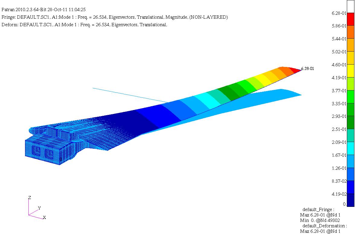
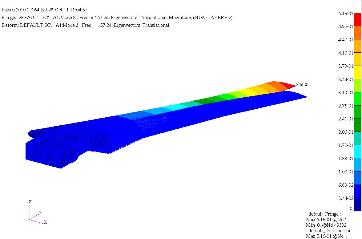
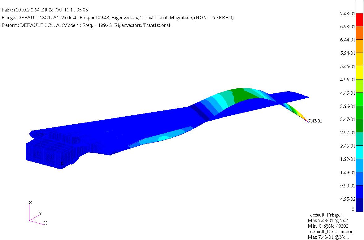
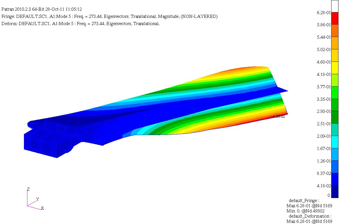
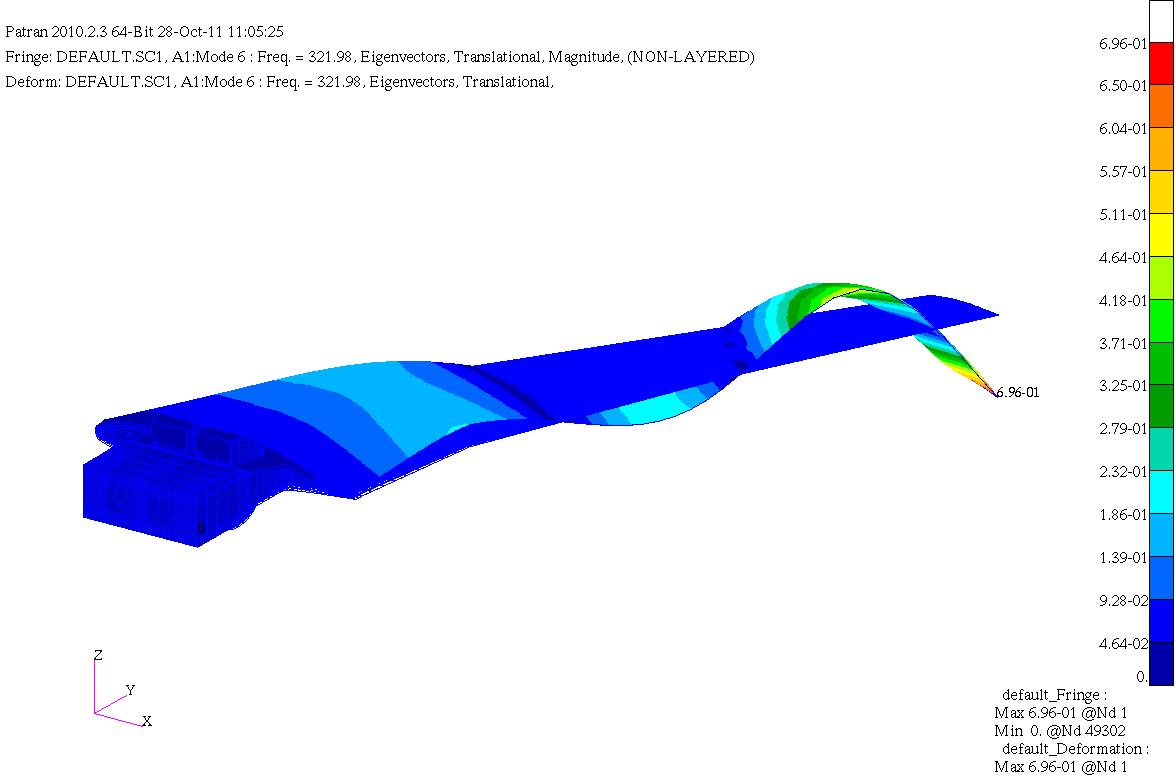
HIRENASD Comparisons of FEM modal frequencies and modeshapes
National Aeronautics and Space Administration —
Below are frequency comparisons of different models with experiment Note Modeshapes aren't very descriptive for higher modes. There is coupling between them so this... -
Federal
Wind Turbine Railroad Setbacks: Ordinances (2022) and Extrapolated Trends, 115 Hub Height 170 Rotor Diameter
Department of Energy —
This dataset represents wind energy setback requirements from railroad based on existing county ordinances as of April 2022. A setback requirement is a minimum... -
Federal
Sentinel-5P TROPOMI Near-Real-Time (NRT) Total Ozone Column 1-Orbit L2 5.5km x 3.5km V2 (S5P_L2__O3_TOT_HiR_NRT) at GES DISC
National Aeronautics and Space Administration —
The Sentinel-5P TROPOMI Near Real Time (NRT) Total Ozone Column 1-Orbit L2 5.5km x 3.5km V2 (S5P_L2__O3_TOT_HiR_NRT) at GES DISC is the near real time version of the... -
Federal
UV-visible absorbance spectra of purified and unpurified m-cresol purple samples in sodium hydroxide and sodium chloride solutions at pH 12
National Institute of Standards and Technology —
M-cresol purple is the most widely used pH indicator dye for seawater pH measurements. Impurities in the indicator are known to absorb strongly at one of the... -
Federal
Daymet: Station-Level Inputs and Cross-Validation for North America, Version 4 R1
National Aeronautics and Space Administration —
This dataset reports the station-level daily weather observation data and the corresponding cross-validation results for three Daymet model parameters: minimum... -
Federal
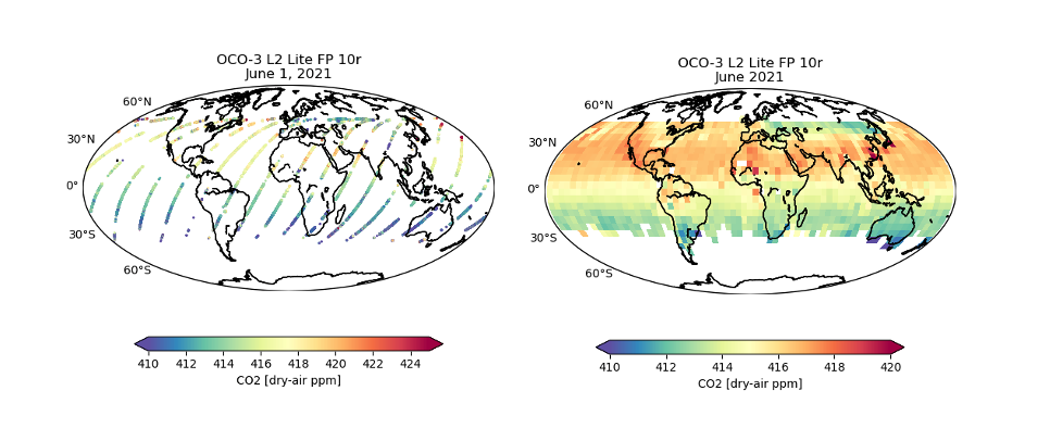
OCO-3 Level 2 bias-corrected XCO2 and other select fields from the full-physics retrieval aggregated as daily files, Retrospective processing V11r (OCO3_L2_Lite_FP) at GES DISC
National Aeronautics and Space Administration —
Version 11r is the current version of the data set. Older versions will no longer be available and are superseded by Version 11r. The Orbiting Carbon Observatory -3... -
Federal
Amazon Forest Structure from Airborne Lidar, ED2 Initial Condition Files, 2016
National Aeronautics and Space Administration —
This dataset provides initial condition files for initializing the Ecosystem Demography Model (ED2). This dataset holds regional forest structure characteristics... -
Federal
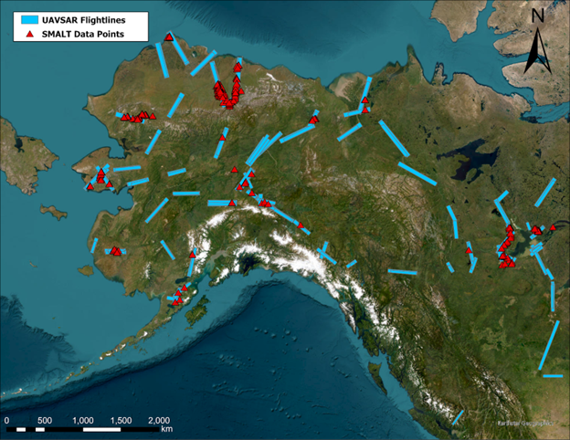
ABoVE: Soil Moisture and Active Layer Thickness in Alaska, USA and Canada, 2005-2022
National Aeronautics and Space Administration —
This dataset provides soil thaw depth and moisture measurements and dielectric properties measured by different research teams at sites in Alaska, U.S., and the... -
Federal
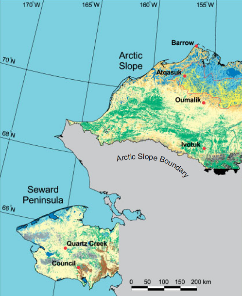
Arctic Vegetation Plots ATLAS Project North Slope and Seward Peninsula, AK, 1998-2000
National Aeronautics and Space Administration —
This data set provides environmental, soil, and vegetation data collected from study sites on the North Slope and Seward Peninsula of Alaska during the Arctic... -
Federal
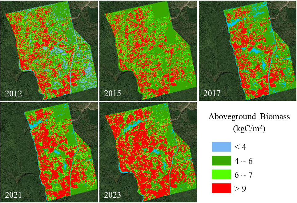
Aboveground Biomass for Howland Forest, Maine, 2012-2023
National Aeronautics and Space Administration —
This dataset holds aboveground biomass (AGB) estimates at 10-m spatial resolution for the Howland Research Forest in central Maine for 2012, 2015, 2017, 2021, and... -
Federal
BOREAS HYD-06 Ground Gravimetric Soil Moisture Data
National Aeronautics and Space Administration —
This data set contains percent soil moisture ground measurements. These data were collected on the ground along the various flight lines flown in the Southern and... -
Federal
ISLSCP II Carbon Dioxide Flux at Harvard Forest and Northern BOREAS Sites
National Aeronautics and Space Administration —
This International Satellite Land Surface Climatology Project (ISLSCP II) data set, ISLSCP II Carbon Dioxide Flux at Harvard Forest and Northern BOREAS Sites,... -
Federal
ISLSCP II IGBP DISCover and SiB Land Cover, 1992-1993
National Aeronautics and Space Administration —
This data set describes the geographic distributions of 17 classes of land cover based on the International Geosphere-Biosphere DISCover land cover legend (Loveland... -
Federal
LBA-ECO ND-01 Forest and Pasture Soil and Grass Analyses, Rondonia, Brazil: 2003-2004
National Aeronautics and Space Administration —
This data set provides soil physical and chemical properties, and grass nutrient measurements of samples collected from 17 pasture sites located within the state of... -
Federal
LBA-ECO CD-10 CO2 and H2O Eddy Flux Data at km 67 Tower Site, Tapajos National Forest
National Aeronautics and Space Administration —
This data set reports eddy flux measurements of CO2 and H2O exchange and associated meteorological measurements at the Para Western (Santarem) - km 67, Primary Forest... -
Federal
ISLSCP II Global Primary Production Data Initiative Gridded NPP Data
National Aeronautics and Space Administration —
Net Primary Production (NPP) is an important component of the carbon cycle and, among the pools and fluxes that make up the cycle, it is one of the steps that are... -
Federal
GPM MHS on METOP-B (GPROF) Climate-based Radiometer Precipitation Profiling L2A 1.5 hours 17 km V07 (GPM_2AGPROFMETOPBMHS_CLIM) at GES DISC
National Aeronautics and Space Administration —
Version 07 is the current version of the data set. Older versions are no longer available and have been superseded by Version 07. The "CLIM" products differ from... -
Federal
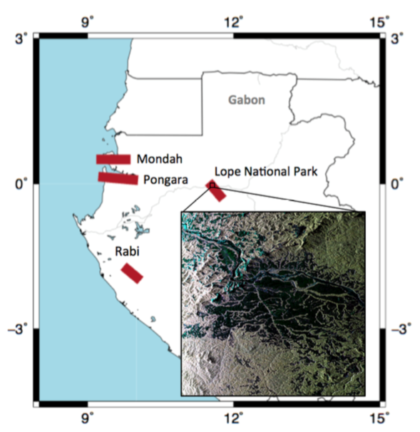
AfriSAR: Canopy Cover and Vertical Profile Metrics Derived from LVIS, Gabon, 2016
National Aeronautics and Space Administration —
This dataset includes footprint-level canopy structure products derived from data collected using NASA's Land, Vegetation, and Ice Sensor (LVIS) during flights over... -
Federal
AfriSAR: Canopy Structure Derived from PolInSAR and Coherence TomoSAR NISAR tools
National Aeronautics and Space Administration —
This dataset contains forest vertical structure and associated uncertainty products derived by applying multi-baseline Polarimetric Interferometric Synthetic Aperture... -
Federal
TOVS GLA 5 DAY GRIDS from NOAA-12 V01 (TOVSA5ND) at GES DISC
National Aeronautics and Space Administration —
This dataset (TOVSA5ND) contains the TIROS Operational Vertical Sounder (TOVS) level 3 geophysical parameters derived using data from NOAA-12 and the physical...

Official websites use .gov
A
.gov website belongs to an official government
organization in the United States.
Secure .gov websites use HTTPS
A
lock (
) or https:// means you’ve safely connected to
the .gov website. Share sensitive information only on official,
secure websites.