
-
H02482: NOS Hydrographic Survey , 1900-12-31
The National Oceanic and Atmospheric Administration (NOAA) has the statutory mandate to collect hydrographic data in support of nautical chart compilation for safe navigation... -
H06402: NOS Hydrographic Survey , 1938-12-31
The National Oceanic and Atmospheric Administration (NOAA) has the statutory mandate to collect hydrographic data in support of nautical chart compilation for safe navigation... -
H05454: NOS Hydrographic Survey , 1933-12-31
The National Oceanic and Atmospheric Administration (NOAA) has the statutory mandate to collect hydrographic data in support of nautical chart compilation for safe navigation... -
Broadband Sound Pressure Levels at 1 Hertz and 1 Hour Resolution Recorded at SanctSound Site MB03_02
This record represents the broadband (BB) sound pressure levels (SPLs) derived from raw passive acoustic data. BB SPLs were calculated by integration of sound pressure spectral... -
H07012: NOS Hydrographic Survey , 1944-12-31
The National Oceanic and Atmospheric Administration (NOAA) has the statutory mandate to collect hydrographic data in support of nautical chart compilation for safe navigation... -
Multibeam collection for E-1-04-SC: Multibeam data collected aboard Maurice Ewing from 08-Aug-04 to 15-Aug-04, None to None
This data set is part of a larger set of data called the Multibeam Bathymetry Database (MBBDB) where other similar data can be found -
B00123: NOS Hydrographic Survey , 1988-04-13
The National Oceanic and Atmospheric Administration (NOAA) has the statutory mandate to collect hydrographic data in support of nautical chart compilation for safe navigation... -
F00436: NOS Hydrographic Survey , Approaches to Brunswick, Georgia, 1997-11-17
The National Oceanic and Atmospheric Administration (NOAA) has the statutory mandate to collect hydrographic data in support of nautical chart compilation for safe navigation... -
B00186: NOS Hydrographic Survey , 1989-07-13
The National Oceanic and Atmospheric Administration (NOAA) has the statutory mandate to collect hydrographic data in support of nautical chart compilation for safe navigation... -
Multibeam collection for KNOX17RR: Multibeam data collected aboard Roger Revelle from 02-May-08 to 31-May-08, Port Everglades, Florida to Woods Hole, Massachusetts
This data set is part of a larger set of data called the Multibeam Bathymetry Database (MBBDB) where other similar data can be found -
H12202: NOS Hydrographic Survey , Approaches to Chesapeake Bay, 2010-10-20
The National Oceanic and Atmospheric Administration (NOAA) has the statutory mandate to collect hydrographic data in support of nautical chart compilation for safe navigation... -
H05545: NOS Hydrographic Survey , 1934-12-31
The National Oceanic and Atmospheric Administration (NOAA) has the statutory mandate to collect hydrographic data in support of nautical chart compilation for safe navigation... -
H00056: NOS Hydrographic Survey , 1840-12-31
The National Oceanic and Atmospheric Administration (NOAA) has the statutory mandate to collect hydrographic data in support of nautical chart compilation for safe navigation... -
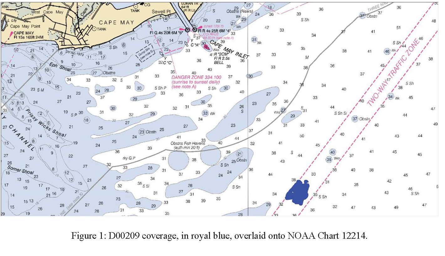
D00209: NOS Hydrographic Survey , 2016-05-03
The National Oceanic and Atmospheric Administration (NOAA) has the statutory mandate to collect hydrographic data in support of nautical chart compilation for safe navigation... -
Multibeam collection for AVON11MV: Multibeam data collected aboard Melville from 15-Aug-99 to 18-Aug-99, San Francisco to Eureka, California
This data set is part of a larger set of data called the Multibeam Bathymetry Database (MBBDB) where other similar data can be found -
H01226B: NOS Hydrographic Survey , 1874-12-31
The National Oceanic and Atmospheric Administration (NOAA) has the statutory mandate to collect hydrographic data in support of nautical chart compilation for safe navigation... -
H06645: NOS Hydrographic Survey , 1940-12-31
The National Oceanic and Atmospheric Administration (NOAA) has the statutory mandate to collect hydrographic data in support of nautical chart compilation for safe navigation... -
H06991: NOS Hydrographic Survey , 1945-12-31
The National Oceanic and Atmospheric Administration (NOAA) has the statutory mandate to collect hydrographic data in support of nautical chart compilation for safe navigation... -
H00133E: NOS Hydrographic Survey , 1841-10-19
The National Oceanic and Atmospheric Administration (NOAA) has the statutory mandate to collect hydrographic data in support of nautical chart compilation for safe navigation... -
NOAA/NCDC Blended Monthly Global 0.25° Sea Surface Wind Stress, 1987-2011
Gridded and blended sea surface windstresses from multiple satellites with direction from NCEP Reanalysis-2; Global ocean coverage with a 0.25-degree resolution; The whole...

Official websites use .gov
A
.gov website belongs to an official government
organization in the United States.
Secure .gov websites use HTTPS
A
lock (
) or https:// means you’ve safely connected to
the .gov website. Share sensitive information only on official,
secure websites.
.jpg)
.jpg)