
-
Brutus Current Profile Time Series
Current profile data from Downward-looking ADCP #00 on FPF Brutus, 2.780000e+01N, 9.067000e+01W, 2007/02/07 00:03 through 2007/09/14 07:28 -
LOXAHATCHEE RIVER AT MILE 9.1 NEAR JUPITER, FL (USGS 265906080093500)
Timeseries data from 'LOXAHATCHEE RIVER AT MILE 9.1 NEAR JUPITER, FL (USGS 265906080093500)' (gov_usgs_nwis_265906080093500) -
RSTSNCA Array, Station USS SCHURZ, Bottom Temperature
Timeseries data from 'RSTSNCA Array, Station USS SCHURZ, Bottom Temperature' (org_secoora_rstsnca_uss_schurz) -
Pacific salmon survey and physical oceanography data collected from the R/V HOKKO MARU in the Bering Sea from 2025-07-26 to 2025-08-03 (NCEI Accession 0312600)
Physical oceanography and fish abundance data collected by CTD, surface trawl, and tagged fish from the research vessel Hokko Maru in the Central Bering Sea. This cruise is U.S.... -
COOPER R AT FILBIN CREEK AT NORTH CHARLESTON, SC (USGS 021720677)
Timeseries data from 'COOPER R AT FILBIN CREEK AT NORTH CHARLESTON, SC (USGS 021720677)' (gov_usgs_nwis_021720677) -
NOAA/NCEI 90-m Bathymetry: American Samoa
A 90-m (3 arc-second) resolution gridded digital elevation model (DEM) for the bathymetry (ocean depth) surrounding American Samoa, including the islands of Tutuila, Ofu,... -
* MARES Marine Mammal Tagging and Tracking - eb03-061-15 - Dives
MARES Pilot Program: Marine Mammal Tagging and Tracking; Satellite data from CTD-fluorometry tags deployed on spotted and bearded seals, Beaufort and Chukchi Seas, August 2015 -... -
Observations of survival, growth, and morphology of snow crabs collected in laboratory experiments for the Effects of Ocean Acidification on Federally Managed Crab Species project in Kodiak, Alaska from 2021-04-23 to 2022-06-03 (NCEI Accession 0307581)
This is data from a laboratory experiment in which snow crab juveniles were held at three different pHs (ambient, pH 7.8, and pH 7.5). Growth, survival, and morphology were... -
Currents, HF Radar, Puerto Rico and the US Virgin Islands, RTV, Near-Real Time, 2012-present, Hourly, 2km, Lon0360
Surface ocean velocities estimated from HF-Radar are representative of the upper 1.0 meters of the ocean. The main objective of near-real time processing is to produce the best... -
Discrete profile measurements of dissolved inorganic carbon (DIC), total alkalinity (TA), temperature, salinity, oxygen, nutrients and Delta Oxygen-18 during the M/V Tiglax Seward Line cruises TXS12 and TXF12 (EXPOCODEs: 33A020120503 and 33A020120913) in the Gulf of Alaska, North Pacific Ocean from 2012-05-03 to 2012-09-18 (NCEI Accession 0210221)
This dataset includes chemical data from discrete samples and accompanying physical data from a profiling CTD collected during the USFWS M/V Tiglax Seward Line cruises TXS12 and... -
Trajectory profile data from glider ru30, including pH, Total Alkalinity, and Aragonite Saturation State, deployed by Rutgers, the State University of New Jersey in the Mid-Atlantic Bight from 2022-09-06 to 2022-09-16 (NCEI Accession 0283870)
This dataset contains the trajectory profile data from glider ru30 from one deployment (2022-09-06 to 2022-09-16) to investigate carbonate chemistry and monitor ocean... -
Partial pressure (or fugacity) of carbon dioxide, salinity and other variables collected from Surface underway observations using Carbon dioxide (CO2) gas analyzer, Shower head chamber equilibrator for autonomous carbon dioxide (CO2) measurement and other instruments from LAURENCE M. GOULD in the North Pacific Ocean, South Atlantic Ocean and others from 2004-12-30 to 2005-11-20 (NCEI Accession 0148772)
This dataset includes Surface underway data collected from LAURENCE M. GOULD in the North Pacific Ocean, South Atlantic Ocean, South Pacific Ocean and Southern Oceans (> 60... -
AVHRR Pathfinder version 5.3 level 3 collated (L3C) global 4km sea surface temperature for 1981-2023
The AVHRR Pathfinder Version 5.3 (PFV53) L3C Sea Surface Temperature dataset is a collection of global, twice-daily (Day and Night) 4km sea surface temperature (SST) data... -
Dissolved inorganic carbon (DIC), total alkalinity, water temperature, salinity, dissolved oxygen, phosphate, silicate, nitrate, nitrite, dissolved organic carbon (DOC), chlorofluorocarbons (CFC-11, CFC-12) and other measurements collected from profile and discrete sample observations during the R/V Pelagia GEOTRACES cruise PE321 (EXPOCODE 64PE20100611) in the North and Tropical Atlantic Ocean from 2010-06-11 to 2010-07-08 (NCEI Accession 0253811)
This dataset includes discrete profile measurements of dissolved inorganic carbon (DIC), total alkalinity, water temperature, salinity, dissolved oxygen, phosphate, silicate,... -
Northern Gulf 1 arc-second NAVD 88 Coastal Digital Elevation Model
NOAA's National Geophysical Data Center (NGDC) is building high-resolution digital elevation models (DEMs) for select U.S. coastal regions in the Gulf of Mexico. These... -
Bathymetry, marine magnetics, water temperature, salinity, and others collected by echo sounder, magnetometer, XCTD, and other instrumentation from the research vessel Hakuho-maru in Southern Marianas from 2023-11-22 to 2023-12-09 (NCEI Accession 0294108)
This dataset contains bathymetry, marine magnetics, water temperature, salinity, and others collected by echo sounder, magnetometer, XCTD, and other instrumentation from the... -
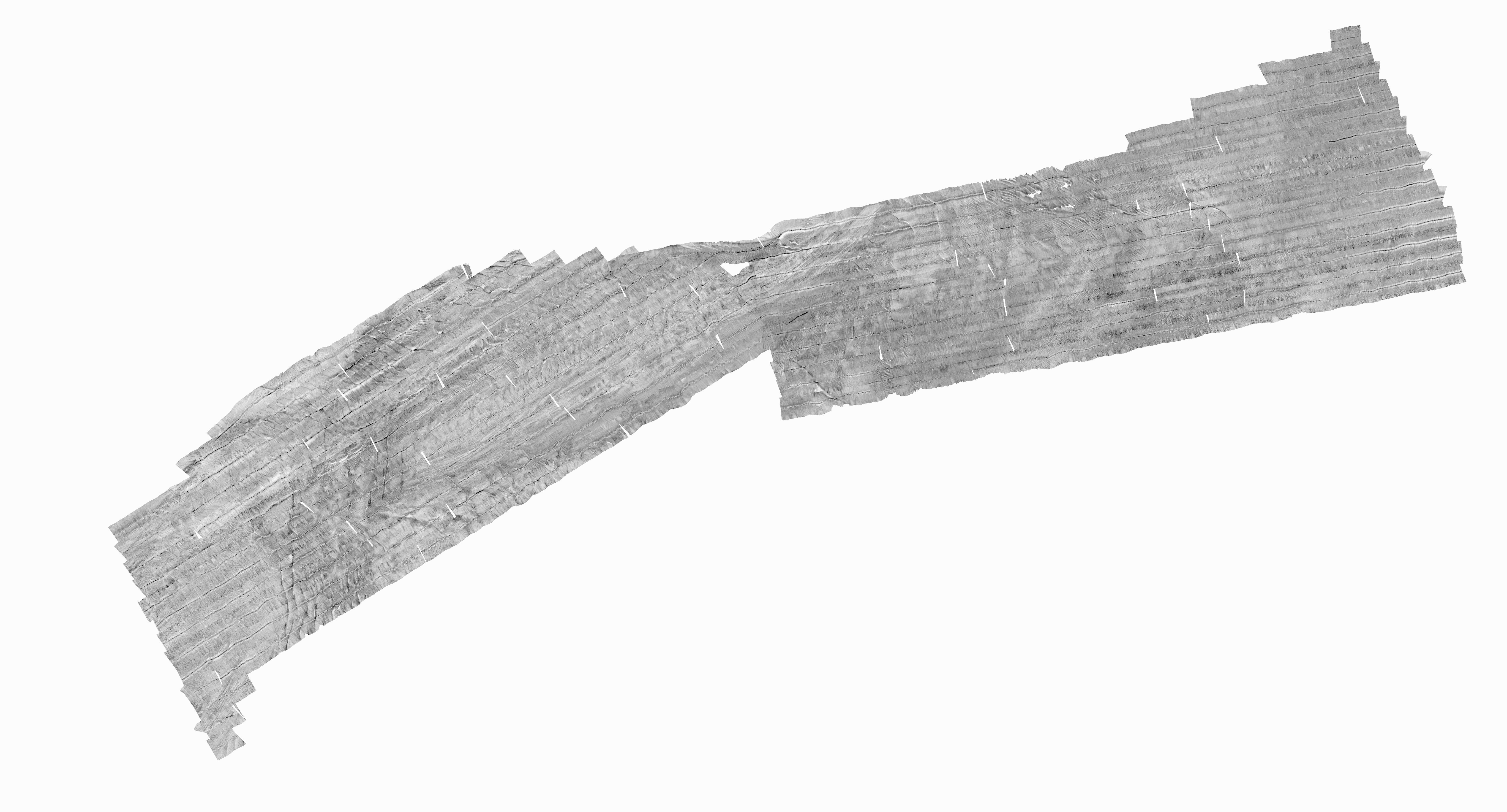
H11078: NOS Hydrographic Survey , Pollock Rip Channel, Massachusetts, 2001-09-13
The National Oceanic and Atmospheric Administration (NOAA) has the statutory mandate to collect hydrographic data in support of nautical chart compilation for safe navigation... -
Physical and meteorological delayed-mode full-resolution data from the Tropical Atmosphere Ocean (TAO) array in the Equatorial Pacific
The Tropical Atmosphere Ocean (TAO) array of moored buoys spans the tropical Pacific. Moorings within the array measure surface meteorological and upper-ocean parameters. This... -
Puget Sound 1/3 arc-second NAVD 88 Coastal Digital Elevation Model
NOAA's National Geophysical Data Center (NGDC) is building high-resolution digital elevation models (DEMs) for select U.S. coastal regions. These integrated bathymetric-...

Official websites use .gov
A
.gov website belongs to an official government
organization in the United States.
Secure .gov websites use HTTPS
A
lock (
) or https:// means you’ve safely connected to
the .gov website. Share sensitive information only on official,
secure websites.