
-
Continuously Updated Digital Elevation Model (CUDEM) - 1/3 Arc-Second Resolution Bathymetric-Topographic Tiles NGDA
NOAA's National Centers for Environmental Information (NCEI) is developing a suite of digital elevation models (DEMs) for the U.S. coast to support a variety of NOAA missions,... -
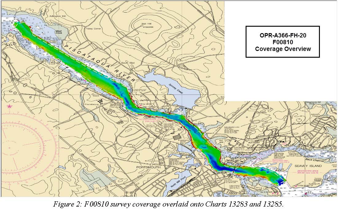
F00810: NOS Hydrographic Survey , 2020-08-05
The National Oceanic and Atmospheric Administration (NOAA) has the statutory mandate to collect hydrographic data in support of nautical chart compilation for safe navigation... -
International Comprehensive Ocean-Atmosphere Data Set (ICOADS)
Surface marine observational records from ships, buoys, and other platform types are processed and binned creating monthly global and regional grids of the observations along... -
Dissolved inorganic carbon (DIC), total alkalinity, pH on total scale, chlorofluorocarbon-11, chlorofluorocarbon-12, temperature, salinity, oxygen, nutrients and other measurements collected from discrete samples and profile observations during the R/V Ryofu Maru III cruise rf201405 (EXPOCODE 49UP20140609), in the North Pacific Ocean from 2014-06-09 to 2014-06-29 (NCEI Accession 0209174)
This dataset includes discrete profile measurements of dissolved inorganic carbon (DIC), total alkalinity, pH on total scale, chlorofluorocarbon-11, chlorofluorocarbon-12,... -
Coastal Mapping Program of Port of Everett, WA, WA2503-CS-N NGDA
These data provide an accurate high-resolution shoreline compiled from imagery of Port of Everett, WA . This vector shoreline data is based on an office interpretation of... -
2025 SCDVA Lidar: Charleston County, SC
BERKELEY, CHARLESTON, ORANGEBURG LIDAR DATA COLLECTION Lidar Data Acquisition and Processing Production Task - Charleston County Contract Number: 6004 RFQ Number: 6004-25C... -
Enhanced Magnetic Model 2015
The Enhanced Magnetic Model (EMM) extends to degree and order 720, resolving magnetic anomalies down to 56 km wavelength. The higher resolution of the EMM results in... -
Coastal Mapping Program of Port of New Haven, CT, CT2502-CS-N NGDA
These data provide an accurate high-resolution shoreline compiled from imagery of Port of New Haven, CT . This vector shoreline data is based on an office interpretation of... -
"NEGOM CTD - n9l11s16.nc - 27.5N, 85.23W - 2000-00-07"
The Northeastern Gulf of Mexico Physical Oceanography Program (NEGOM) is supported by the Minerals Management Service (MMS) of the U.S. Department of the Interior. Through a... -
Walton-Smith CTD, WS15264, WS15264_WS15264sta41, 2015-09-23, 25.7333N 81.575W
Walton-Smith Conductivity, Temperature, Depth (CTD) - WS15264 - WS15264_WS15264sta41 - 2015-09-23 - 25.7333N 81.575W. Hydrographic Measurements in the Gulf of Mexico. flags: 1 =... -
2017 NOAA/MCP Topobathy Lidar DEM: Blue Hill Bay, ME - Riegl Sensor
Fugro was contracted in July 2017 by the State of Maine Department of Marine Resources (SMDMR), Maine Coastal Program (MCP), and the NOAA Office for Coastal Management (OCM) to... -
H07741: NOS Hydrographic Survey , 1949-12-31
The National Oceanic and Atmospheric Administration (NOAA) has the statutory mandate to collect hydrographic data in support of nautical chart compilation for safe navigation... -
H00133A: NOS Hydrographic Survey , 1841-10-19
The National Oceanic and Atmospheric Administration (NOAA) has the statutory mandate to collect hydrographic data in support of nautical chart compilation for safe navigation... -
H06103: NOS Hydrographic Survey , 1936-12-31
The National Oceanic and Atmospheric Administration (NOAA) has the statutory mandate to collect hydrographic data in support of nautical chart compilation for safe navigation... -
H04729: NOS Hydrographic Survey , 1927-12-31
The National Oceanic and Atmospheric Administration (NOAA) has the statutory mandate to collect hydrographic data in support of nautical chart compilation for safe navigation... -
F00036: NOS Hydrographic Survey , 1942-07-12
The National Oceanic and Atmospheric Administration (NOAA) has the statutory mandate to collect hydrographic data in support of nautical chart compilation for safe navigation... -
High-Resolution Seismic Profiles from the US Atlantic Continental Margin Atlantic
Knudsen 320BR CHIRP subbottom data collected simultaneously with multibeam bathymetry and acoustic backscatter. -
Multibeam collection for SKQ201701S: Multibeam data collected aboard Sikuliaq from 19-Jan-17 to 15-Feb-17, Manzanillo, Mexico to San Diego, California
This data set is part of a larger set of data called the Multibeam Bathymetry Database (MBBDB) where other similar data can be found -
Multibeam collection for PD20T401: Multibeam data collected aboard Pressure Drop from 20-Aug-20 to 30-Aug-20, None to Honolulu, Hawaii
This data set is part of a larger set of data called the Multibeam Bathymetry Database (MBBDB) where other similar data can be found

Official websites use .gov
A
.gov website belongs to an official government
organization in the United States.
Secure .gov websites use HTTPS
A
lock (
) or https:// means you’ve safely connected to
the .gov website. Share sensitive information only on official,
secure websites.