-
Bathymetry Mapping of the West Florida Shelf (Central Region), Gulf of Mexico (NODC Accession 0001410)
XYZ ASCII format data generated from the 2001 multibeam sonar survey of the West Florida Shelf, Gulf of Mexico. The data include high-resolution bathymetry and calibrated... -
CRED Simrad em3002d multibeam backscatter data from the banktop and bank edge environments at Tutuila, American Samoa, South Pacific with 1 meter resolution in GeoTIFF format
Multibeam backscatter imagery extracted from gridded bathymetry of Tutuila, American Samoa, South Pacific These data provide coverage between 20 and 5000 meters. The backscatter... -
Backscatter Mapping of the West Florida Shelf (Southern Region), Gulf of Mexico (NODC Accession 0001410)
XYZ ASCII format data generated from the 2001 multibeam sonar survey of the West Florida Shelf, Gulf of Mexico. The data include high-resolution bathymetry and calibrated... -
Backscatter Mapping of the West Florida Shelf (Steamboat Lumps), Gulf of Mexico (NODC Accession 0001410)
XYZ ASCII format data generated from the 2001 multibeam sonar survey of the West Florida Shelf, Gulf of Mexico. The data include high-resolution bathymetry and calibrated... -
CRED Cumulative Map of Percent Scleractinian Coral Cover at Molokai, 2005
This map displays optical validation observation locations and percent coverage of scleractinian coral overlaid on bathymetry. -
The Coral Reef Temperature Anomaly Database (CoRTAD) Version 1 - Global, 4 km, Sea Surface Temperature and Related Thermal Stress Metrics for 1985-2005 (NODC Accession 0044419)
The Coral Reef Temperature Anomaly Database (CoRTAD) is a collection of sea surface temperature (SST) and related thermal stress metrics, developed specifically for coral reef... -
CRED Integrated Benthic Habitat Map for French Frigate Shoals, Northwestern Hawaiian Islands 2007
This is an integrated benthic habitat map system which consists of a number of separate map layers including multibeam bathymetry, acoustic backscatter imagery, hyperlinked... -
CRED Cumulative Map of Percent Scleractinian Coral Cover at Kure Atoll, 2002-2004
This map displays optical validation observation locations and percent coverage of scleractinian coral overlaid on bathymetry. -
Bathymetric Position Index (BPI) Zones 60 m grid derived from gridded bathymetry of the U.S. Territory of Guam.
BPI Zones are derived from a focal mean analysis on bathymetry and slope. The grid is based on gridded (60 m cell size) multibeam bathymetry, collected aboard NOAA Ship... -
Ocean Acidification Product Suite
Scientists within the ACCRETE (Acidification, Climate, and Coral Reef Ecosystems Team) Lab of AOML_s Ocean Chemistry and Ecosystems Division (OCED) have constructed a tool to... -
Rugosity 60 m grid derived from gridded bathymetry of Guam Island, Mariana Islands, USA
Rugosity is derived from gridded (60 m cell size) multibeam bathymetry, collected aboard NOAA Ship Hiialaka'i and R/V AHI, using the Benthic Terrain Modeler with rugosity... -
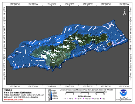
CRED Cumulative Fish Biomass map at Tutuila Island
This map displays fish biomass observation locations overlaid on bathymetry. -
CRED Reson 8101 multibeam backscatter data from the banktop and bank edge environments at Tutuila, American Samoa, South Pacific with 1 meter resolution in GeoTIFF format
Multibeam backscatter imagery extracted from gridded bathymetry of Tutuila, American Samoa, South Pacific These data provide coverage between 20 and 5000 meters. The backscatter... -
CRED Reson 8101 multibeam backscatter data from the lagoon environment at Rose Island, American Samoa, South Pacific with 1 meter resolution in netCDF format
Multibeam backscatter imagery extracted from gridded bathymetry of Rose Island, American Samoa, South Pacific These data provide coverage between 20 and 5000 meters. The... -
Mosaic of 10 m gridded multibeam bathymetry and bathymetry derived from multispectral IKONOS satellite imagery of Maug Island, Commonwealth of the Northern Marianas Islands, USA
Gridded multibeam bathymetry is integrated with bathymetry derived from multpectral IKONOS satellite data. Gridded (5m and 10 m cell size) multibeam bathymetry collected aboard... -
CRED Cumulative Map of Percent Scleractinian Coral Cover at Raita Bank, 2001
This map displays optical validation observation locations and percent coverage of scleractinian coral overlaid on bathymetry. -
Enhancing Management Tools: Molecular Genetic Tracking to Target Microbial Pollution Sources in South Florida Coral Reefs, Year 1 - CRCP project #1114
Both coastal inlets and treated wastewater outfalls are recognized as major pathways for microbial contaminants from Land-Based Sources of Pollution (LBSP) to enter Florida's... -
Mosaic of 10 m gridded multibeam bathymetry and bathymetry derived from multispectral IKONOS satellite imagery of Asuncion Island, Commonwealth of the Northern Marianas Islands, USA
Gridded multibeam bathymetry is integrated with bathymetry derived from multpectral IKONOS satellite data. Gridded (10 m cell size) multibeam bathymetry collected aboard NOAA... -
CRED Simrad em3002d multibeam backscatter data from the banktop and slope environments of Northeast Bank ("Muli" Seamount), American Samoa with 1 meter resolution in netCDF format
Multibeam backscatter imagery extracted from gridded bathymetry of Northeast Bank ("Muli" Seamount), American Samoa. These data provide coverage between 20 and 5000 meters. The... -
Bathymetry Mapping of the West Florida Shelf (Southern Region), Gulf of Mexico (NODC Accession 0001410)
XYZ ASCII format data generated from the 2001 multibeam sonar survey of the West Florida Shelf, Gulf of Mexico. The data include high-resolution bathymetry and calibrated...

Official websites use .gov
A
.gov website belongs to an official government
organization in the United States.
Secure .gov websites use HTTPS
A
lock (
) or https:// means you’ve safely connected to
the .gov website. Share sensitive information only on official,
secure websites.