

TELLUS GRACE Level-3 1.0-degree Glacial Isostatic Adjustment v1.0 datasets produced by JPL
Access & Use Information
Public: This dataset is intended for public access and use.
License:
See this page for license information.
Downloads & Resources
-
Web ResourceBIN
-
Web PageHTML
-
Web PageHTML
-
Web ResourceBIN
-
Web ResourceBIN
-
Web ResourceBIN
-
Web ResourceBIN
-
Web PageHTML
-
Web ResourceBIN
-
Web ResourceBIN
-
JPEG Image FileJPEG
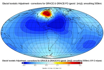
TELLUS_GIA_L3_1-DEG_V1.0.jpg
-
Original MetadataISO
The metadata's original source.
Dates
| Metadata Created Date | April 11, 2025 |
|---|---|
| Metadata Updated Date | April 9, 2026 |
Metadata Source
- Data.json Data.json Metadata
Harvested from NASA Data.json
Additional Metadata
| Resource Type | Dataset |
|---|---|
| Metadata Created Date | April 11, 2025 |
| Metadata Updated Date | April 9, 2026 |
| Publisher | NASA/JPL/GRACE-TELLUS-0001;NASA/JPL/PODAAC |
| Maintainer | |
| Identifier | 10.5067/GRGIA-1DJ10 |
| Data Last Modified | 2026-04-06 |
| Category | Earth Science |
| Public Access Level | public |
| Bureau Code | 026:00 |
| Metadata Context | https://project-open-data.cio.gov/v1.1/schema/catalog.jsonld |
| Schema Version | https://project-open-data.cio.gov/v1.1/schema |
| Catalog Describedby | https://project-open-data.cio.gov/v1.1/schema/catalog.json |
| Harvest Object Id | d28d93f9-8e76-4dee-ba35-33c973821936 |
| Harvest Source Id | 58f92550-7a01-4f00-b1b2-8dc953bd598f |
| Harvest Source Title | NASA Data.json |
| License | https://www.usa.gov/government-works |
| Old Spatial | "CARTESIAN",{"WestBoundingCoordinate":-180.0,"SouthBoundingCoordinate":-90,"EastBoundingCoordinate":180.0,"NorthBoundingCoordinate":90} |
| Program Code | 026:000 |
| Source Datajson Identifier | True |
| Source Hash | 66f96dd03d2b47c3d84de5361e9b516ef87fa9d124eccf4cda12d284b0fce114 |
| Source Schema Version | 1.1 |
| Spatial | |
| Temporal | 2100-12-31/2100-12-31 |
Didn't find what you're looking for? Suggest a dataset here.