


Pacific Islands Passive Acoustic Network (PIPAN) 200 kHz Data
Access & Use Information
Downloads & Resources
-
Passive acoustic Data Map Viewer
Interactive map viewer to allow discovery and access to passive acoustic data
-
Google Cloud Storage
Google Cloud Storage providing public access to passive acoustic data through...
-
PIFSC website
-
NCEI Contact Information
Information for contacts at NCEI.
-
GCMD Keyword Forum Page
Global Change Master Directory (GCMD). 2024. GCMD Keywords, Version 19....
-
GCMD Keyword Forum Page
Global Change Master Directory (GCMD). 2024. GCMD Keywords, Version 19....
-
GCMD Keyword Forum Page
Global Change Master Directory (GCMD). 2024. GCMD Keywords, Version 19....
-
GCMD Keyword Forum Page
Global Change Master Directory (GCMD). 2024. GCMD Keywords, Version 19....
-
GCMD Keyword Forum Page
Global Change Master Directory (GCMD). 2024. GCMD Keywords, Version 19....
Dates
| Metadata Date | July 10, 2025 |
|---|---|
| Metadata Created Date | July 1, 2025 |
| Metadata Updated Date | August 1, 2025 |
| Reference Date(s) | June 26, 2025 (publication) |
| Frequency Of Update | asNeeded |
Metadata Source
- ISO-19139 ISO-19139 Metadata
Harvested from NGDC MGG Passive Acoustic
Graphic Preview
Additional Metadata
| Resource Type | Series |
|---|---|
| Metadata Date | July 10, 2025 |
| Metadata Created Date | July 1, 2025 |
| Metadata Updated Date | August 1, 2025 |
| Reference Date(s) | June 26, 2025 (publication) |
| Responsible Party | DOC/NOAA/NESDIS/NCEI > National Centers for Environmental Information, NESDIS, NOAA, U.S. Department of Commerce (Point of Contact); (Point of Contact) |
| Contact Email | |
| Guid | gov.noaa.ncei.pad:PIPAN_200kHz_Raw_Audio |
| Access Constraints | Distribution liability: NOAA and NCEI make no warranty, expressed or implied, regarding these data, nor does the fact of distribution constitute such a warranty. NOAA and NCEI cannot assume liability for any damages caused by any errors or omissions in these data. If appropriate, NCEI can only certify that the data it distributes are an authentic copy of the records that were accepted for inclusion in the NCEI archives., Use liability: NOAA and NCEI cannot provide any warranty as to the accuracy, reliability, or completeness of furnished data. Users assume responsibility to determine the usability of these data. The user is responsible for the results of any application of this data for other than its intended purpose., Cite as: NOAA NMFS PIFSC. 2025. Pacific Islands Passive Acoustic Network (PIPAN) 200 kHz Data. NOAA National Centers for Environmental Information. https://doi.org/10.25921/69ge-bc95 [access date] |
| Bbox East Long | -156.01483 |
| Bbox North Lat | 28.62745 |
| Bbox South Lat | 0.44345 |
| Bbox West Long | 145.4567 |
| Coupled Resource | |
| Frequency Of Update | asNeeded |
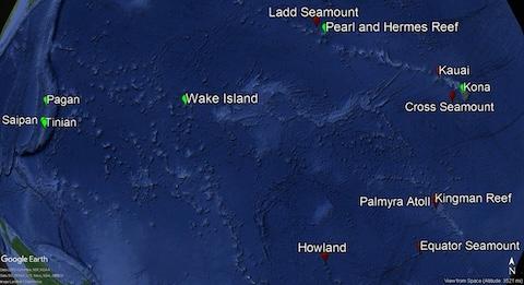
| Graphic Preview Description | Locations of HARPs in the Pacific Islands region to monitor cetacean occurrence and seasonality. Green locations are active as of October 2018 and red locations are currently inactive HARP locations. Credit: NOAA Fisheries |
| Graphic Preview File | https://data.noaa.gov/docucomp/image/3dcc4626-58b7-4c67-ade8-dfb150fe5935 |
| Graphic Preview Type | jpeg, png, etc. |
| Harvest Object Id | 8e1bc300-182d-41d7-a340-a4730ce12bb8 |
| Harvest Source Id | 8812445c-2f10-47c5-80d9-c1bc92ca956d |
| Harvest Source Title | NGDC MGG Passive Acoustic |
| Licence | |
| Lineage | |
| Metadata Language | eng; USA |
| Metadata Type | geospatial |
| Old Spatial | {"type": "Polygon", "coordinates": [[[145.4567, 0.44345], [-156.01483, 0.44345], [-156.01483, 28.62745], [145.4567, 28.62745], [145.4567, 0.44345]]]} |
| Progress | ongoing |
| Spatial Data Service Type | |
| Spatial Reference System | |
| Spatial Harvester | True |
| Temporal Extent Begin | 2005-04-26T00:00:00 |
Didn't find what you're looking for? Suggest a dataset here.