U.S. flag

An official website of the United States government

Official websites use .gov
A .gov website belongs to an official government organization in the United States.

Secure .gov websites use HTTPS
A lock ( ) or https:// means you’ve safely connected to the .gov website. Share sensitive information only on official, secure websites.

Skip to content

Try the next-generation Data Catalog at catalog-beta.data.gov and help shape it with your feedback.

Oceansat-2 Scatterometer Level 2B Ocean Wind Vectors in 12.5km Slice Composites Version 2

Metadata Updated: April 9, 2026

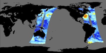
This dataset consists of the version 2 Level 2B science-quality ocean surface wind vector retrievals from the Oceansat-2 scatterometer (OSCAT), which was designed and launched by the Indian Space Research Organization (ISRO) 23 September 2009. This Level 2B dataset is produced by the Jet Propulsion Laboratory (JPL) QuikSCAT Project in cooperation with ISRO. The retrievals are provided on a non-uniform grid within the swath at 12.5 km pixel resolution. This resolution is achieved through a slice composite technique in which high resolution slice measurements from L1B data are composited into a 12.5 km wind vector cell. This newest version contains an improved geophysical model function (GMF), known as QSCAT12, consistent with the Remote Sensing Systems Ku2011 GMF, and an improved rain detection and flagging algorithm; these algorithms are consistent with the latest reprocessed version 3 QuikSCAT L2B dataset. Each L2B file corresponds to a specific orbital revolution (rev) number, which begins at the southernmost point of the ascending orbit. As a Ku-band dual pencil-beam rotating scatterometer, OSCAT design specs bear a strong resemblence of the Ku-band SeaWinds scatterometers on QuikSCAT and Midori-II (ADEOS-II). The primary difference between OSCAT and SeaWinds is the ~4 degree increase in the OSCAT incidence angle, which acts as an offset to the relatively lower altitude of Oceansat-2 to help provide a nearly identical swath width to SeaWinds. In the early phase of cal/val, the JPL QuikSCAT Project identified several problems, most of which have been corrected in this latest L2B version. This dataset release is expected to have an accuracy similar to that of the version 3 L2B QuikSCAT product, with minor caveats, all of which are described by Jaruwatanadilok et al. (2014) and summarized in the User Guide document which is made available in PO.DAAC Drive at https://podaac-tools.jpl.nasa.gov/drive/files/allData/oceansat2/L2B/oscat/jpl/docs/ . Read software is made available in MATLAB, Python, R, and IDL and is accessible in PO.DAAC Drive at https://podaac-tools.jpl.nasa.gov/drive/files/allData/oceansat2/L2B/oscat/jpl/sw/ .

Access & Use Information

Public: This dataset is intended for public access and use. License: See this page for license information.

Downloads & Resources

Dates

Metadata Created Date June 18, 2025
Metadata Updated Date April 9, 2026

Metadata Source

Harvested from NASA Data.json

Additional Metadata

Resource Type Dataset
Metadata Created Date June 18, 2025
Metadata Updated Date April 9, 2026
Publisher NASA/JPL/PODAAC;NASA/JPL/QUIKSCAT
Maintainer
Identifier 10.5067/OSCT2-L2BV2
Data Last Modified 2026-04-06
Category Earth Science
Public Access Level public
Bureau Code 026:00
Metadata Context https://project-open-data.cio.gov/v1.1/schema/catalog.jsonld
Schema Version https://project-open-data.cio.gov/v1.1/schema
Catalog Describedby https://project-open-data.cio.gov/v1.1/schema/catalog.json
Harvest Object Id a65e3610-d00b-40a1-95e6-3aca2d8c11fe
Harvest Source Id 58f92550-7a01-4f00-b1b2-8dc953bd598f
Harvest Source Title NASA Data.json
License https://www.usa.gov/government-works
Old Spatial "CARTESIAN",{"NorthBoundingCoordinate":90.0,"WestBoundingCoordinate":0.0,"EastBoundingCoordinate":180.0,"SouthBoundingCoordinate":-90.0},{"NorthBoundingCoordinate":90.0,"WestBoundingCoordinate":-180.0,"EastBoundingCoordinate":0.0,"SouthBoundingCoordinate":-90.0}
Program Code 026:000
Source Datajson Identifier True
Source Hash 4e3a9e0306af2729354300cf92af13f3a2bf3a34d6ee496d9143ce77b688f7eb
Source Schema Version 1.1
Spatial
Temporal 2010-01-16/2014-02-20

Didn't find what you're looking for? Suggest a dataset here.