


Monitor National Marine Sanctuary Boundary (polygon)
Access & Use Information
License: No license information was provided. If this work was prepared by an officer or employee of the United States government as part of that person's official duties it is considered a U.S. Government Work.
Downloads & Resources
-
NOAA's National Marine Sanctuary BoundariesEsri REST
A publicly available feature layer hosted online (REST Service)
-
mnms_pyHTML
Multiple shapefiles and Google Earth files are available to the public...
-
Full Metadata Record
View the complete metadata record on InPort for more information about this...
-
Monitor National Marine Sanctuary BoundaryHTML
Monitor NMS Boundary Shapefile
-
NOAA's Marine Sanctuary BoundariesEsri REST
National Marine Sanctuary Boundary Online Hosted Feature Layer
-
GCMD Keyword Forum Page
Global Change Master Directory (GCMD). 2025. GCMD Keywords, Version 22....
-
NOAA Data Management Plan (DMP)PDF
NOAA Data Management Plan for this record on InPort.
Dates
| Metadata Date | March 4, 2026 |
|---|---|
| Metadata Created Date | October 31, 2024 |
| Metadata Updated Date | March 10, 2026 |
| Reference Date(s) | July 16, 2025 (revision), 2004-12 (publication) |
| Frequency Of Update |
Metadata Source
- ISO-19139 ISO-19139 Metadata
Harvested from NOS ONMS
Graphic Preview
Additional Metadata
| Resource Type | Dataset |
|---|---|
| Metadata Date | March 4, 2026 |
| Metadata Created Date | October 31, 2024 |
| Metadata Updated Date | March 10, 2026 |
| Reference Date(s) | July 16, 2025 (revision), 2004-12 (publication) |
| Responsible Party | (Point of Contact, Custodian) |
| Contact Email | |
| Guid | gov.noaa.nmfs.inport:40080 |
| Access Constraints | Cite As: Office of National Marine Sanctuaries, [Date of Access]: Monitor National Marine Sanctuary Boundary (polygon) [Data Date Range], https://www.fisheries.noaa.gov/inport/item/40080., Access Constraints: None, Use Constraints: NOT FOR LEGAL USE; NOT FOR NAVIGATION Users must assume responsibility to determine the appropriate and relevant use of these data. This geospatial information is not to be used as LEGAL representations of the sanctuary boundaries. The digital boundaries were created with the most recent and accurate geospatial information available at the time of publication, but their overall extent, area, and/or proportions may change due to natural land changes along shorelines, as well as sanctuary boundary site modifications and expansions, as well as updated source data that is the basis of the boundary. Therefore, the currentness or accuracy of these digital boundaries that are provided to the public cannot be guaranteed., Distribution Liability: Users must assume responsibility to determine the appropriate and relevant use of these data. This geospatial information is not to be used as LEGAL representations of the sanctuary boundaries. The digital boundaries were created with the most recent and accurate geospatial information available at the time of publication, but their overall extent, area, and/or proportions may change due to natural land changes along shorelines, as well as sanctuary boundary site modifications and expansions, as well as updated source data that is the basis of the boundary. Therefore, the currentness or accuracy of these digital boundaries that are provided to the public cannot be guaranteed. |
| Bbox East Long | -75.401255 |
| Bbox North Lat | 35.014901 |
| Bbox South Lat | 34.998235 |
| Bbox West Long | -75.417921 |
| Coupled Resource | |
| Frequency Of Update | |
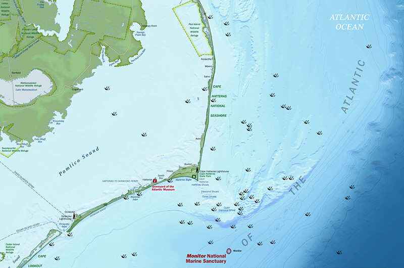
| Graphic Preview Description | Monitor NMS locator map |
| Graphic Preview File | https://monitor.noaa.gov/media/img/20191212-cropped-sanctuary-map-800.jpg |
| Graphic Preview Type | jpg |
| Harvest Object Id | 247a58a2-25e8-4422-9f99-fc5c999810c2 |
| Harvest Source Id | f705727e-6c56-4072-92cc-ce5c5c5b4688 |
| Harvest Source Title | NOS ONMS |
| Licence | NOAA provides no warranty, nor accepts any liability occurring from any incomplete, incorrect, or misleading data, or from any incorrect, incomplete, or misleading use of the data. It is the responsibility of the user to determine whether or not the data is suitable for the intended purpose. |
| Lineage | |
| Metadata Language | eng |
| Metadata Type | geospatial |
| Old Spatial | {"type": "Polygon", "coordinates": [[[-75.417921, 34.998235], [-75.401255, 34.998235], [-75.401255, 35.014901], [-75.417921, 35.014901], [-75.417921, 34.998235]]]} |
| Progress | onGoing |
| Spatial Data Service Type | |
| Spatial Reference System | |
| Spatial Harvester | True |
Didn't find what you're looking for? Suggest a dataset here.