U.S. flag

An official website of the United States government

Official websites use .gov
A .gov website belongs to an official government organization in the United States.

Secure .gov websites use HTTPS
A lock ( ) or https:// means you’ve safely connected to the .gov website. Share sensitive information only on official, secure websites.

Skip to content

Try the next-generation Data Catalog at catalog-beta.data.gov and help shape it with your feedback.

GPS Radio Occultation Boundary Layer Depth Annual L3 V1 (GPSROZPBLA) at GES DISC

Metadata Updated: April 10, 2026

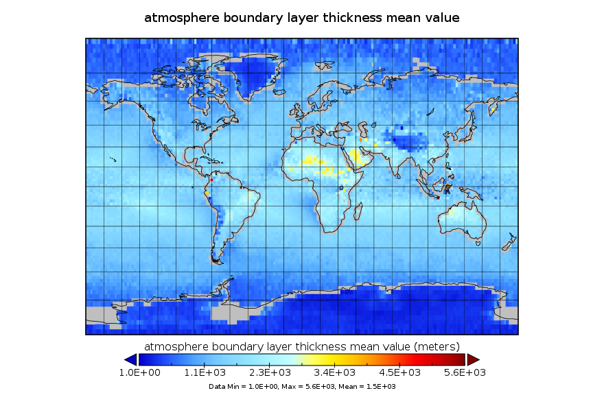
This dataset has been superseded by version 2. It provides an annual average of a global planetary boundary layer (PBL) height climatology derived from the COSMIC/FORMOSAT-3 and TerraSAR-X Global Positioning System (GPS) radio occultation (RO) measurements from June 2006 to December 2015. The COSMIC/FORMOSAT-3 mission consists of a six-satellite constellation launched in 2006. Each satellite carries the IGOR GPS receiver and is equipped with fore and aft looking antenna to track both setting and rising occultations. The constellation provides globally distributed measurements across different local times. The TerraSAR-X (TSX) is a X-band SAR imaging satellite with GPS RO being a secondary measurement. It also carries an IGOR receiver and has been collecting GPS RO measurements since 2011. The instrument tracks the L-band microwave signal broadcast by a GPS satellite in a limb-viewing geometry. The IGOR receivers on COSMIC and TSX are capable of tracking the GPS signals in open loop through the middle to lower troposphere, which is essential for obtaining data with high quality for PBL height estimation, especially at low latitudes. The refractivity profiles from COSMIC and TSX form the basis for this PBL height product. For each occultation, the PBL height is calculated as the height where the vertical gradient of the refractivity (dN/dz) is minimum. This algorithm is designed to locate the height where a large vertical change in refractivity occurs, corresponding to the transition from the free troposphere to the PBL. More details can be found in Ao et al. (2012). Each PBL height is associated with a time (starting time of the occultation) and location (latitude and longitude of the tangent point at the minimum altitude). The PBL height data are then binned into 2 degree x 2 degree latitude/longitude regions and averaged to produce the mean and standard deviation values in the climatology products. The refractivity profile has a vertical resolution of about 200 m and represents an along path horizontal averaging of ~100 km. Thus, occultations with tangent points near the coast may represent averaging over both land and ocean and should be interpreted with care. The refractivity gradient method used here is not the only method that can be used to estimate the PBL height. Other algorithms have been proposed, including looking at "breakpoint" instead of minimum gradient, wavelet covariance transform, and using variables like bending angles or specific humidity instead of refractivity. However, the basic principle is the same. The difference between the different algorithms is small where the PBL is well-defined, with a strong capping inversion.

Access & Use Information

Public: This dataset is intended for public access and use. License: See this page for license information.

Downloads & Resources

Dates

Metadata Created Date April 11, 2025
Metadata Updated Date April 10, 2026

Metadata Source

Harvested from NASA Data.json

Additional Metadata

Resource Type Dataset
Metadata Created Date April 11, 2025
Metadata Updated Date April 10, 2026
Publisher NASA/GSFC/SED/ESD/TISL/GESDISC
Maintainer
Identifier 10.5067/4XKM9DCKEB5K
Data Last Modified 2026-04-06
Category Earth Science
Public Access Level public
Bureau Code 026:00
Metadata Context https://project-open-data.cio.gov/v1.1/schema/catalog.jsonld
Schema Version https://project-open-data.cio.gov/v1.1/schema
Catalog Describedby https://project-open-data.cio.gov/v1.1/schema/catalog.json
Harvest Object Id 1310b6d7-f8fd-4625-9d65-1a2f414b4c21
Harvest Source Id 58f92550-7a01-4f00-b1b2-8dc953bd598f
Harvest Source Title NASA Data.json
License https://www.usa.gov/government-works
Old Spatial "CARTESIAN",{"WestBoundingCoordinate":-180,"NorthBoundingCoordinate":90,"EastBoundingCoordinate":180,"SouthBoundingCoordinate":-90}
Program Code 026:000
Source Datajson Identifier True
Source Hash 897503414f6c6af6c74d9df4d1891f06d81f2293ec43c5781d7b98e56cd9e4c1
Source Schema Version 1.1
Spatial
Temporal 2006-06-01/2015-12-31

Didn't find what you're looking for? Suggest a dataset here.