

ASTER Global Digital Elevation Model V002
Access & Use Information
Public: This dataset is intended for public access and use.
License:
See this page for license information.
Downloads & Resources
-
Web ResourceBIN
ASTGTM.002
-
Web ResourceBIN
-
Web ResourceBIN
-
PDF FilePDF
Summary_GDEM2_validation_report_final.pdf
-
PDF FilePDF
ASTER_L1_Product_Specifications.pdf
-
PDF FilePDF
ASTER_GDEM_Validation_1_Summary_Report.pdf
-
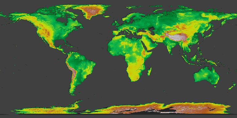
JPEG Image FileJPEG
ASTER_GDEM_Color_Index.jpg
-
Original MetadataISO
The metadata's original source.
Dates
| Metadata Created Date | June 13, 2025 |
|---|---|
| Metadata Updated Date | April 10, 2026 |
Metadata Source
- Data.json Data.json Metadata
Harvested from NASA Data.json
Additional Metadata
| Resource Type | Dataset |
|---|---|
| Metadata Created Date | June 13, 2025 |
| Metadata Updated Date | April 10, 2026 |
| Publisher | LP DAAC;NASA/JPL/ASTER |
| Maintainer | |
| Identifier | 10.5067/ASTER/ASTGTM.002 |
| Data Last Modified | 2026-04-06 |
| Category | Earth Science |
| Public Access Level | public |
| Bureau Code | 026:00 |
| Metadata Context | https://project-open-data.cio.gov/v1.1/schema/catalog.jsonld |
| Schema Version | https://project-open-data.cio.gov/v1.1/schema |
| Catalog Describedby | https://project-open-data.cio.gov/v1.1/schema/catalog.json |
| Harvest Object Id | eddbfeca-ceee-459e-94ba-b9eee7fdd09f |
| Harvest Source Id | 58f92550-7a01-4f00-b1b2-8dc953bd598f |
| Harvest Source Title | NASA Data.json |
| License | https://www.usa.gov/government-works |
| Old Spatial | {"NorthBoundingCoordinate":82,"WestBoundingCoordinate":-180,"EastBoundingCoordinate":180,"SouthBoundingCoordinate":-83},"CARTESIAN" |
| Program Code | 026:000 |
| Source Datajson Identifier | True |
| Source Hash | 85f7b3de304d298702b1f2450f9b80505c409bb14cf9f70c4f6be6c3a3e36429 |
| Source Schema Version | 1.1 |
| Spatial | |
| Temporal | 1999-12-18/2011-02-28 |
Didn't find what you're looking for? Suggest a dataset here.