U.S. flag

An official website of the United States government

Official websites use .gov
A .gov website belongs to an official government organization in the United States.

Secure .gov websites use HTTPS
A lock ( ) or https:// means you’ve safely connected to the .gov website. Share sensitive information only on official, secure websites.

Skip to content

Try the next-generation Data Catalog at catalog-beta.data.gov and help shape it with your feedback.

ASTER Digital Elevation Model V003
Metadata Updated: April 10, 2026

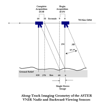
The Terra Advanced Spaceborne Thermal Emission and Reflection Radiometer (ASTER) Digital Elevation Model (AST14DEM) product is generated using bands 3N (nadir-viewing) and 3B (backward-viewing) of an ASTER Level 1A image acquired by the Visible and Near Infrared (VNIR) sensor. The VNIR subsystem includes two independent telescope assemblies that facilitate the generation of stereoscopic data. The band 3 stereo pair is acquired in the spectral range of 0.78 and 0.86 microns with a base-to-height ratio of 0.6 and an intersection angle of 27.7 degrees. There is a time lag of approximately one minute between the acquisition of the nadir and backward images.For a better understanding, refer to the ASTER Along Track Imaging Geometry diagram depicting the along-track imaging geometry of the ASTER VNIR nadir and backward-viewing sensors. The accuracy of the new LP DAAC produced DEMs will meet or exceed accuracy specifications set for the ASTER relative DEMs by the Algorithm Theoretical Basis Document (ATBD). Users likely will find that the DEMs produced by the new LP DAAC system have accuracies approaching those specified in the ATBD for absolute DEMs. Validation testing has shown that DEMs produced by the new system frequently are more accurate than 25 meters root mean square error (RMSE) in xyz dimensions. The ASTER Digital Elevation Model data product is only available through NASA's Earthdata Search. The ASTER Order Instructions provide step-by-step directions for ordering this product. Known Issues * Data acquisition gaps: On November 28, 2024, one of Terra's power-transmitting shunt units failed. As a result, there was insufficient power to maintain functionality of the ASTER instrument. ASTER resumed acquisitions for the VNIR bands on January 18, 2025, and for the TIR bands on April 15, 2025. Users should note the data gap in ASTER acquisitions from November 28, 2024, through January 16, 2025, for VNIR observations, and a gap from November 28, 2024, through April 15, 2025, for TIR acquisitions. Improvements/Changes from Previous Versions * As of January 2021, the LP DAAC has implemented version 3.0 of the Sensor Information Laboratory Corporation ASTER DEM/Ortho (SILCAST) software, which is used to generate the Level 2 on-demand ASTER Orthorectified and Digital Elevation Model (DEM) products (AST14). The updated software provides digital elevation extraction and orthorectification from ASTER L1A input data without needing to enter ground control points or depending on external global DEMs at 30-arc-second resolution (GTOPO30). It utilizes the ephemeris and attitude data derived from both the ASTER instrument and the Terra spacecraft platform. The outputs are geoid height-corrected and waterbodies are automatically detected in this version. Users will notice differences between AST14DEM, AST14DMO, and AST14OTH products ordered before January 2021 (generated with SILCAST V1) and those generated with the updated version of the production software (version 3.0). Differences may include slight elevation changes over different surface types, including waterbodies. Differences have also been observed over cloudy portions of ASTER scenes. Additional information on SILCAST version 3.0 can be found on the SILCAST website. * Starting June 23, 2021, radiometric calibration coefficient Version 5 (RCC V5) will be applied to newly observed ASTER data and archived ASTER data products. Details regarding RCC V5 are described in the following journal article. * Tsuchida, S., Yamamoto, H., Kouyama, T., Obata, K., Sakuma, F., Tachikawa, T., Kamei, A., Arai, K., Czapla-Myers, J.S., Biggar, S.F., and Thome, K.J., 2020, Radiometric Degradation Curves for the ASTER VNIR Processing Using Vicarious and Lunar Calibrations: Remote Sensing, v. 12, no. 3, at https://doi.org/10.3390/rs12030427.

Access & Use Information

Public: This dataset is intended for public access and use. License: See this page for license information.

Downloads & Resources

Dates

Metadata Created Date April 11, 2025
Metadata Updated Date April 10, 2026

Metadata Source

Harvested from NASA Data.json

Additional Metadata

Resource Type Dataset
Metadata Created Date April 11, 2025
Metadata Updated Date April 10, 2026
Publisher LP DAAC;JP/METI/AIST/JSS/GDS
Maintainer
Identifier 10.5067/ASTER/AST14DEM.003
Data Last Modified 2026-04-06
Category Earth Science
Public Access Level public
Bureau Code 026:00
Metadata Context https://project-open-data.cio.gov/v1.1/schema/catalog.jsonld
Schema Version https://project-open-data.cio.gov/v1.1/schema
Catalog Describedby https://project-open-data.cio.gov/v1.1/schema/catalog.json
Harvest Object Id 54d0b28f-1b0d-4036-98e9-7efd68184d30
Harvest Source Id 58f92550-7a01-4f00-b1b2-8dc953bd598f
Harvest Source Title NASA Data.json
License https://www.usa.gov/government-works
Old Spatial {"NorthBoundingCoordinate":83,"WestBoundingCoordinate":-180,"EastBoundingCoordinate":180,"SouthBoundingCoordinate":-83},"CARTESIAN"
Program Code 026:000
Source Datajson Identifier True
Source Hash cbfa97eea470480c1d9671f90c3a4ae50138a56f5044f05a2b001f91fa91b746
Source Schema Version 1.1
Spatial
Temporal 2000-03-06/2026-03-30

Didn't find what you're looking for? Suggest a dataset here.