
-
Federal
NLDAS Primary Forcing Data L4 Monthly 0.125 x 0.125 degree V2.0 (NLDAS_FORA0125_M) at GES DISC
National Aeronautics and Space Administration —
This data product contains the monthly primary forcing data "File A" for Phase 2 of the North American Land Data Assimilation System (NLDAS-2). The data are in 1/8th... -
Federal
GPM IMERG Final Precipitation L3 1 day 0.1 degree x 0.1 degree V07 (GPM_3IMERGDF) at GES DISC
National Aeronautics and Space Administration —
Version 07 is the current version of the data set. Older versions will no longer be available and have been superseded by Version 07. The Integrated Multi-satellitE... -
Federal
MERRA-2 tavg1_2d_aer_Nx: 2d,1-Hourly,Time-averaged,Single-Level,Assimilation,Aerosol Diagnostics 0.625 x 0.5 degree V5.12.4 (M2T1NXAER) at GES DISC
National Aeronautics and Space Administration —
M2T1NXAER (or tavg1_2d_aer_Nx) is an hourly time-averaged 2-dimensional data collection in Modern-Era Retrospective analysis for Research and Applications version 2... -
Federal
TROPESS CrIS-SNPP L2 for Tokyo Megacity, Standard Product V1 (TRPSDL2ALLCRSMGTOK) at GES DISC
National Aeronautics and Space Administration —
The TROPESS CrIS-SNPP L2 for Tokyo Megacity, Standard Product contains the vertical distribution of seven retrieved atmospheric gases (CH4, CO, H2O, HDO, NH3, O3 and... -
Federal
TROPESS CrIS-SNPP L2 for Beijing Megacity, Standard Product V1 (TRPSDL2ALLCRSMGBEI) at GES DISC
National Aeronautics and Space Administration —
The TROPESS CrIS-SNPP L2 for Beijing Megacity, Standard Product contains the vertical distribution of seven retrieved atmospheric gases (CH4, CO, H2O, HDO, NH3, O3... -
Federal
OCO-3 Level 2 spatially ordered geolocated retrievals screened using the IMAP-DOAS Preprocessor (IDP), Retrospective Processing V11r (OCO3_L2_IMAPDOAS) at GES DISC
National Aeronautics and Space Administration —
Version 11r is the current version of the data set. Older versions will no longer be available and are superseded by Version 11r. The Orbiting Carbon Observatory -3... -
Federal
TROPESS CrIS-SNPP L2 for Delhi Megacity, Summary Product V1 (TRPSYL2ALLCRSMGDEL) at GES DISC
National Aeronautics and Space Administration —
The TROPESS CrIS-SNPP L2 for Delhi Megacity, Summary Product contains the vertical distribution of six retrieved atmospheric gases (CH4, CO, HDO, NH3, O3 and PAN),... -
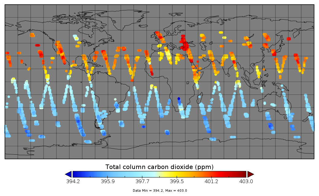
Federal
OCO-3 Level 2 CO2 prior based on CO2 monthly flask record, global meteorology, and age of air, Retrospective Processing V10r (OCO3_L2_CO2Prior) at GES DISC
National Aeronautics and Space Administration —
Version 10r is the current version of the data set. Older versions will no longer be available and are superseded by Version 10r. The Orbiting Carbon Observatory -3... -
Federal
TROPESS CrIS-SNPP L2 for Mexico City Megacity, Standard Product V1 (TRPSDL2ALLCRSMGMEX) at GES DISC
National Aeronautics and Space Administration —
The TROPESS CrIS-SNPP L2 for Mexico City Megacity, Standard Product contains the vertical distribution of seven retrieved atmospheric gases (CH4, CO, H2O, HDO, NH3,... -
Federal
IMERG and LHASA Global Landslide Exposure Maps 1.0
National Aeronautics and Space Administration —
The Landslide Hazard Assessment for Situational Awareness (LHASA) model identifies locations with high potential for landslide occurrence at a daily temporal... -
Federal
GLDAS Noah Land Surface Model L4 3 hourly 0.25 x 0.25 degree V2.0 (GLDAS_NOAH025_3H) at GES DISC
National Aeronautics and Space Administration —
NASA Global Land Data Assimilation System Version 2 (GLDAS-2) has three components: GLDAS-2.0, GLDAS-2.1, and GLDAS-2.2. GLDAS-2.0 is forced entirely with the... -
Federal
Multi-Instrument Fused bias-corrected XCO2 and other select fields aggregated as Level 4 daily files V3 (MultiInstrumentFusedXCO2)
National Aeronautics and Space Administration —
Gridded carbon dioxide mole fraction (XCO2) and other select variables created by applying local kriging (also known as optimal interpolation) to daily aggregates of... -
Federal
Aqua/AIRS L2 Support Retrieval (AIRS+AMSU) V7.0 at GES DISC
National Aeronautics and Space Administration —
The Atmospheric Infrared Sounder (AIRS) is a grating spectrometer (R = 1200) aboard the second Earth Observing System (EOS) polar-orbiting platform, EOS Aqua. In... -
Federal
Global Inventory of Methane Emissions from Fuel Exploitation V1 (GFEI_CH4)
National Aeronautics and Space Administration —
This is a global inventory of methane emissions from fuel exploitation (GFEI) created for the NASA Carbon Monitoring System (CMS). The emission sources represented in... -
Federal
GPM AMSU-B on NOAA 16 Common Calibrated Brightness Temperatures L1C 1.5 hours 16 km V07 (GPM_1CNOAA16AMSUB) at GES DISC
National Aeronautics and Space Administration —
Version 07 is the current version of the data set. Older versions will no longer be available and have been superseded by Version 07. All 1C products have a common... -
Federal
TROPESS CrIS-SNPP L2 for Delhi Megacity, Standard Product V1 (TRPSDL2ALLCRSMGDEL) at GES DISC
National Aeronautics and Space Administration —
The TROPESS CrIS-SNPP L2 for Delhi Megacity, Standard Product contains the vertical distribution of seven retrieved atmospheric gases (CH4, CO, H2O, HDO, NH3, O3 and... -
Federal
GPM IMERG Early Precipitation L3 Half Hourly 0.1 degree x 0.1 degree V07 (GPM_3IMERGHHE) at GES DISC
National Aeronautics and Space Administration —
Version 07B is the current version of the IMERG data sets. Older versions will no longer be available and have been superseded by Version 07. The Integrated Multi-... -
Federal
GLDAS Noah Land Surface Model L4 monthly 0.25 x 0.25 degree V2.1 (GLDAS_NOAH025_M) at GES DISC
National Aeronautics and Space Administration —
NASA Global Land Data Assimilation System Version 2 (GLDAS-2) has three components: GLDAS-2.0, GLDAS-2.1, and GLDAS-2.2. GLDAS-2.0 is forced entirely with the... -
Federal
OCO-2 Level 2 bias-corrected XCO2 and other select fields from the full-physics retrieval aggregated as daily files, Retrospective processing V11.1r (OCO2_L2_Lite_FP) at GES DISC
National Aeronautics and Space Administration —
Version 11r is the current version of the data set. Older versions will no longer be available and are superseded by Version 11r. The OCO-2 Lite files contain bias-... -
Federal
CAR LEADEX Arctic Sea Ice and Tundra Radiation Measurements L1 V1 (CAR_LEADEX_L1C) at GES DISC
National Aeronautics and Space Administration —
CAR LEADEX mission measured bidirectional reflectance functions for four common arctic surfaces: snow covered sea ice, melt season sea ice, snow covered tundra, and...

Official websites use .gov
A
.gov website belongs to an official government
organization in the United States.
Secure .gov websites use HTTPS
A
lock (
) or https:// means you’ve safely connected to
the .gov website. Share sensitive information only on official,
secure websites.