
-
Federal
National Assessment of Hurricane-Induced Coastal Erosion Hazards: South Carolina through New Hampshire Update
Department of the Interior —
This data set contains information on the probabilities of hurricane-induced erosion (collision, inundation and overwash) for each 1-km section of the United States... -
Federal
EnviroAtlas Impervious Proximity Gradient Web Service
U.S. Environmental Protection Agency —
This EnviroAtlas web service supports research and online mapping activities related to EnviroAtlas (https://www.epa.gov/enviroatlas). In any given 1-square meter... -
Federal
NCVAS State Summary Maine FY2023
Department of Veterans Affairs —
NCVAS State Summary Maine FY2023 -
Federal
Long-period transition period, TL, for the conterminous United States, Alaska, Hawaii, Puerto Rico and United States Virgin Islands, 2009 NEHRP.
Department of the Interior —
For designing buildings and other structures to safely resist earthquakes, the 2009 NEHRP Recommended Seismic Provisions and the 2010 ASCE/SEI 7 Standard contain maps... -
Federal
LOBO 2 Buoy Mid Damariscotta River
National Oceanic and Atmospheric Administration, Department of Commerce —
Maine EPSCoR SEANET Buoy Network is developing oceanographic models of factors which control the productivity of Maine's coastal waters in three bioregions (southern,... -
State
Northeastern States County Boundary Set
State of Connecticut —
Northeastern United States County Boundary data are intended for geographic display of state and county boundaries at statewide and regional levels. Use it to map and... -
Federal
Geologic formations and mine locations for potential CO2 mineralization
Department of the Interior —
This geodatabase contains geologic unit boundaries and asbestos site locations shown in "Carbon dioxide mineralization feasibility in the United States" (Blondes and... -
Federal
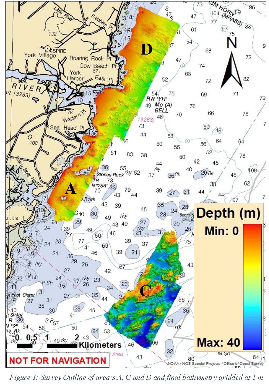
W00492: NOS Hydrographic Survey , External Source Data 2019, 2019-07-03
National Oceanic and Atmospheric Administration, Department of Commerce —
The National Oceanic and Atmospheric Administration (NOAA) has the statutory mandate to collect hydrographic data in support of nautical chart compilation for safe... -
Federal
Modified Mercalli Intensity based on peak ground acceleration, with 1-percent probability of exceedance in 1 year
Department of the Interior —
A one-year seismic hazard forecast for the Central and Eastern United States, based on induced and natural earthquakes, has been produced by the U.S. Geological... -
Federal
H04304: NOS Hydrographic Survey
National Oceanic and Atmospheric Administration, Department of Commerce —
The National Oceanic and Atmospheric Administration (NOAA) has the statutory mandate to collect hydrographic data in support of nautical chart compilation for safe... -
Federal
N01 Met - Meteorology
National Oceanic and Atmospheric Administration, Department of Commerce —
Ocean observation data from the Northeastern Regional Association of Coastal & Ocean Observing Systems (NERACOOS). The NERACOOS region includes the northeast... -
Federal
Wave Energy Prize - 1/50th Testing - Float Inc. BergerABAM Rho-Cee Hybrid WEC
Department of Energy —
This submission of data includes all the 1/50th scale testing data completed on the Wave Energy Prize for Float Inc. During the testing of its 1/50th-scale device,... -
Federal
TIGER/Line Shapefile, 2024, State, Maine, ME, 2020 Census Public Use Microdata Area (PUMA)
U.S. Census Bureau, Department of Commerce —
The TIGER/Line shapefiles and related database files (.dbf) are an extract of selected geographic and cartographic information from the U.S. Census Bureau's Master... -
Federal
LOBO 1 Buoy Upper Damariscotta River
National Oceanic and Atmospheric Administration, Department of Commerce —
Maine EPSCoR SEANET Buoy Network is developing oceanographic models of factors which control the productivity of Maine's coastal waters in three bioregions (southern,... -
Federal
U.S. EPA Metadata Editor (EME)
U.S. Environmental Protection Agency —
The EPA Metadata Editor (EME) allows users to create geospatial metadata that meets EPA's requirements. The tool has been developed as a desktop application that... -
Federal
Hazard curve data for annual rate of exceedance versus 1.0-second spectral response acceleration
Department of the Interior —
A one-year seismic hazard forecast for the Central and Eastern United States, based on induced and natural earthquakes, has been produced by the U.S. Geological... -
Federal
USEPA Environmental Quality Index (EQI) - Air, Water, Land, Built, and Sociodemographic Domains Non-Transformed Variables Dataset as Input for the 2006-2010 USEPA EQI, by County for the United States
U.S. Environmental Protection Agency —
The US Environmental Protection Agency's (EPA) Center for Public Health and Environmental Assessment (CPHEA) in the Public Health and Environmental Systems Division... -
Federal
EnviroAtlas - Watershed Index Online Hydrologically Connected Zone Mask for the Conterminous United States
U.S. Environmental Protection Agency —
The Hydrologically Connected Zone (HCZ) Mask was determined using grid analysis to combine surface water features in the United States from three datasets: First, the... -
State
Northeastern States State Boundary Set
State of Connecticut —
Northeastern United States State Boundary data are intended for geographic display of state boundaries at statewide and regional levels. Use it to map and label...

Official websites use .gov
A
.gov website belongs to an official government
organization in the United States.
Secure .gov websites use HTTPS
A
lock (
) or https:// means you’ve safely connected to
the .gov website. Share sensitive information only on official,
secure websites.