
-
Federal
Matrix inhibition PCR and Microtox® 81.9% screening assay analytical results for samples collected for the Sediment-Bound Contaminant Resiliency and Response Strategy pilot study, northeastern United States, 2015
Department of the Interior —
Coastal communities are uniquely vulnerable to sea-level rise (SLR) and severe storms such as hurricanes. These events enhance the dispersion and concentration of... -
Federal
The StreamCat Dataset: Accumulated Attributes for NHDPlusV2 (Version 2.1) Catchments for the Conterminous United States: Aquifers
U.S. Environmental Protection Agency —
This dataset represents percent area consisting of carbonate-rock aquifers, igneous and metamorphic-rock, sandstone, sandstone and carbonate-rock, semiconsolidated... -
Federal
2020 Cartographic Boundary File (KML), Current State Legislative District-Upper Chamber for Maine, 1:500,000
U.S. Census Bureau, Department of Commerce —
The 2020 cartographic boundary KMLs are simplified representations of selected geographic areas from the U.S. Census Bureau's Master Address File / Topologically... -
Federal
M01 SUNA - Nitrate Observations Corrected
National Oceanic and Atmospheric Administration, Department of Commerce —
Various nitrate sensors including the SUNA V1, SUNA V2 and ISUS (Sea-Bird Scientific) were deployed on NERACOOS Buoy M (Latitude: 43ð 29.44'N and Longitude: 67ð... -
Federal
Inundation predictions for vernal pools of the northeastern United States at various seasonal time points under various weather and climate scenarios
Department of the Interior —
This data release includes data-processing scripts, data products, and associated metadata for a study to model the hydrology of several hundred vernal pools (i.e.,... -
Federal
An Unvegetated to Vegetated Ratio (UVVR) for coastal wetlands of the Atlantic Coast - 2015
Department of the Interior —
Prior research has shown that sediment budgets, and therefore stability, of microtidal marsh complexes scale with areal unvegetated to vegetated marsh ratios (UVVR)... -
Federal
H02137: NOS Hydrographic Survey , 1892-12-31
National Oceanic and Atmospheric Administration, Department of Commerce —
The National Oceanic and Atmospheric Administration (NOAA) has the statutory mandate to collect hydrographic data in support of nautical chart compilation for safe... -
Federal
Catalog of natural earthquakes without duplicates for the central and eastern U.S.
Department of the Interior —
A methodology has been developed at the U.S. Geological Survey (USGS) for making earthquake catalogs for seismic hazard analysis. A new catalog is assembled from... -
Federal
TEMPESTS ME305 CTD - CINAR
National Oceanic and Atmospheric Administration, Department of Commerce —
CINAR Storm ME305 CTD Observations -
Federal
NOAA Digital Oblique Imagery Collection for the Coasts of Main/New Hampshire, Massachusetts/Rhode Island/Connecticut, and Hudson River/Long Island /NY/NJ
National Oceanic and Atmospheric Administration, Department of Commerce —
Project: NOAA Digital Orthophotography and Ancillary Oblique Imagery Collection for the Coasts of Main/New Hampshire, Massachusetts/Rhode Island/Connecticut, and... -
Federal
EnviroAtlas - 2019 Floodplain Land Cover Proportions for the Conterminous United States
U.S. Environmental Protection Agency —
This EnviroAtlas dataset represents the percentage of land area in estimated floodplains that is classified as natural, forest, shrubland, wetland, developed, low... -
Federal
Forest Health Protection Tree Species Metrics Basal Area (Image Service)
Department of Agriculture —
Basal Area (BA). 30 meter pixel resolution. Data represents forest conditions circa 2002.These data are a product of a multi-year effort by the FHTET (Forest Health... -
Federal
Shoreline Data Rescue Project of Brunswick, Maine, CS272B2 NGDA
National Oceanic and Atmospheric Administration, Department of Commerce —
These data were automated to provide an accurate high-resolution historical shoreline of Brunswick, Maine suitable as a geographic information system (GIS) data... -
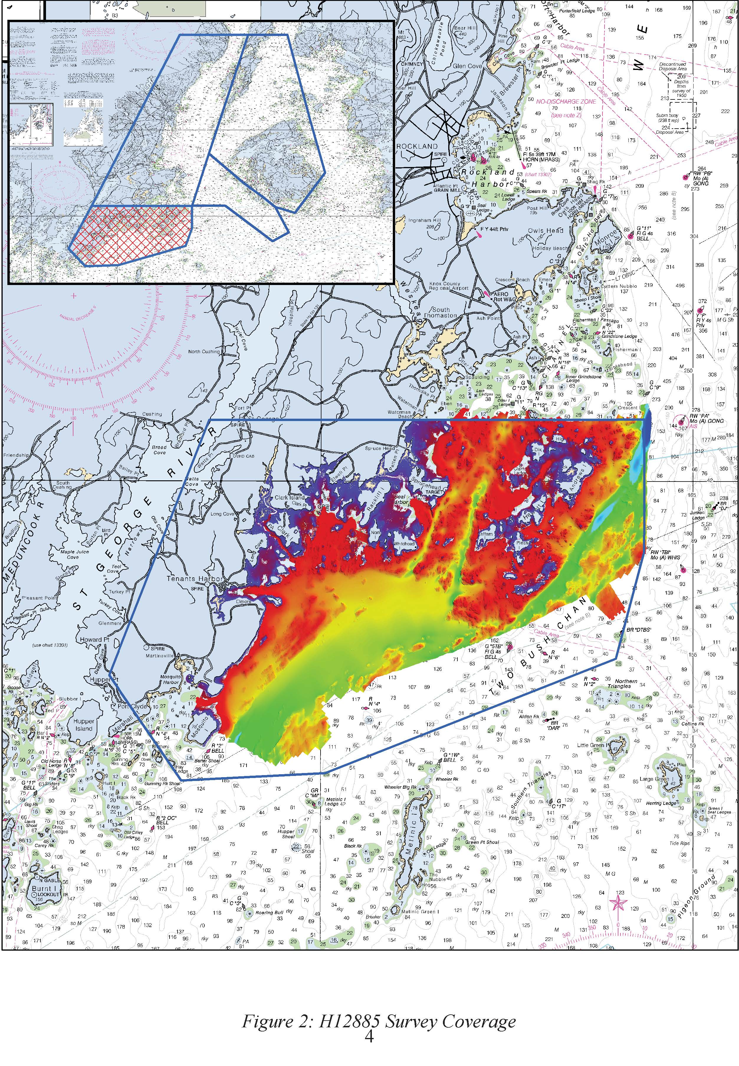
Federal
H12885: NOS Hydrographic Survey , 2016-09-29
National Oceanic and Atmospheric Administration, Department of Commerce —
The National Oceanic and Atmospheric Administration (NOAA) has the statutory mandate to collect hydrographic data in support of nautical chart compilation for safe... -
Federal
TIGER/Line Shapefile, 2022, State, Maine, ME, Elementary School Districts
U.S. Census Bureau, Department of Commerce —
The TIGER/Line shapefiles and related database files (.dbf) are an extract of selected geographic and cartographic information from the U.S. Census Bureau's Master... -
Federal
Katahdin Woods and Waters National Monument 4-Band Aerial Imagery Mosaics - TFG Unit
Department of the Interior —
Katahdin Woods and Waters National Monument was established on August 24, 2016. The monument spans mountains and forest lands in north central Maine. High-resolution... -
Federal
TIGER/Line Shapefile, Current, State, Maine, Unified School Districts
U.S. Census Bureau, Department of Commerce —
This resource is a member of a series. The TIGER/Line shapefiles and related database files (.dbf) are an extract of selected geographic and cartographic information... -
Federal
2020 Cartographic Boundary File (SHP), Current Elementary School District for Maine, 1:500,000
U.S. Census Bureau, Department of Commerce —
The 2020 cartographic boundary shapefiles are simplified representations of selected geographic areas from the U.S. Census Bureau's Master Address File /... -
Federal
Shoreline Mapping Program of WHITING BAY TO COBSCOOK BAY, ME, ME1001 NGDA
National Oceanic and Atmospheric Administration, Department of Commerce —
These data provide an accurate high-resolution shoreline compiled from imagery of WHITING BAY TO COBSCOOK BAY, ME . This vector shoreline data is based on an office... -
Federal
Estimated Annual Agricultural Pesticide Use by Major Crop or Crop Group for States of the Conterminous United States, 1992-2017 (ver. 2.0, May 2020)
Department of the Interior —
This data release provides state-level estimates of annual agricultural use of pesticide compounds by major crop or crop group for states in the conterminous United...

Official websites use .gov
A
.gov website belongs to an official government
organization in the United States.
Secure .gov websites use HTTPS
A
lock (
) or https:// means you’ve safely connected to
the .gov website. Share sensitive information only on official,
secure websites.