
-
Federal
SnowEx17 GPR and Lidar-Derived Snowpack Relative Permittivities and Densities V001
National Aeronautics and Space Administration —
This data set contains snowpack relative permittivities and densities derived from Ground Penetrating Radar (GPR) surveys and airborne lidar observations of snow... -
Federal
SENTINEL-1B_DUAL_POL_GRD_MEDIUM_RES
National Aeronautics and Space Administration —
Sentinel-1B Dual-pol ground projected medium resolution images -
Federal
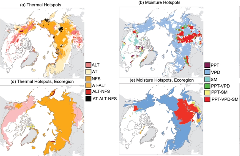
Trends of Thermal, Wetness, and Vegetative Change in the Circumpolar Arctic
National Aeronautics and Space Administration —
This dataset provides estimates of trends in temperature, moisture, and vegetation changes over the circumpolar Arctic. Time series trends were measured by the Theil-... -
Federal
SnowEx20 Community Snow Depth Probe Measurements V001
National Aeronautics and Space Administration —
This data set, collected during the SnowEx 2020 Intensive Operation Period (IOP) in Grand Mesa, Colorado, contains in situ snow depth measurements. Snow depth was... -
Federal
Global Landslide Proportional Economic Loss Risk Deciles
National Aeronautics and Space Administration —
The Global Landslide Proportional Economic Loss Risk Deciles is a 2.5 minute grid of landslide hazard economic loss as proportions of Gross Domestic Product (GDP) per... -
Federal
SnowEx20 Grand Mesa IOP Computed Tomography Snow Microstructure V001
National Aeronautics and Space Administration —
This data set characterizes snow microstructure for 6 snow pits from the SnowEx 2020 Grand Mesa Intensive Observation Period (February 2020) using microcomputed... -
Federal
ASO L4 Lidar Snow Depth 50m UTM Grid V001
National Aeronautics and Space Administration —
This data set contains 50 m gridded snow depths derived from airborne light detection and ranging, or lidar, measurements of surface elevations. The data were... -
Federal
MODIS/Aqua Snow Cover Daily L3 Global 0.05Deg CMG V061 NGDA
National Aeronautics and Space Administration —
This global Level-3 (L3) data set provides the percentage of snow-covered land and cloud-covered land observed daily, within 0.05° (approx. 5 km) MODIS Climate... -
Federal
SnowEx17 Radiometrics Surface-Based Radiometer Brightness Temperatures V001
National Aeronautics and Space Administration —
This data set consists of surface-based radiometer (SBR) brightness temperatures of the snow surface and vegetation at Grand Mesa, CO, USA, acquired during NASA's... -
Federal
SENTINEL-1A_SINGLE_POL_METADATA_GRD_HIGH_RES
National Aeronautics and Space Administration —
Sentinel-1A Single-pol ground projected high and full resolution metadata -
Federal
MEaSUREs Greenland Surface Melt Daily 25km EASE-Grid 2.0 V001
National Aeronautics and Space Administration —
This data set, part of the NASA Making Earth System Data Records for Use in Research Environments (MEaSUREs) program, offers users a 25 km daily record of... -
Federal
Global PyGEM-OGGM Glacier Projections with RCP and SSP Scenarios V001
National Aeronautics and Space Administration —
This data set comprises results from a hybrid glacier evolution model that uses the mass balance module of the Python Glacier Evolution Model (PyGEM) and the glacier... -
Federal
SnowEx23 Laser Snow Microstructure Specific Surface Area Data V001
National Aeronautics and Space Administration —
Preliminary: This data set reports vertical profiles of snow reflectance and specific surface area (SSA) in Alaska, USA, in two regions, the Fairbanks region... -
Federal
SENTINEL-1A_DUAL_POL_GRD_FULL_RES
National Aeronautics and Space Administration —
Sentinel-1A Dual-pol ground range detected full resolution images -
Federal
High Mountain Asia LIS Model Terrestrial Hydrological Parameters V001
National Aeronautics and Space Administration —
The data provided in this data set are simulated using the Noah-Multiparameterization Land Surface Model (Noah-MP LSM) Version 3.6 within the NASA Land Information... -
Federal
SnowEx17 Community Snow Depth Probe Measurements V001
National Aeronautics and Space Administration —
This data set, part of the SnowEx 2017 campaign, contains in situ snow depth measurements at two locations in Colorado, USA: Grand Mesa, a snow-covered, forested... -
Federal
AMSR-E/Aqua Monthly L3 Global Snow Water Equivalent EASE-Grids V002
National Aeronautics and Space Administration —
These Level-3 Snow Water Equivalent (SWE) data sets contain SWE data and quality assurance flags mapped to Northern and Southern Hemisphere 25 km Equal-Area Scalable... -
Federal
SnowEx23 Apr23 AVIRIS-NG Surface Spectral Reflectance V001
National Aeronautics and Space Administration —
This data set contains surface reflectance data collected from three boreal forest study sites (Delta Junction, Caribou Poker Creek watershed, and Farmer’s... -
Federal
MODIS/Aqua Snow Cover 8-Day L3 Global 500m SIN Grid V061 NGDA
National Aeronautics and Space Administration —
This global Level-3 (L3) data set provides the maximum snow cover extent (SNE) observed over an eight-day period within 10° x 10° MODIS sinusoidal grid tiles. Tiles... -
Federal
MODIS/Aqua Snow Cover Daily L3 Global 0.05Deg CMG V061 NGDA
National Aeronautics and Space Administration —
This global Level-3 (L3) data set provides the percentage of snow-covered land and cloud-covered land observed daily, within 0.05° (approx. 5 km) MODIS Climate...

Official websites use .gov
A
.gov website belongs to an official government
organization in the United States.
Secure .gov websites use HTTPS
A
lock (
) or https:// means you’ve safely connected to
the .gov website. Share sensitive information only on official,
secure websites.