
-
Federal
TROPICS06 Pathfinder L2B Instantaneous Surface Rain Rate (ISRR) V1.0
National Aeronautics and Space Administration —
The "Time-Resolved Observations of Precipitation structure and storm Intensity with a Constellation of Smallsats" (TROPICS) mission has a goal of providing nearly... -
Federal
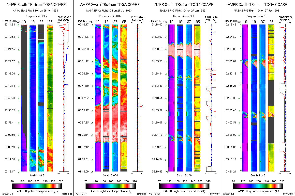
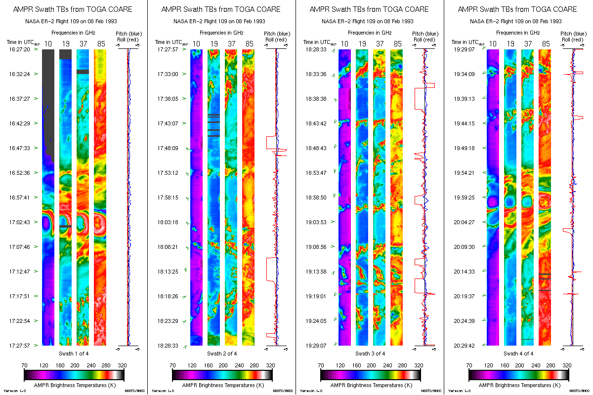
AMPR BRIGHTNESS TEMPERATURE (TB) TOGA COARE V2
National Aeronautics and Space Administration —
The Advanced Microwave Precipitation Radiometer (AMPR) data set was part of the atmospheric measurements collected during the intensive observation period of the... -
Federal
AMSR-E/Aqua Daily L3 12.5 km Brightness Temperature, Sea Ice Concentration, & Snow Depth Polar Grids V003
National Aeronautics and Space Administration —
This Level-3 gridded product (AE_SI12) includes brightness temperatures at 18.7 through 89.0 GHz, sea ice concentration, and snow depth over sea ice. -
Federal
Aquarius L2 Swath Single Orbit Soil Moisture V005
National Aeronautics and Space Administration —
This data set contains Level-2 global soil moisture estimates derived from the NASA Aquarius passive microwave radiometer on the Satélite de Aplicaciones Científicas... -
Federal
AMSR-E/AMSR2 Unified L3 Daily 25 km Brightness Temperatures & Sea Ice Concentration Polar Grids V001
National Aeronautics and Space Administration —
This data set reports average daily horizontally and vertically polarized brightness temperatures and sea ice concentrations on 25 km resolution north and south polar... -
Federal
Extended Special Sensor Microwave Imager (SSM/I) Sensor Data Record (SDR) in netCDF
National Oceanic and Atmospheric Administration, Department of Commerce —
The Special Sensor Microwave Imager (SSM/I) is a seven-channel linearly polarized passive microwave radiometer that operates at frequencies of 19.36 (vertically and... -
Federal
GPM GROUND VALIDATION CONICAL SCANNING MILLIMETER-WAVE IMAGING RADIOMETER (COSMIR) GCPEX V1
National Aeronautics and Space Administration —
The GPM Ground Validation Conical Scanning Millimeter-wave Imaging Radiometer (COSMIR) GCPEx dataset used the Conical Scanning Millimeter-wave Imaging Radiometer... -
Federal
MSU Ch 3/4 Daily Upper Troposphere Temps with Limb93 Correction V001 L3 1 day 2.5 degree x 2.5 degree (MSUUTT) at GES DISC
National Aeronautics and Space Administration —
The Microwave Sounding Unit (MSU) Upper Troposphere Temperature product (MSUUTT) provides gridded upper tropospheric temperatures derived from MSU instruments on... -
Federal
NOAA Climate Data Record (CDR) of AMSU-A Level 1c Brightness Temperature, Version 1.0
National Oceanic and Atmospheric Administration, Department of Commerce —
This dataset contains Level 1c inter-calibrated brightness temperatures from the Advanced Microwave Sounding Unit-A (AMSU-A) sensors onboard six polar orbiting... -
Federal
SMAP L1C Radiometer Half-Orbit 36 km EASE-Grid Brightness Temperatures V006
National Aeronautics and Space Administration —
This Level-1C (L1C) product contains calibrated and geolocated brightness temperatures acquired by the Soil Moisture Active Passive (SMAP) radiometer during 6:00 a.m.... -
Federal
TROPICS01 L2B Neural-network Atmospheric Vertical Temperature & Moisture Profiles V1.0
National Aeronautics and Space Administration —
The "Time-Resolved Observations of Precipitation structure and storm Intensity with a Constellation of Smallsats" (TROPICS) mission has a goal of providing nearly... -
Federal
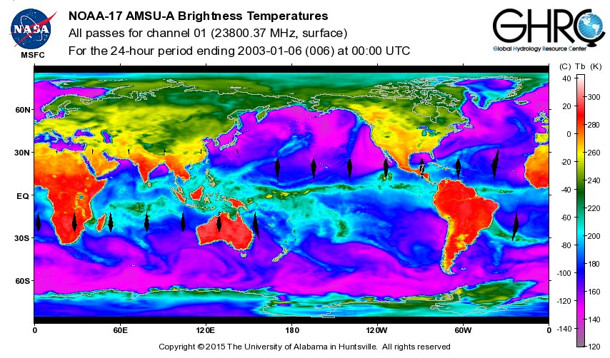
ADVANCED MICROWAVE SOUNDING UNIT-A (AMSU-A) SWATH FROM NOAA-17 V1
National Aeronautics and Space Administration —
AMSU-A, the Advanced Microwave Sounding Unit, is a 15-channel passive microwave radiometer used to profile atmospheric temperature and moisture from the earth's... -
Federal
TROPICS01 Pathfinder L2B Instantaneous Surface Rain Rate (ISRR) V1.0
National Aeronautics and Space Administration —
The "Time-Resolved Observations of Precipitation structure and storm Intensity with a Constellation of Smallsats" (TROPICS) mission has a goal of providing nearly... -
Federal
TROPICS07 L2B Neural-network Atmospheric Vertical Temperature & Moisture Profiles V0.2
National Aeronautics and Space Administration —
The "Time-Resolved Observations of Precipitation structure and storm Intensity with a Constellation of Smallsats" (TROPICS) mission has a goal of providing nearly... -
Federal
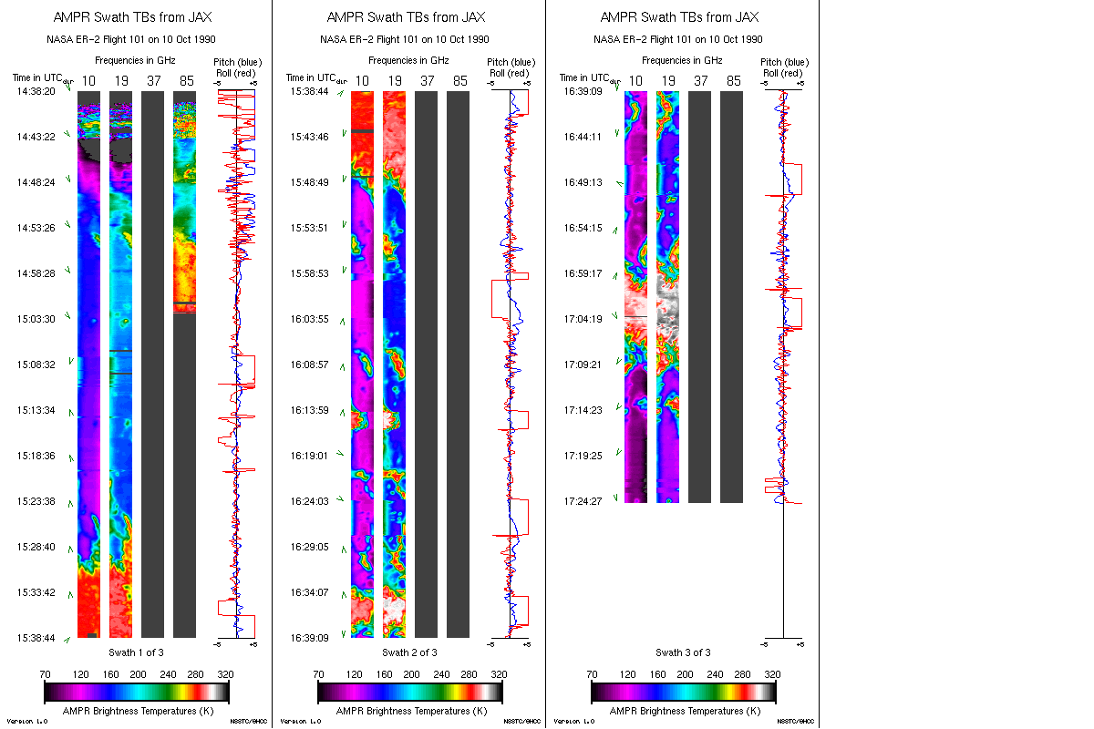
AMPR JACKSONVILLE BRIGHTNESS TEMPERATURE (TB) V2
National Aeronautics and Space Administration —
The Advanced Microwave Precipitation Radiometer (AMPR) was deployed in Jacksonville, FL for the initial AMPR instrument validation. AMPR data were collected at four... -
Federal
Nimbus-5 ESMR Polar Gridded Brightness Temperatures V002
National Aeronautics and Space Administration —
The Nimbus-5 Electrically Scanning Microwave Radiometer (ESMR) data set consists of gridded brightness temperature arrays for the Arctic and Antarctic, spanning 11... -
Federal
Special Sensor Microwave Imager/Sounder (SSMIS) Temperature Data Record (TDR) in netCDF
National Oceanic and Atmospheric Administration, Department of Commerce —
The Special Sensor Microwave Imager/Sounder (SSMIS) is a series of passive microwave conically scanning imagers and sounders onboard the DMSP satellites beginning... -
Federal
TOVS GLA MONTHLY GRIDS from NOAA-10 V01 (TOVSAMNG) at GES DISC
National Aeronautics and Space Administration —
This dataset (TOVSAMNG) contains the TIROS Operational Vertical Sounder (TOVS) level 3 geophysical parameters derived using data from NOAA-10 and the physical... -
Federal
BASE Temperature Data Record (TDR) from the SSM/I and SSMIS Sensors, CSU Version 1
National Oceanic and Atmospheric Administration, Department of Commerce —
The BASE Temperature Data Record (TDR) dataset from Colorado State University (CSU) is a collection of the raw unprocessed antenna temperature data that has been... -
Federal
SWOT Level 2 Radiometer Brightness Temperatures and Troposphere Operational Data Product Version 1.0
National Aeronautics and Space Administration —
The SWOT Level 2 Radiometer Brightness Temperatures and Troposphere Operational Geophysical Data Record (OGDR) Version 1.0 dataset produced by the Surface Water and...

Official websites use .gov
A
.gov website belongs to an official government
organization in the United States.
Secure .gov websites use HTTPS
A
lock (
) or https:// means you’ve safely connected to
the .gov website. Share sensitive information only on official,
secure websites.