
-
Federal
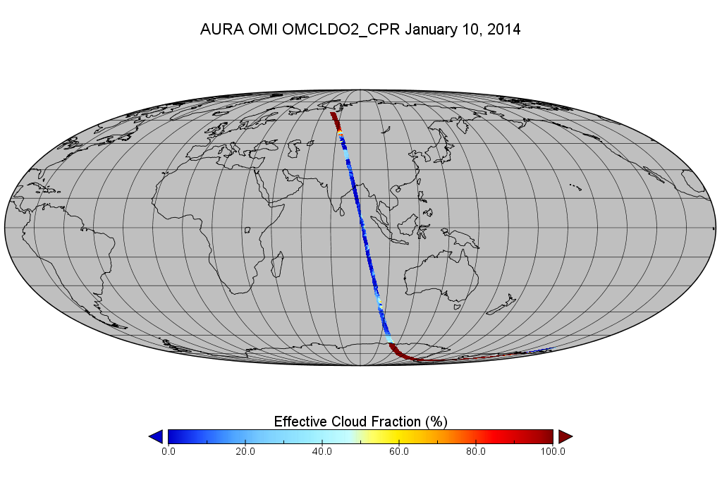
OMI/Aura Cloud Pressure and Fraction (O2-O2 Absorption) 200-km swath subset along CloudSat track V003 (OMCLDO2_CPR) at GES DISC
National Aeronautics and Space Administration —
This the OMI/Aura Cloud Pressure and Fraction (O2-O2 Absorption) subset along CloudSat track, for the purposes of the A-Train mission. The original product uses the... -
Federal
TOVS LMD 5 DAY GRIDS from NOAA-12 V01 (TOVSB5ND) at GES DISC
National Aeronautics and Space Administration —
Level 3 parameters from HIRS/2 and MSU radiances using the Improved Initialization Inversion (3I) classification retrieval scheme by the Laboratoire de Meteorologie... -
Federal
CERES MODIS Cloud Retrievals in ISCCP-D2like Format Nighttime Aqua FM4 Edition3A NGDA
National Aeronautics and Space Administration —
CER_ISCCP-D2like-Nit_Aqua-FM4-MODIS_Edition3A is the Clouds and the Earth's Radiant Energy System (CERES) Moderate Resolution Imaging Spectroradiometer (MODIS) Cloud... -
Federal
Cloud Regime for CRE Feedback Study
National Aeronautics and Space Administration —
Cloud-only regimes (and 3 sub-regimes of CR15) originally derived from Terra and Aqua observations in 50S-50N, and corresponding "regime numbers on map" files... -
Federal
Water Isotope System for Precipitation and Entrainment Research (WISPER) IMPACTS V1
National Aeronautics and Space Administration —
The Water Isotope System for Precipitation and Entrainment Research (WISPER) IMPACTS dataset consists of condensed water contents, water vapor measurements, and... -
Federal
GLAS/ICESat L2 Global Aerosol Vertical Structure Data (HDF5) V033
National Aeronautics and Space Administration —
GLAH10 Level-2 aerosol vertical structure data contain the attenuation-corrected cloud and aerosol backscatter and extinction profiles at a 4 sec sampling rate for... -
Federal
Level 1.5 Almucantar Inversion Products Phase Functions
National Aeronautics and Space Administration —
AERONET inversion code provides aerosoloptical properties in the total atmospheric column derived from the direct and diffuse radiation measured byAERONETCimel... -
Federal
Cloudmask, CLAVR-1, NOAA POES AVHRR, 0.0125 degrees, West US, 2007-present, Daytime (Single Scan), Lon+/-180
National Oceanic and Atmospheric Administration, Department of Commerce —
The CLAVR-1 cloudmask (Stowe, 1999) is used to cloudmask AVHRR high resolution sea surface temperature products. The cloudmask runs a series of tests on each surface... -
Federal
TOVS GLA 5 DAY GRIDS from NOAA-9 V01 (TOVSA5NF) at GES DISC
National Aeronautics and Space Administration —
This dataset (TOVSA5NF) contains the TIROS Operational Vertical Sounder (TOVS) level 3 geophysical parameters derived using data from NOAA-9 and the physical... -
Federal
Sol-Rad Net Flux (L 1.0, 1.5, 2.0)
National Aeronautics and Space Administration —
SolRad-Net (Solar Radiation Network) is an established network of ground-based sensors providing high-frequency solar flux measurements in quasi-realtime to the... -
Federal
International Satellite Cloud Climatology Project (ISCCP) B1 Uniform (B1U) Dataset
National Oceanic and Atmospheric Administration, Department of Commerce —
Data are collected from the suite of weather satellites operated by several nations and processed into B1 data by several groups in government agencies, laboratories,... -
Federal
Fast Longwave And SHortwave Fluxes (FLASHflux) Clouds and Radiative Swath (SSF) Aqua-FM3-MODIS data in HDF Version 4A
National Aeronautics and Space Administration —
FLASH_SSF_Aqua-FM3-MODIS_Version4A is the Fast Longwave And Shortwave Radiative Fluxes (FLASHFlux) Clouds and Radiative Swath (SSF) Aqua-FM3-MODIS data in HDF Version... -
Federal
Level 2.0 Almucantar Inversion Products (except phase functions)
National Aeronautics and Space Administration —
AERONET inversion code provides aerosoloptical properties in the total atmospheric column derived from the direct and diffuse radiation measured byAERONETCimel... -
Federal
Cloud Radar System (CRS) IMPACTS V1
National Aeronautics and Space Administration —
The Cloud Radar System (CRS) IMPACTS dataset consists of calibrated radar reflectivity, Doppler velocity, linear depolarization ratio, and normalized radar cross-... -
Federal
ATLAS/ICESat-2 L3A Calibrated Backscatter Profiles and Atmospheric Layer Characteristics Quick Look V006
National Aeronautics and Space Administration —
ATL09QL is the quick look version of ATL09. Once final ATL09 files are available the corresponding ATL09QL files will be removed. ATL09 contains calibrated,... -
Federal
POLDER/Parasol L2 Radiation Budget subset along CloudSat track V001 (PARASOLRB_CPR) at GES DISC
National Aeronautics and Space Administration —
This is the POLDER/Parasol Level-2 Radiation Budget Subset, collocated with the CloudSat track. The subset is processed at the A-Train Data Depot of the GES DISC,... -
Federal
AIRS/Aqua L2 Near Real Time (NRT) Standard Physical Retrieval (AIRS-only) V006 (AIRS2RET_NRT) at GES DISC
National Aeronautics and Space Administration —
The Atmospheric Infrared Sounder (AIRS) Level 2 Near Real Time (NRT) Standard Physical Retrieval (AIRS-only) product (AIRS2RET_NRT_006) differs from the routine... -
Federal
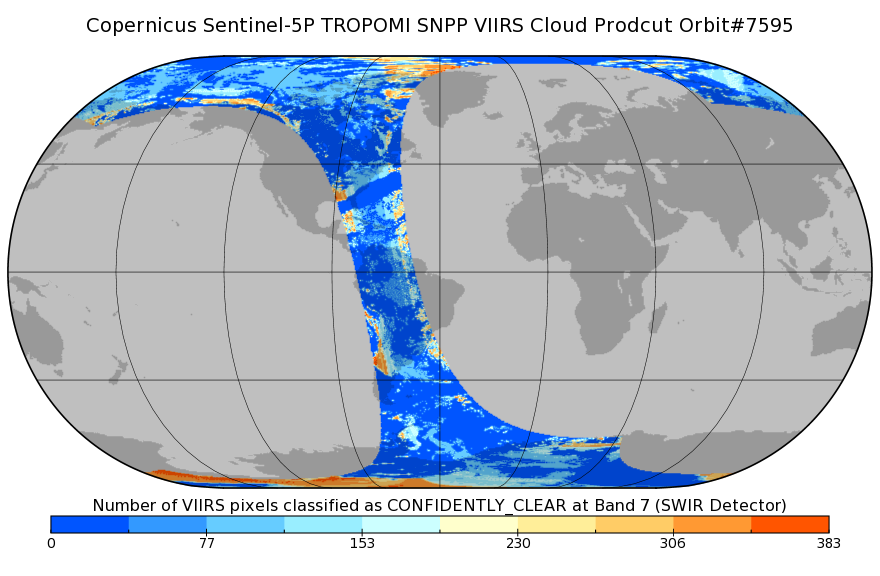
Sentinel-5P TROPOMI SNPP cloud product band 7 (SWIR detector) 1-Orbit L2 7km x 7km V1 (S5P_L2__NP_BD7) at GES DISC
National Aeronautics and Space Administration —
Starting from August 6th in 2019, Sentinel-5P TROPOMI along-track high spatial resolution (~5.5km at nadir) has been implemented. For data after August 6th of 2019,... -
Federal
TOVS LMD MONTHLY GRIDS from NOAA-12 V01 (TOVSBMND) at GES DISC
National Aeronautics and Space Administration —
Level 3 parameters from HIRS/2 and MSU radiances using the Improved Initialization Inversion (3I) classification retrieval scheme by the Laboratoire de Meteorologie... -
Federal
AMSR-E/AMSR2 Unified L3 Global Daily Ascending/Descending .25x.25 deg Ocean Grids V001
National Aeronautics and Space Administration —
The AMSR-E/AMSR2 Unified L3 Global Daily Ascending/Descending .25 x .25 deg Ocean Grids data set (AU_DyOcn) reports daily estimates of water vapor, cloud liquid water...

Official websites use .gov
A
.gov website belongs to an official government
organization in the United States.
Secure .gov websites use HTTPS
A
lock (
) or https:// means you’ve safely connected to
the .gov website. Share sensitive information only on official,
secure websites.