
-
Federal
2020 Cartographic Boundary File (SHP), Current Block Group for Maine, 1:500,000
U.S. Census Bureau, Department of Commerce —
The 2020 cartographic boundary shapefiles are simplified representations of selected geographic areas from the U.S. Census Bureau's Master Address File /... -
Federal
2010 State Profile — Maine
U.S. Department of Health & Human Services —
This state profile includes data from facilities in Maine that reported to N-SSATS for the survey reference date March 31, 2010. Data were collected on the location,... -
Federal
H08557: NOS Hydrographic Survey , LIbby Islands to Little River, Maine, 1960-08-25
National Oceanic and Atmospheric Administration, Department of Commerce —
The National Oceanic and Atmospheric Administration (NOAA) has the statutory mandate to collect hydrographic data in support of nautical chart compilation for safe... -
Federal
H02361: NOS Hydrographic Survey
National Oceanic and Atmospheric Administration, Department of Commerce —
The National Oceanic and Atmospheric Administration (NOAA) has the statutory mandate to collect hydrographic data in support of nautical chart compilation for safe... -
Federal
H07127: NOS Hydrographic Survey , 1947-12-31
National Oceanic and Atmospheric Administration, Department of Commerce —
The National Oceanic and Atmospheric Administration (NOAA) has the statutory mandate to collect hydrographic data in support of nautical chart compilation for safe... -
Federal
Physical, chemical, and biological oceanographic data collected for the ECOHAB (ECology and Oceanography of Harmful Algal Blooms) project from 1993 to 2006
National Oceanic and Atmospheric Administration, Department of Commerce —
This dataset includes physical, chemical, and biological oceanographic data including Karenia brevis counts, biochemistry, and behavior, chlorophyll, water... -
Federal
TIGER/Line Shapefile, Current, State, Maine, Point Landmark
U.S. Census Bureau, Department of Commerce —
The TIGER/Line shapefiles and related database files (.dbf) are an extract of selected geographic and cartographic information from the U.S. Census Bureau's Master... -
Federal
EnviroAtlas - Maximum Temperature 1950 - 2099 for the Conterminous United States
U.S. Environmental Protection Agency —
The EnviroAtlas Climate Scenarios were generated from NASA Earth Exchange (NEX) Downscaled Climate Projections (NEX-DCP30) ensemble averages (the average of over 30... -
Federal
Shoreline Data Rescue Project of Ogunquit to Prouts Neck Beach, Maine, ME2B02 NGDA
National Oceanic and Atmospheric Administration, Department of Commerce —
These data were automated to provide an accurate high-resolution historical shoreline of Ogunquit to Prouts Neck Beach, Maine suitable as a geographic information... -
Federal
An Unvegetated to Vegetated Ratio (UVVR) for coastal wetlands of the Atlantic Coast - 1999
Department of the Interior —
Prior research has shown that sediment budgets, and therefore stability, of microtidal marsh complexes scale with areal unvegetated to vegetated marsh ratios (UVVR)... -
Federal
2022 Cartographic Boundary File (KML), Current Elementary School District for Maine, 1:500,000
U.S. Census Bureau, Department of Commerce —
The 2022 cartographic boundary KMLs are simplified representations of selected geographic areas from the U.S. Census Bureau's Master Address File / Topologically... -
Federal
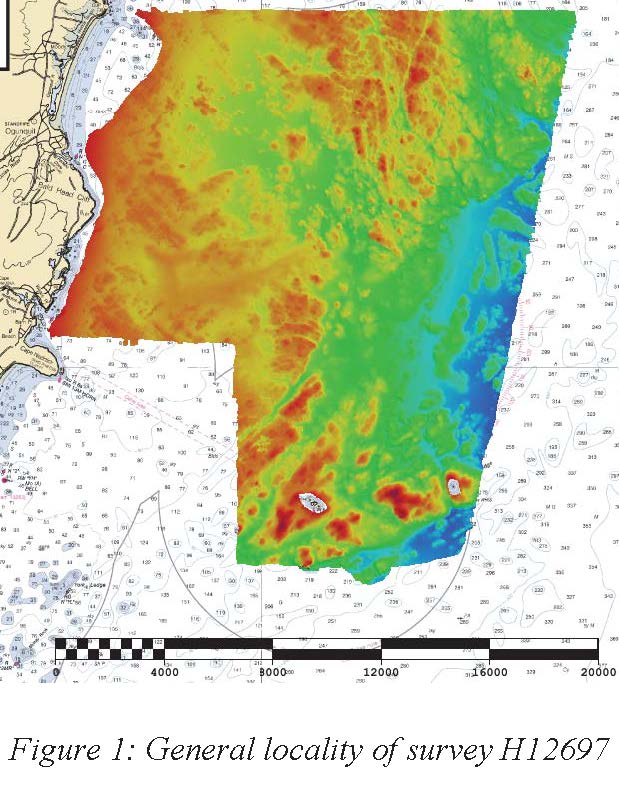
H12697: NOS Hydrographic Survey , Approaches to Portsmouth, NH, 2014-05-29
National Oceanic and Atmospheric Administration, Department of Commerce —
The National Oceanic and Atmospheric Administration (NOAA) has the statutory mandate to collect hydrographic data in support of nautical chart compilation for safe... -
Federal
EnviroAtlas - Portland, ME - Estimated Percent Green Space Along Walkable Roads
U.S. Environmental Protection Agency —
This EnviroAtlas dataset estimates green space along walkable roads. Green space within 25 meters of the road centerline is included and the percentage is based on... -
Federal
TIGER/Line Shapefile, 2021, State, Maine, 2020 Census Blocks
U.S. Census Bureau, Department of Commerce —
The TIGER/Line shapefiles and related database files (.dbf) are an extract of selected geographic and cartographic information from the U.S. Census Bureau's Master... -
Federal
2011 CMHS Uniform Reporting System (URS) Output Tables for Maine
U.S. Department of Health & Human Services —
Center for Mental Health Services (CMHS) Uniform Reporting System (URS) Output Tables for 2011. The Uniform Reporting System (URS) is a state and national reporting... -
Federal
H07834: NOS Hydrographic Survey , 1950-12-31
National Oceanic and Atmospheric Administration, Department of Commerce —
The National Oceanic and Atmospheric Administration (NOAA) has the statutory mandate to collect hydrographic data in support of nautical chart compilation for safe... -
Federal
Maine and New Hampshire 2016 BENTHIC Polygons
National Oceanic and Atmospheric Administration, Department of Commerce —
This data set contains sensitive biological resource data for benthic species in Maine and New Hampshire. Vector polygons in this data set represent submerged aquatic... -
Federal
EnviroAtlas - Portland, ME - Land Cover by Block Group
U.S. Environmental Protection Agency —
This EnviroAtlas dataset describes the percentage of each block group that is classified as impervious, forest, green space, wetland, and agriculture. Impervious is a... -
Federal
The LakeCat Dataset: Accumulated Attributes for NHDPlusV2 (Version 2.1) Catchments for the Conterminous United States: Dam Density and Storage Volume
U.S. Environmental Protection Agency —
This dataset represents the dam density and storage volumes within individual local and accumulated upstream catchments for NHDPlusV2 Waterbodies based on the... -
Federal
EnviroAtlas - MSPA connectivity with water as missing and 3-pixel edge width for the conterminous United States
U.S. Environmental Protection Agency —
This EnviroAtlas dataset categorizes land cover into structural elements (e.g. core, edge, connector, etc.). It depicts core areas of natural land cover, core...

Official websites use .gov
A
.gov website belongs to an official government
organization in the United States.
Secure .gov websites use HTTPS
A
lock (
) or https:// means you’ve safely connected to
the .gov website. Share sensitive information only on official,
secure websites.