
-
Federal
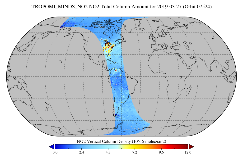
TROPOMI/S5P NO2 Tropospheric, Stratospheric and Total Columns MINDS 1-Orbit L2 Swath 5.5 km x 3.5 km V1.1 (TROPOMI_MINDS_NO2) at GES DISC
National Aeronautics and Space Administration —
As part of the NASA's Making Earth System Data Records for Use in Research Environments (MEaSUREs) program, this project entitled “Multi-Decadal Nitrogen Dioxide and... -
Federal
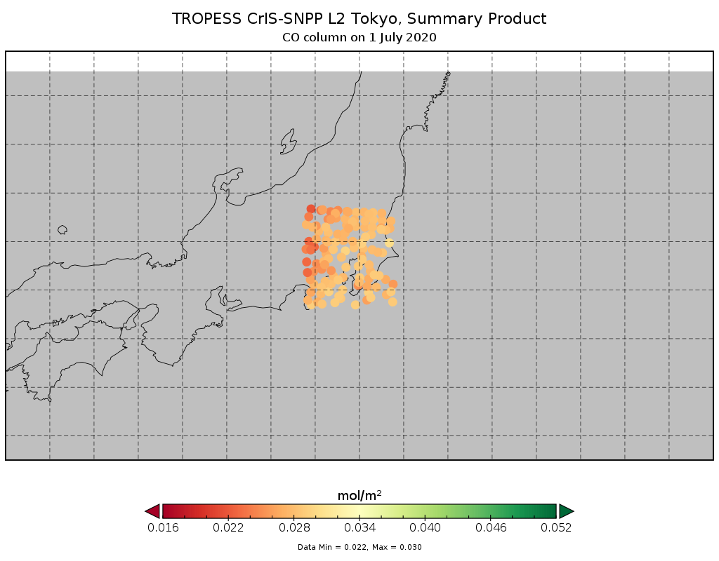
TROPESS CrIS-SNPP L2 for Tokyo Megacity, Summary Product V1 (TRPSYL2ALLCRSMGTOK) at GES DISC
National Aeronautics and Space Administration —
The TROPESS CrIS-SNPP L2 for Tokyo Megacity, Summary Product contains the vertical distribution of six retrieved atmospheric gases (CH4, CO, HDO, NH3, O3 and PAN),... -
Federal
TROPESS CrIS-SNPP L2 Peroxyacetyl Nitrate for Reanalysis Stream, Summary Product V1 (TRPSYL2PANCRSRS) at GES DISC
National Aeronautics and Space Administration —
The TROPESS CrIS-SNPP L2 Peroxyacetyl Nitrate for Reanalysis Stream, Summary Product contains the vertical distribution of the retrieved atmospheric state of... -
Federal
Primary Ancillary Data Geo-Colocated to OMI/Aura VIS 1-Orbit L2 Swath 13x24km V4 (OMVANC) at GES DISC
National Aeronautics and Space Administration —
The Primary Ancillary Data Geo-Colocated to OMI/Aura VIS 1-Orbit L2 Swath 13x24km (OMVANC) provides selected parameters from GEOS-5 Forward Processing for Instrument... -
Federal
Spatial Statistical Data Fusion (SSDF) Level 3: CONUS Near-Surface Atmospheric Temperature from Aqua AIRS, V2 (SNDRAQIL3SSDFCNSAT)
National Aeronautics and Space Administration —
This data set provides an estimate of the surface air temperature. It infers a value for each grid point based on nearby and distant values of the input Level-2... -
Federal
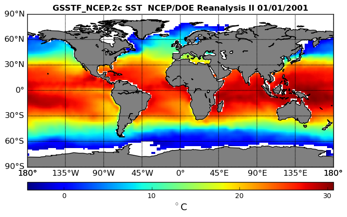
NCEP/DOE Reanalysis II in HDF-EOS5, for GSSTF2c, 1x1 deg Daily grid V2c (GSSTF_NCEP) at GES DISC
National Aeronautics and Space Administration —
These data are the Goddard Satellite-based Surface Turbulent Fluxes Version-2c (GSSTF2c) Dataset recently produced through a MEaSURES funded project led by Dr. Chung-... -
Federal
ATMOS L2 Trace Gases on Potential Temperature Grid, Fixed Field Format V3 (ATMOSL2TF) at GES DISC
National Aeronautics and Space Administration —
This is the version 3 Atmospheric Trace Molecule Spectroscopy (ATMOS) Level 2 product containing trace gases on a vertical potential temperature (theta) grid with... -
Federal
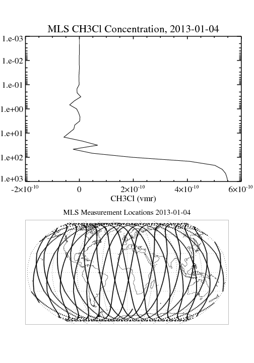
MLS/Aura Level 2 Methyl Chloride (CH3CL) Mixing Ratio V004 (ML2CH3CL) at GES DISC
National Aeronautics and Space Administration —
ML2CH3CL is the EOS Aura Microwave Limb Sounder (MLS) standard product for methyl chloride derived from radiances measured by the 640 GHz radiometer. The data version... -
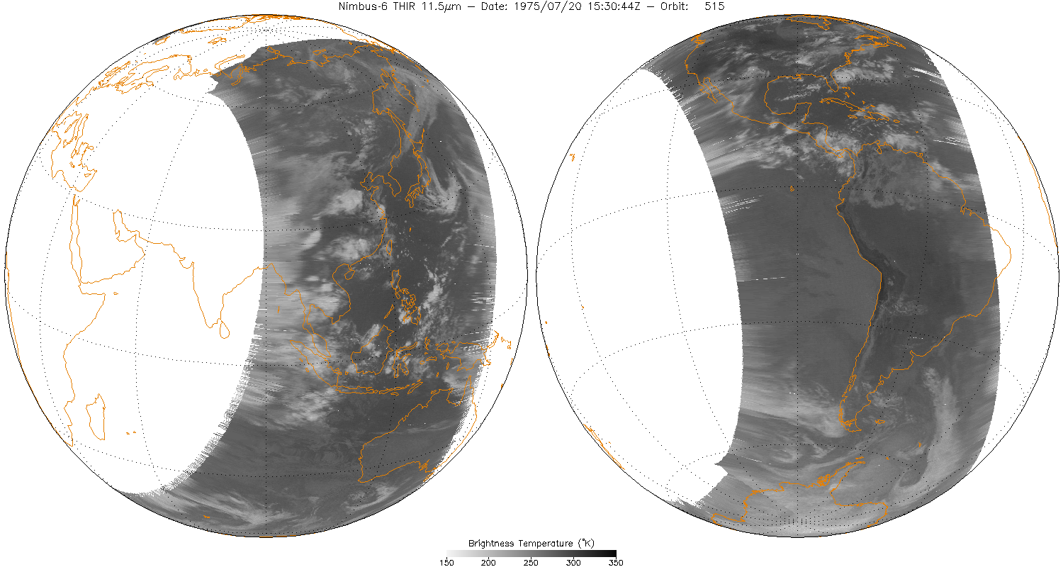
Federal
THIR/Nimbus-6 Level 1 Meteorological Radiation Data at 11.5 microns V001 (THIRN6L1CH115) at GES DISC
National Aeronautics and Space Administration —
THIRN6L1CH115 is the Nimbus-6 Temperature-Humidity Infrared Radiometer (THIR) Level 1 Meteorological Radiation Data at 11.5 microns product and contains radiances... -
Federal
NLDAS Secondary Forcing Data L4 Hourly 0.125 x 0.125 degree V2.0 (NLDAS_FORB0125_H) at GES DISC
National Aeronautics and Space Administration —
This data set contains the secondary forcing hourly data "File B" for Phase 2 of the North American Land Data Assimilation System (NLDAS-2). The data are in 1/8th... -
Federal
MODIS/Aqua Aerosol 5-Min L2 Swath Subset 10km along MLS V002 (MAM04S0) at GES DISC
National Aeronautics and Space Administration —
This is the MODIS/Aqua subset along MLS field of view track. The goal of the subset is to select and return MODIS data that are within +-100 km across the MLS track.... -
Federal
Sentinel-5P TROPOMI Near-Real-Time (NRT) Carbon Monoxide CO Column 1-Orbit L2 5.5km x 7km V2 (S5P_L2__CO_____HiR_NRT) at GES DISC
National Aeronautics and Space Administration —
The Sentinel-5P TROPOMI Near Real Time (NRT) Carbon Monoxide CO Column 1-Orbit L2 5.5km x 7km V2 (S5P_L2__CO_HiR_NRT) at GES DISC is the near real... -
Federal
TROPESS CrIS-JPSS1 L2 Peroxyacetyl Nitrate for Forward Stream, Summary Product V1 (TRPSYL2PANCRS1FS) at GES DISC
National Aeronautics and Space Administration —
The TROPESS CrIS-JPSS1 L2 Peroxyacetyl Nitrate for Forward Stream, Summary Product contains the vertical distribution of the retrieved atmospheric state of... -
Federal
Sounder SIPS: JPSS-1 CrIS Level 3 Specific Quality Control Gridded Daily CLIMCAPS V2 (SNDRJ1IML3SDCCP) at GES DISC
National Aeronautics and Space Administration —
WARNING: To users of the derived product “co_mmr_midtrop” (carbon monoxide mass mixing ratio to dry air [kg/kg] at ~500 hPa). This variable has a significant bias due... -
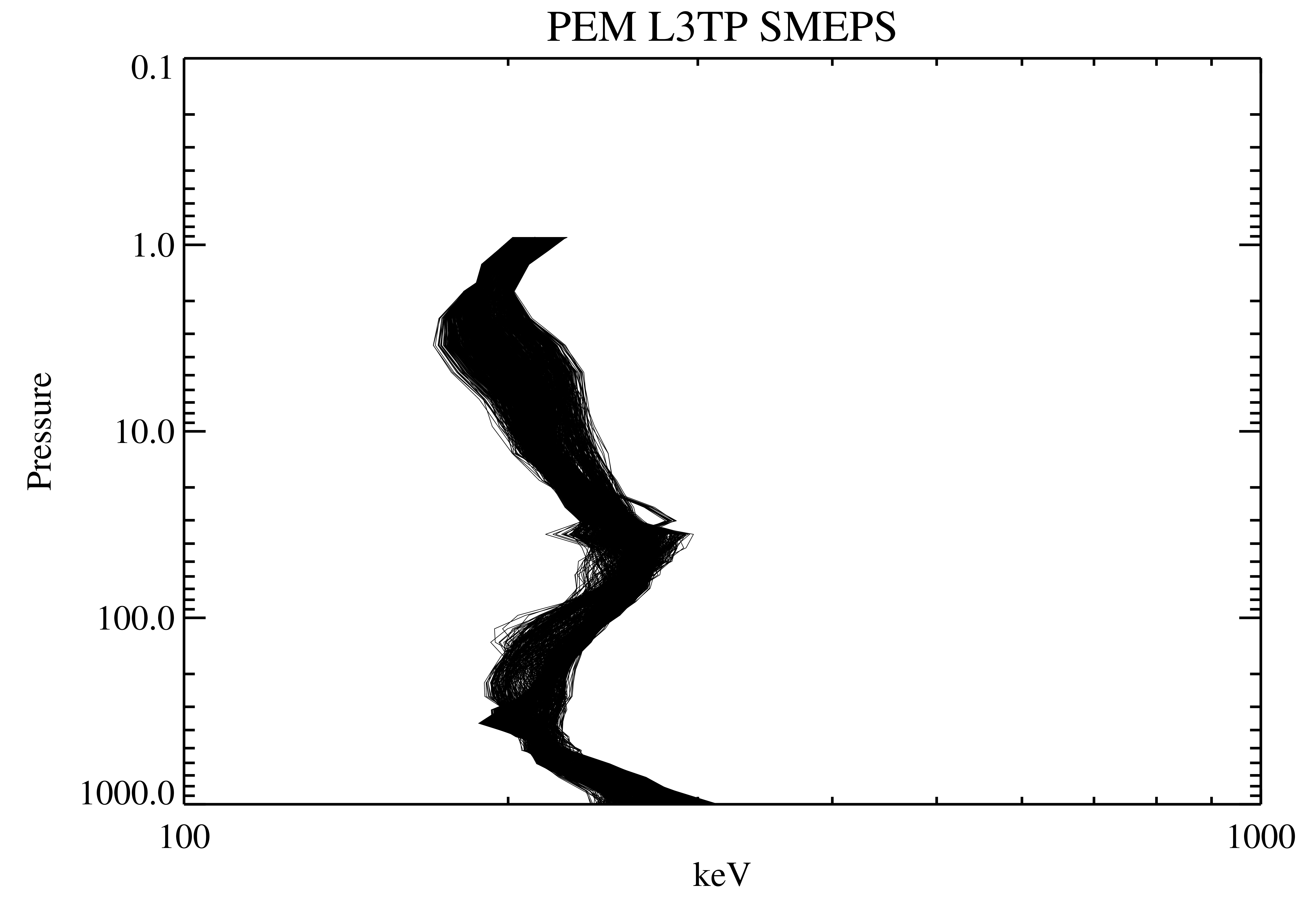
Federal
UARS PEM Level 2 AXIS 2 V001 (UARPE2AXIS2) at GES DISC
National Aeronautics and Space Administration —
The UARS Particle Environment Monitor (PEM) level 2 Atmosphere X-Ray Imaging Spectrometer (AXIS) unit 2 daily product contains the X-ray high-resolution spectral data... -
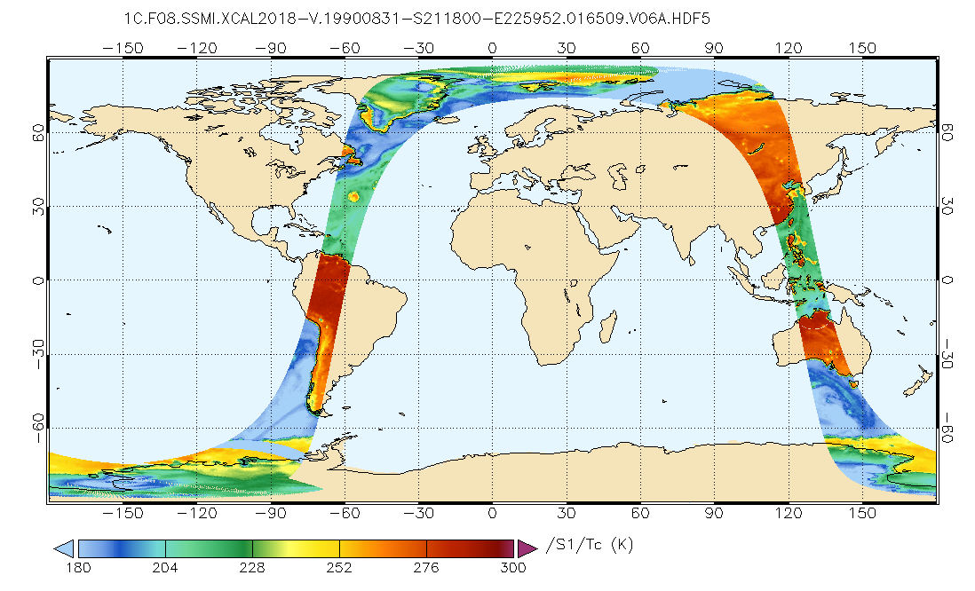
Federal
GPM SSMI on F08 Common Calibrated Brightness Temperatures L1C 1.5 hours 13 km V07 (GPM_1CF08SSMI) at GES DISC
National Aeronautics and Space Administration —
All 1C products have a common L1C data structure, simple and generic. Each L1C swath includes scan time, latitude and longitude, scan status, quality, incidence... -
Federal
TROPESS Chemical Reanalysis CO Spread 6-Hourly 3-dimensional Product V1 (TRPSCRCOS6H3D) at GES DISC
National Aeronautics and Space Administration —
The TROPESS Chemical Reanalysis CO Spread 6-Hourly 3-dimensional Product contains the carbon monoxide ensemble spread, a measure of data assimilation analysis... -
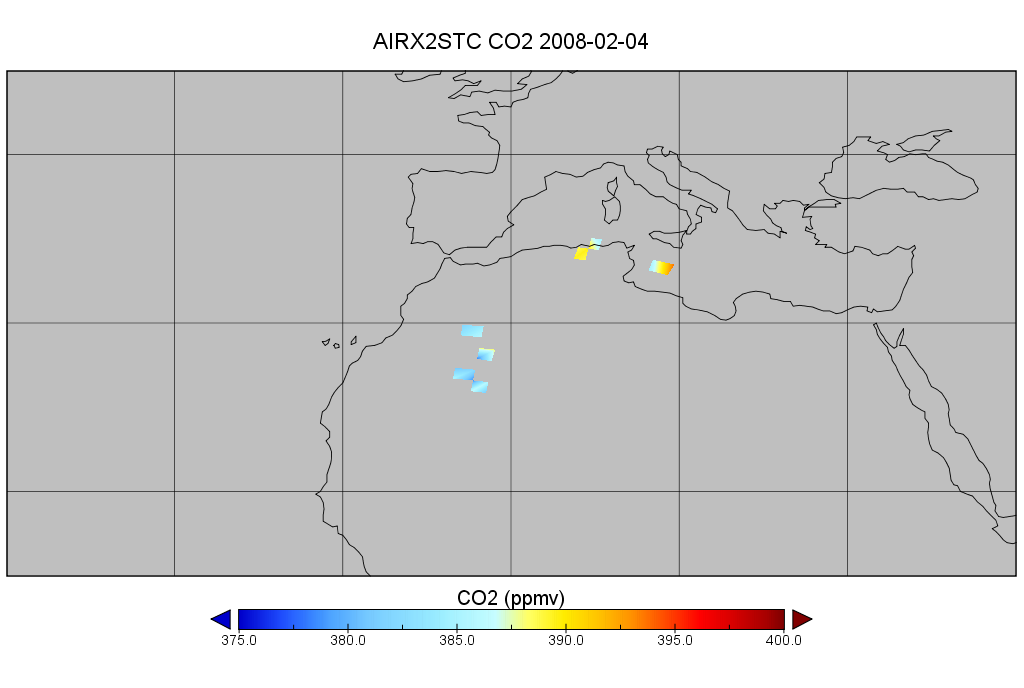
Federal
AIRS/Aqua L2 CO2 in the free troposphere (AIRS+AMSU) V005 (AIRX2STC) at GES DISC
National Aeronautics and Space Administration —
The Atmospheric Infrared Sounder (AIRS) is a grating spectrometer (R = 1200) aboard the second Earth Observing System (EOS) polar-orbiting platform, EOS Aqua. In... -
Federal
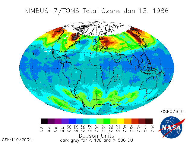
TOMS Nimbus-7 Total Column Ozone Daily L3 Global 1 deg x 1.25 deg Lat/Lon Grid V008 (TOMSN7L3dtoz) at GES DISC
National Aeronautics and Space Administration —
This Nimbus-7 Total Ozone Mapping Spectrometer (TOMS) version 8 daily global gridded data product contains total column ozone values. The data are mapped to a global... -
Federal
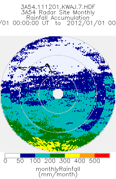
TRMM Ground Validation Radar Site Rain Type Totals Map L3 1 month 2 km V7 (TRMM_3A54) at GES DISC
National Aeronautics and Space Administration —
The 3A54 product, 'Site Rainfall Map', is a map of monthly surface rain totals derived from the instantaneous rain rate maps (2A53). The map is in Cartesian...

Official websites use .gov
A
.gov website belongs to an official government
organization in the United States.
Secure .gov websites use HTTPS
A
lock (
) or https:// means you’ve safely connected to
the .gov website. Share sensitive information only on official,
secure websites.