
-
Federal
Modeled Thickness of the Grande Ronde Basalt Geomodel Unit (grthk_f)
Department of the Interior —
The grthk_f grid represents the modeled thickness of the Gronde Ronde Basalt geomodel unit at a 500 foot resolution. It is one grid of a geomodel that consists of... -
Federal
EnviroAtlas - 2011 Land Cover, Impervious Surface, and Riparian Land Cover Proportions by 12-digit HUC for the Conterminous United States
U.S. Environmental Protection Agency —
This EnviroAtlas dataset represents land cover across a watershed and in riparian areas for each 12-digit hydrologic unit code (HUC) in the conterminous United States... -
Federal
TIGER/Line Shapefile, 2024, County, Idaho County, ID, Address Ranges Relationship File
U.S. Census Bureau, Department of Commerce —
The TIGER/Line shapefiles and related database files (.dbf) are an extract of selected geographic and cartographic information from the U.S. Census Bureau's Master... -
Federal
The LakeCat Dataset: Accumulated Attributes for NHDPlusV2 (Version 2.1) Catchments for the Conterminous United States: 2010 US Census Housing Unit and Population Density
U.S. Environmental Protection Agency —
This dataset represents the population and housing unit density within individual local and accumulated upstream catchments for NHDPlusV2 Waterbodies based on the... -
Federal
Streamflow statistics for selected streamgages in and near Wyoming through water year 2021
Department of the Interior —
The U.S. Geological Survey (USGS), in cooperation with the Wyoming Water Development Office, developed streamflow statistics for active (through September 30, 2021)... -
Federal
NOAA/WDS Paleoclimatology - Biondi - Salmon River Valley - PSME - ITRDB ID014
National Oceanic and Atmospheric Administration, Department of Commerce —
This archived Paleoclimatology Study is available from the NOAA National Centers for Environmental Information (NCEI), under the World Data Service (WDS) for... -
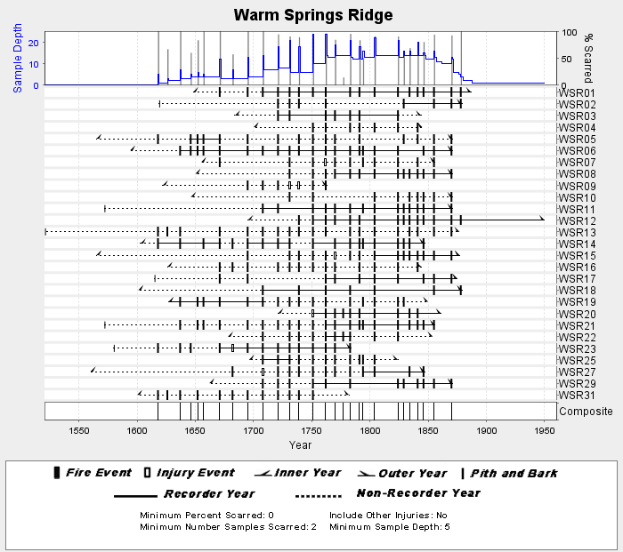
Federal
NOAA/WDS Paleoclimatology - Heyerdahl fire data from Warm Springs Ridge - IMPD USWSR001
National Oceanic and Atmospheric Administration, Department of Commerce —
This archived Paleoclimatology Study is available from the NOAA National Centers for Environmental Information (NCEI), under the World Data Service (WDS) for... -
Federal
TIGER/Line Shapefile, 2021, County, Jerome County, ID, All Roads
U.S. Census Bureau, Department of Commerce —
The TIGER/Line shapefiles and related database files (.dbf) are an extract of selected geographic and cartographic information from the U.S. Census Bureau's Master... -
Federal
2006 PM-2.5 Nonattainment Areas
U.S. Environmental Protection Agency —
This data layer identifies areas in the U.S. where air pollution levels have not met the National Ambient Air Quality Standards (NAAQS) for 2006 PM-2.5 standards.... -
Federal
Early Estimates of Exotic Annual Grass (EAG) in the Sagebrush Biome, USA, 2022 (ver 6.0, July 2022)
Department of the Interior —
These datasets provide early estimates of 2022 fractional cover for exotic annual grass (EAG) species and one native perennial grass species on a bi-weekly basis from... -
Federal
Changes in the potentiometric-surface altitude of the confined aquifer, Wood River Valley aquifer system, south-central Idaho, October 2006 to October 2012.
Department of the Interior —
Water levels in 93 wells completed in the Wood River Valley aquifer system were measured during October 22–24, 2012; these wells are part of a network established by... -
Federal
Greater sage-grouse population structure (moderate-scaled, tier three) in the western United States
Department of the Interior —
This data, grsg_lcp_ThiessenPoly_mst3, is one of five hierarchical delineations of greater sage-grouse population structure. The data represent Thiessen polygons of... -
Federal
Mercury in smallmouth bass from the Snake River, USA (ver. 2.0, January 2025)
Department of the Interior —
Comma-separated values (.csv) file containing data related to mercury in smallmouth bass (Micropterus dolomieu) collected from the Snake River, USA. -
Federal
TIGER/Line Shapefile, 2024, County, Idaho County, ID, Address Range-Feature
U.S. Census Bureau, Department of Commerce —
The TIGER/Line shapefiles and related database files (.dbf) are an extract of selected geographic and cartographic information from the U.S. Census Bureau's Master... -
Federal
The LakeCat Dataset: Accumulated Attributes for NHDPlusV2 (Version 2.1) Catchments for the Conterminous United States: Canal Density
U.S. Environmental Protection Agency —
This dataset represents canal density within individual, local and accumulated upstream catchments for NHDPlusV2 Waterbodies. Catchment boundaries in LakeCat are... -
Federal
Sample collection information and microsatellite data for Northern Black Swifts in 6 colonies across Colorado, New Mexico and Idaho
Department of the Interior —
This dataset contains sample collection information and microsatellite genotype data for Northern Black Swifts in 6 colonies across Colorado, New Mexico and Idaho.... -
Federal
The LakeCat Dataset: Accumulated Attributes for NHDPlusV2 (Version 2.1) Catchments for the Conterminous United States: Nonnative LANDFIRE Vegetation
U.S. Environmental Protection Agency —
This dataset represents the average height of the dominant vegetation for a 30-m grid cell within individual local and accumulated upstream catchments for NHDPlusV2... -
Federal
Early Estimates of Exotic Annual Grass (EAG) in the Sagebrush Biome, USA, 2023 (ver. 4.0, May 2023)
Department of the Interior —
These datasets provide early estimates of 2023 fractional cover for exotic annual grass (EAG) species and one native perennial grass species on a weekly basis from... -
Federal
TIGER/Line Shapefile, 2023, State, Idaho, ID, Block Group
U.S. Census Bureau, Department of Commerce —
The TIGER/Line shapefiles and related database files (.dbf) are an extract of selected geographic and cartographic information from the U.S. Census Bureau's Master... -
Federal
US EPA Nonattainment Areas and Designations-8 Hour Ozone (2015 NAAQS) - Web Service Layer
U.S. Environmental Protection Agency —
This web service layer, Ozone 8-hr (2015 standard), displays identified state level areas where ground-level ozone have not met the National Ambient Air Quality...

Official websites use .gov
A
.gov website belongs to an official government
organization in the United States.
Secure .gov websites use HTTPS
A
lock (
) or https:// means you’ve safely connected to
the .gov website. Share sensitive information only on official,
secure websites.