
-
Federal
TRMM PR Gridded Orbital Spectral Latent Heating Profiles L3 1.5 hours 0.5 degree x 0.5 degree V7 (TRMM_3G25) at GES DISC
National Aeronautics and Space Administration —
3G25, "Gridded Orbital Spectral Latent Heating", produces 0.5 degree x 0.5 degree latent heating, Q1-QR, and Q2 profiles from Precipitation Radar (PR) rain. The... -
Federal
Goddard Satellite-Based Surface Turbulent Fluxes, 1x1 deg Yearly Climatology, Set1 and NCEP V2c (GSSTFYC) at GES DISC
National Aeronautics and Space Administration —
These data are the Goddard Satellite-based Surface Turbulent Fluxes Version-2c Dataset recently produced through a MEaSURES funded project led by Dr. Chung-Lin Shie... -
Federal
HIRDLS/Aura Level 3 Geopotential Height 1deg Lat Zonal Fourier Coefficients V007 (H3ZFCGPH) at GES DISC
National Aeronautics and Space Administration —
The "HIRDLS/Aura Level 3 Geopotential Height Zonal Fourier Coefficients" version 7 data product (H3ZFCGPH) contains the entire mission (~3 years) of HIRDLS data... -
Federal
OMI/Aura TOMS-Like Ozone, Aerosol Index, Cloud Radiance Fraction L3 1 day 1 degree x 1 degree V004 (OMTO3d) at GES DISC
National Aeronautics and Space Administration —
The OMI science team produces this Level-3 daily global TOMS-Like Total Column Ozone gridded product OMTO3d (1 deg Lat/Lon grids). The OMTO3d product is produced by... -
Federal
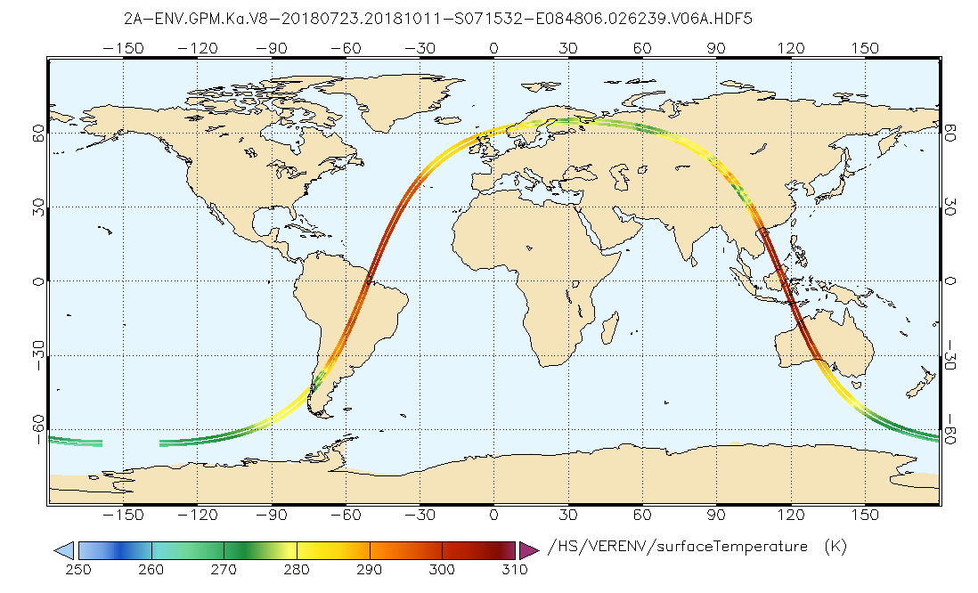
GPM DPR Ka Environment L2A 1.5 hours 5 km V07 (GPM_2AKaENV) at GES DISC
National Aeronautics and Space Administration —
Version 07 is the current version of the data set. Older versions will no longer be available and have been superseded by Version 07. . This is environmental data... -
Federal
CAR SCAR-B Smoke, Clouds, and Radiation-Brazil L1 V1 (CAR_SCARB_L1C) at GES DISC
National Aeronautics and Space Administration —
The objectives for the SCAR mission are to advance our knowledge of how the physical, chemical and radiative processes in our atmosphere are affected by sulfate... -
Federal
GPM SSMIS on F18 (GPROF) Climate-based Radiometer Precipitation Profiling L3 1 month 0.25 degree x 0.25 degree V07 (GPM_3GPROFF18SSMIS_CLIM) at GES DISC
National Aeronautics and Space Administration —
Version 07 is the current version of the data set. Older versions will no longer be available and have been superseded by Version 07. The "CLIM" products differ from... -
Federal
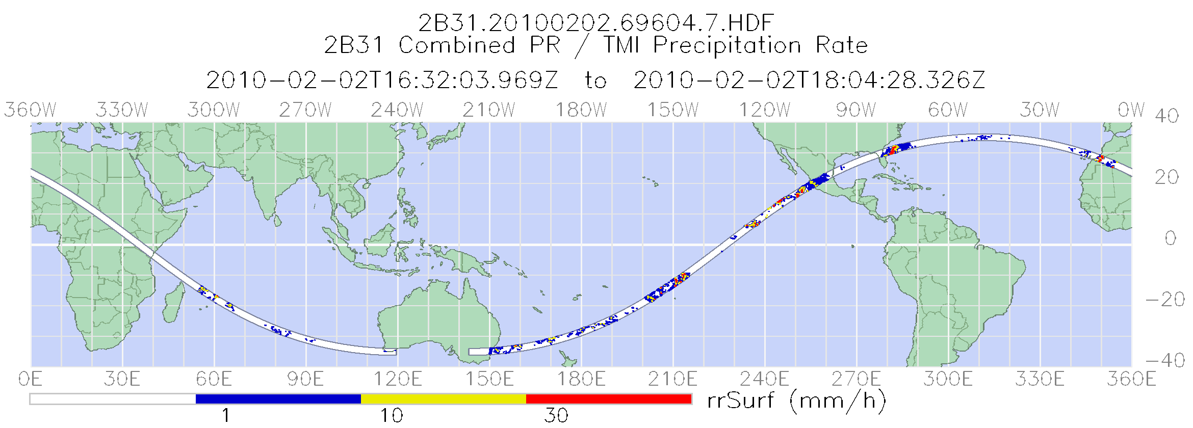
TRMM Combined Precipitation Radar and Microwave Imager Rainfall Profile L2 1.5 hours V7 (TRMM_2B31) at GES DISC
National Aeronautics and Space Administration —
This is the last version of the TRMM-formatted, in HDF4 format, Combined (Radar-Radiometer) product, which is in a state of permanent preservation. New version that... -
Federal
SBUV2/NOAA-11 Level 2 Daily Ozone Profile and Total Column from CD-ROM V008 (SBUV2N11O3) at GES DISC
National Aeronautics and Space Administration —
The version 8 SBUV/2 NOAA-11 ozone data were first released at the 2004 Quadrennial Ozone Symposium on DVD. The DVD contained all of the SBUV/2 data from NOAA-9,... -
Federal
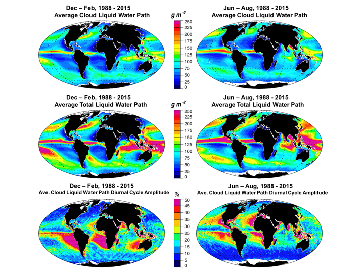
Multisensor Advanced Climatology Mean Liquid Water Path Diurnal Cycle L3 Monthly 1 degree x 1 degree V1 (MACLWP_diurnal) at GES DISC
National Aeronautics and Space Administration —
The Multi-Sensor Advanced Climatology of Liquid Water Path (MAC-LWP) data set contains monthly 1.0-degree ocean-only estimates of cloud liquid water path... -
Federal
TROPESS CrIS-SNPP L2 Peroxyacetyl Nitrate for West Coast Fires HiRes, Standard Product V1 (TRPSDL2PANCRSWCFHI) at GES DISC
National Aeronautics and Space Administration —
The TROPESS CrIS-SNPP L2 Peroxyacetyl Nitrate for West Coast Fires HiRes, Standard Product contains the vertical distribution of the retrieved atmospheric state of... -
Federal
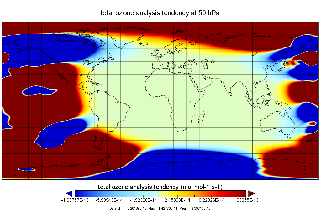
MERRA-2 tavgU_3d_odt_Np: 3d,diurnal,Time-Averaged,Pressure-Level,Assimilation,Ozone Tendencies 0.625 x 0.5 degree V5.12.4 (M2TUNPODT) at GES DISC
National Aeronautics and Space Administration —
M2TUNPODT (or tavgU_3d_odt_Np) is a 3-dimensional monthly diurnal means data collection in Modern-Era Retrospective analysis for Research and Applications version 2... -
Federal
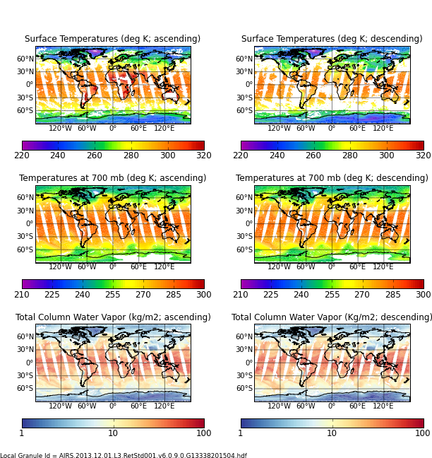
AIRS/Aqua L3 Daily Support Product (AIRS+AMSU) 1 degree x 1 degree V006 (AIRX3SPD) at GES DISC
National Aeronautics and Space Administration —
The Atmospheric Infrared Sounder (AIRS) is a grating spectrometer (R = 1200) aboard the second Earth Observing System (EOS) polar-orbiting platform, EOS Aqua. In... -
Federal
Aqua AIRS-MODIS 1-km Matchup Indexes V1 (Aqua_AIRS_MODIS1km_IND) at GES_DISC
National Aeronautics and Space Administration —
This dataset includes Aqua AIRS to MODIS 1-km collocation index product, within the framework of the Multidecadal Satellite Record of Water Vapor, Temperature, and... -
Federal
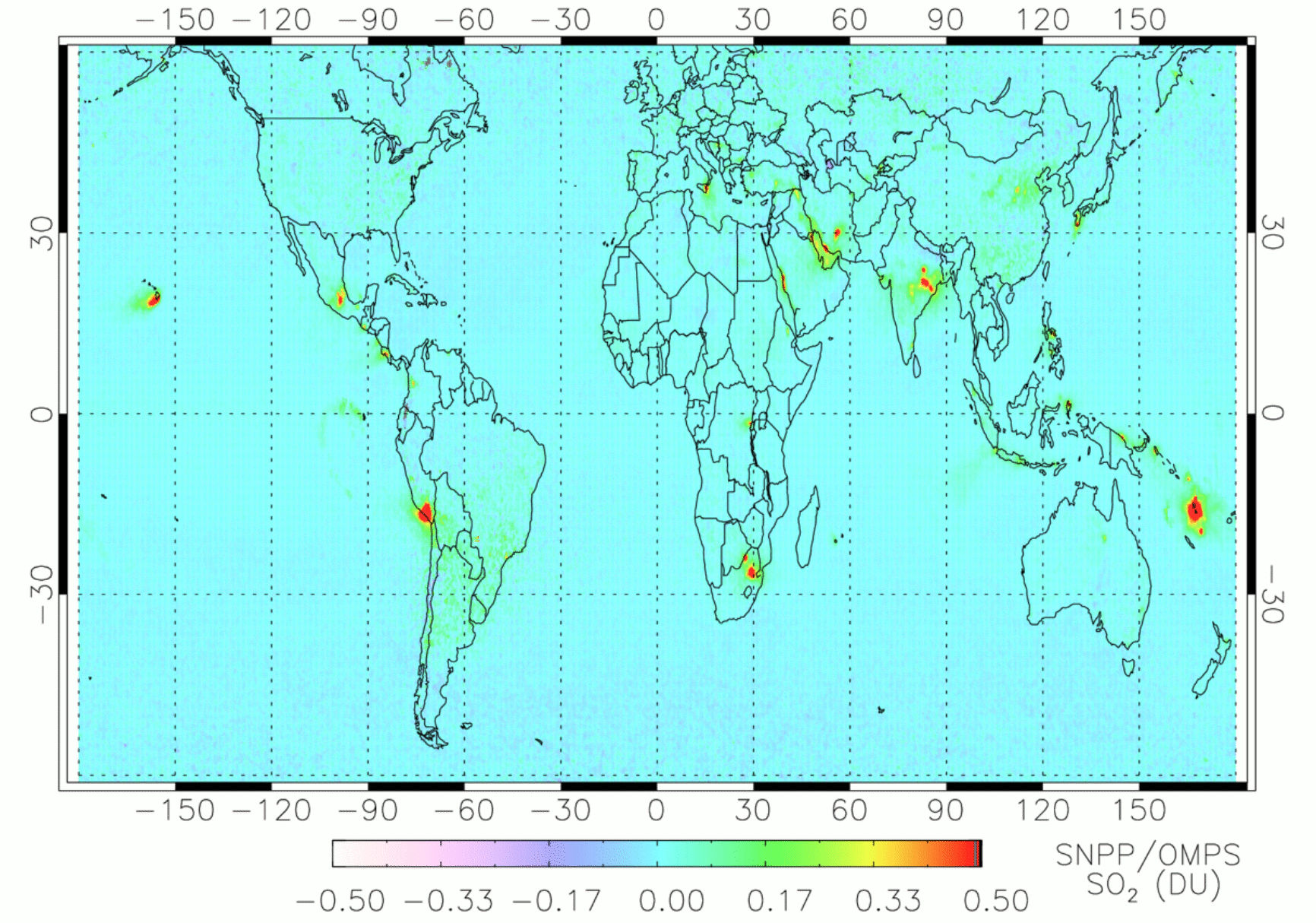
OMPS/NPP PCA SO2 Total Column 1-Orbit L2 Swath 50x50km V2 (OMPS_NPP_NMSO2_PCA_L2) at GES DISC
National Aeronautics and Space Administration —
The OMPS_NPP_NMSO2_PCA_L2 product is part of the MEaSUREs (Making Earth Science Data Records for Use in Research Environments) suite of products. It is retrieved from... -
Federal
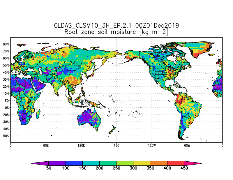
GLDAS Catchment Land Surface Model L4 3 hourly 1.0 x 1.0 degree Early Product V2.1 (GLDAS_CLSM10_3H_EP) at GES DISC
National Aeronautics and Space Administration —
NASA Global Land Data Assimilation System Version 2 (GLDAS-2) has three components: GLDAS-2.0, GLDAS-2.1, and GLDAS-2.2. GLDAS-2.0 is forced entirely with the... -
Federal
TROPESS CrIS-SNPP L2 for Los Angeles Megacity, Summary Product V1 (TRPSYL2ALLCRSMGLOS) at GES DISC
National Aeronautics and Space Administration —
The TROPESS CrIS-SNPP L2 for Los Angeles Megacity, Summary Product contains the vertical distribution of six retrieved atmospheric gases (CH4, CO, HDO, NH3, O3 and... -
Federal
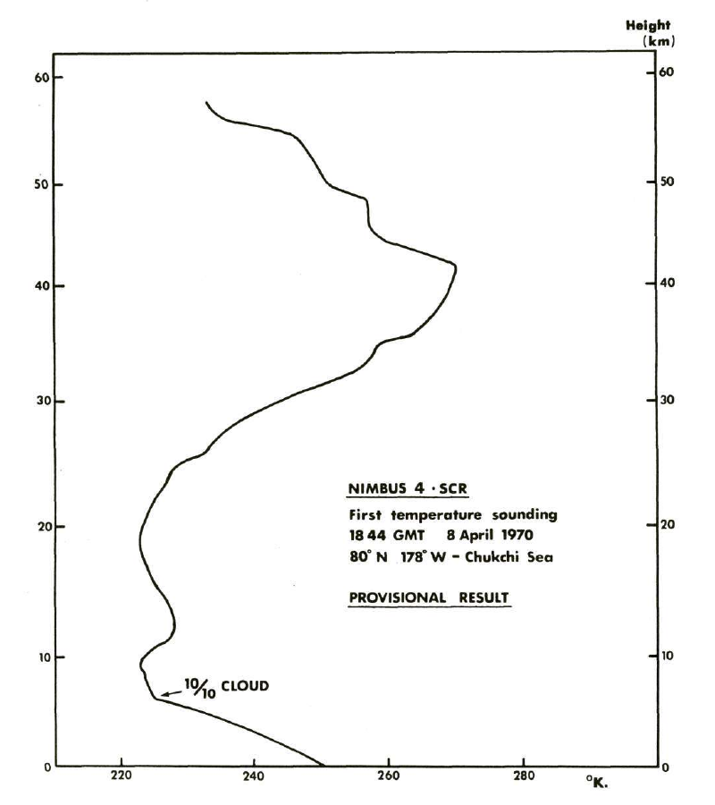
SCR/Nimbus-4 Level 1 Radiance Data from CD-ROM V001 (SCRN4L1RAD_CDROM) at GES DISC
National Aeronautics and Space Administration —
SCRN4L1RAD_CDROM is the gridded Nimbus-4 Selective Chopper Radiometer (SCR) Level 1 Radiance Data Product. The radiances are measured by 16 channels at 2.3 to 15... -
Federal
OCO-3 Level 2 CO2 prior based on CO2 monthly flask record, global meteorology, and age of air, Forward Processing V10 (OCO3_L2_CO2Prior) at GES DISC
National Aeronautics and Space Administration —
Version 10 is the current version of the data set. Older versions will no longer be available and are superseded by Version 10. The Orbiting Carbon Observatory -3... -
Federal
TROPESS CrIS-SNPP L2 for Karachi Megacity, Summary Product V1 (TRPSYL2ALLCRSMGKAR) at GES DISC
National Aeronautics and Space Administration —
The TROPESS CrIS-SNPP L2 for Karachi Megacity, Summary Product contains the vertical distribution of six retrieved atmospheric gases (CH4, CO, HDO, NH3, O3 and PAN),...

Official websites use .gov
A
.gov website belongs to an official government
organization in the United States.
Secure .gov websites use HTTPS
A
lock (
) or https:// means you’ve safely connected to
the .gov website. Share sensitive information only on official,
secure websites.