
-
Federal
MEaSUREs InSAR-Based Ice Velocity Maps of Central Antarctica: 1997 and 2009 V001
National Aeronautics and Space Administration —
This data set, part of the NASA Making Earth System Data Records for Use in Research Environments (MEaSUREs) program, consists of two high-resolution digital mosaics... -
Federal
MODIS/Aqua Snow Cover Monthly L3 Global 0.05Deg CMG V061 NGDA
National Aeronautics and Space Administration —
This global Level-3 (L3) data set provides monthly average snow cover within 0.05° (approx. 5 km) MODIS Climate Modeling Grid (CMG) cells. Monthly averages are... -
Federal
VIIRS/NPP Snow Cover Daily L3 Global 375m SIN Grid V001
National Aeronautics and Space Administration —
This data set contains daily snow cover derived from radiance data acquired by the Visible Infrared Imaging Radiometer Suite (VIIRS) on board the Suomi National... -
Federal
VIIRS/NPP CGF Snow Cover Daily L3 Global 375m SIN Grid V002
National Aeronautics and Space Administration —
This data set contains daily 'cloud-free' snow cover produced from the VIIRS/NPP Snow Cover Daily L3 Global 375m SIN Grid, Version 2 snow cover product. A cloud-gap-... -
Federal
SnowEx17 Ground Penetrating Radar V002
National Aeronautics and Space Administration —
This data set contains the results of a ground penetrating radar survey conducted at Grand Mesa, Colorado. Data include the two-way travel time, calculated snow... -
Federal
SnowEx17 Time Series Sonic Snow Depth Measurement Array V001
National Aeronautics and Space Administration —
This data set contains 15-min snow depth observations for two study sites on Grand Mesa, CO, USA, acquired as part of NASA's 2017 SnowEx campaign. The data were... -
Federal
SnowEx17 Community Snow Pit Measurements V001
National Aeronautics and Space Administration —
This data set contains measurements of snow temperature, density, stratigraphy, grain size, wetness, depth, and snow water equivalent (SWE) for snow pits at two study... -
Federal
SENTINEL-1B_METADATA_OCN
National Aeronautics and Space Administration —
Sentinel-1B Metadata for OCN product -
Federal
ASO L4 Lidar Snow Water Equivalent 50m UTM Grid V001
National Aeronautics and Space Administration —
This data set contains 50 m gridded snow water equivalent (SWE) values collected as part of the NASA/JPL Airborne Snow Observatory (ASO) aircraft survey campaigns.... -
Federal
VIIRS/JPSS1 CGF Snow Cover Daily L3 Global 375m SIN Grid V002
National Aeronautics and Space Administration —
This data set contains daily 'cloud-free' snow cover produced from the VIIRS/JPSS-1 Snow Cover Daily L3 Global 375m SIN Grid, Version 2 snow cover product. A cloud-... -
Federal
MODIS/Terra Snow Cover Monthly L3 Global 0.05Deg CMG V061 NGDA
National Aeronautics and Space Administration —
This global Level-3 (L3) data set provides monthly mean snow cover extent within 0.05° (approx. 5 km) MODIS Climate Modeling Grid (CMG) cells. This data set is... -
Federal
SMAP L3 Radar Northern Hemisphere Daily 3 km EASE-Grid Freeze/Thaw State V003
National Aeronautics and Space Administration —
This Level-3 (L3) product provides a daily composite of Northern Hemisphere landscape freeze/thaw conditions retrieved by the Soil Moisture Active Passive (SMAP)... -
Federal
SnowEx20 Grand Mesa Autumn 2019 Snow Pits V001
National Aeronautics and Space Administration —
This data set contains snow pit measurements obtained as part of the SnowEx 2020 campaign at the Grand Mesa, Colorado, USA site in Autumn 2019. 21 locations were... -
Federal
MODIS/Terra Snow Cover 8-Day L3 Global 500m SIN Grid V061 NGDA
National Aeronautics and Space Administration —
This global Level-3 (L3) data set provides the maximum snow cover extent observed over an eight-day period within 10° x 10° MODIS sinusoidal grid tiles. Tiles are... -
Federal
SnowEx Meteorological Station Measurements from Grand Mesa, CO V001
National Aeronautics and Space Administration —
This dataset contains meteorological data collected as part of the ongoing the NASA SnowEx mission, from five meteorological stations installed between 2016-2017 in... -
Federal
MODIS/Terra Snow Cover Daily L3 Global 0.05Deg CMG V061 NGDA
National Aeronautics and Space Administration —
This global Level-3 (L3) data set provides the percentage of snow-covered land and cloud-covered land observed daily, within 0.05° (approx. 5 km) MODIS Climate... -
Federal
MODIS/Terra CGF Snow Cover Daily L3 Global 500m SIN Grid V061 NGDA
National Aeronautics and Space Administration —
This global Level-3 data set (MOD10A1F) provides daily cloud-free snow cover derived from the MODIS/Terra Snow Cover Daily L3 Global 500m SIN Grid data set (MOD10A1).... -
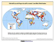
Federal
Global Multihazard Proportional Economic Loss Risk Deciles
National Aeronautics and Space Administration —
The Global Multihazard Proportional Economic Loss Risks is a 2.5 minute grid of a multihazard-based economic loss risk as a proportion of the economic productivity of... -
Federal
Global Multihazard Total Economic Loss Risk Deciles
National Aeronautics and Space Administration —
The Global Multihazard Total Economic Loss Risk Deciles is a 2.5 minute grid of global multihazard total economic loss risks. First, for each of the considered...

Official websites use .gov
A
.gov website belongs to an official government
organization in the United States.
Secure .gov websites use HTTPS
A
lock (
) or https:// means you’ve safely connected to
the .gov website. Share sensitive information only on official,
secure websites.