
-
Federal
SMAP L1B Radiometer Half-Orbit Time-Ordered Brightness Temperatures V006
National Aeronautics and Space Administration —
This Level-1B (L1B) product provides calibrated estimates of time-ordered geolocated brightness temperatures measured by the Soil Moisture Active Passive (SMAP)... -
Federal
AMSR-E/Aqua Daily L3 6.25 km 89 GHz Brightness Temperature Polar Grids V003
National Aeronautics and Space Administration —
This Level-3 gridded product (AE_SI6) includes brightness temperatures at 89.0 GHz. Data are mapped to a polar stereographic grid at 6.25 km spatial resolution. This... -
Federal
PALS/In Situ Multi-Campaign 800 m UTM Grid Brightness Temperature, Backscatter, and Soil Moisture Match-Up V001
National Aeronautics and Space Administration —
This data set contains data obtained by the Passive Active L- and S-band (PALS) microwave aircraft instrument that are matched up with a variety of soil moisture... -
Federal
SGP97 Upper Air: DOE ARM 50 MHz Profiler RASS
Department of Agriculture —
The Department of Energy (DOE) Atmospheric Radiation Measurement (ARM) Southern Great Plains (SGP) 50 MHz Radar Wind Profiler and Radio Acoustic Sounding System... -
Federal
TROPICS01 Pathfinder L1A Orbital Geolocated Native-Resolution Antenna Temperatures V1.0
National Aeronautics and Space Administration —
The "Time-Resolved Observations of Precipitation structure and storm Intensity with a Constellation of Smallsats" (TROPICS) mission has a goal of providing nearly... -
Federal
TROPICS05 L1A Orbital Geolocated Native-Resolution Antenna Temperatures V0.2
National Aeronautics and Space Administration —
The "Time-Resolved Observations of Precipitation structure and storm Intensity with a Constellation of Smallsats" (TROPICS) mission has a goal of providing nearly... -
Federal
AMSR-E/AMSR2 Unified L3 Daily 6.25 km Polar Gridded 89 GHz Brightness Temperatures V001
National Aeronautics and Space Administration —
This data set reports 6.25 km resolution, horizontally and vertically polarized average daily 89.0 GHz brightness temperatures for the Advanced Microwave Scanning... -
Federal
Sounder SIPS: AQUA AIRS IR + MW Level 2 CLIMCAPS: Cloud Cleared Radiances V2 at GES DISC
National Aeronautics and Space Administration —
The CLIMCAPS (Community Long-term Infrared Microwave Coupled Product System) algorithm is used to analyze data from the AIRS (Atmospheric Infrared Sounder) and AMSU... -
Federal
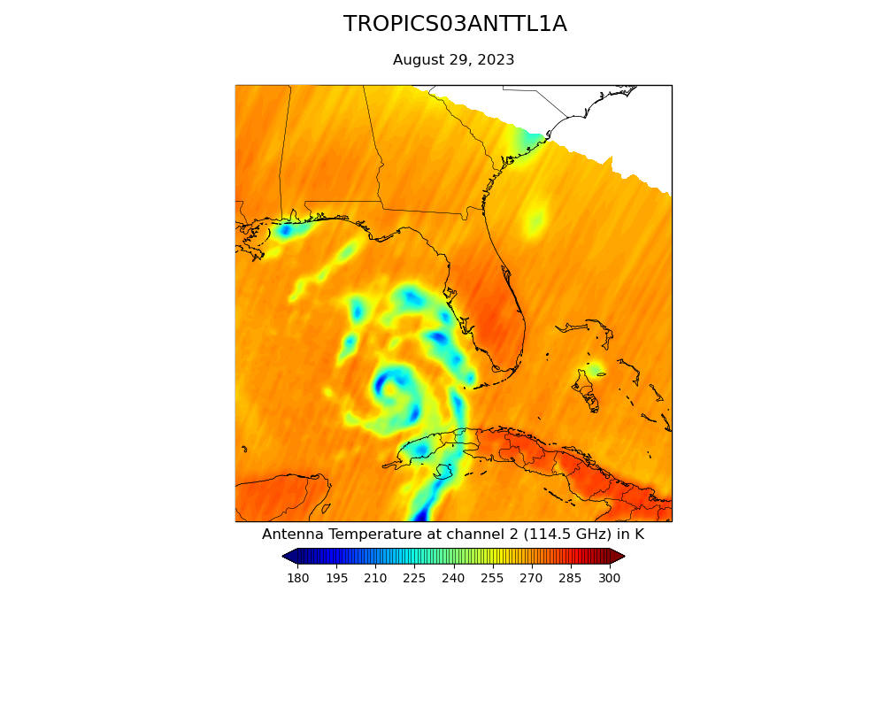
TROPICS03 L2A Unified Resolution Brightness Temperatures V1.0
National Aeronautics and Space Administration —
The "Time-Resolved Observations of Precipitation structure and storm Intensity with a Constellation of Smallsats" (TROPICS) mission has a goal of providing nearly... -
Federal
SMAPVEX16 Manitoba Radiometer Brightness Temperature Data V001
National Aeronautics and Space Administration —
This data set contains brightness temperatures obtained by in situ L-band radiometers. The data were collected for the Soil Moisture Active Passive Validation... -
Federal
AMSR-E/Aqua Daily L3 6.25 km Sea Ice Drift Polar Grids V001
National Aeronautics and Space Administration —
This product provides 6.25 km sea ice drift grids for the Northern and Southern Hemispheres. -
Federal
Soil Moisture Active Passive (SMAP) L4 Soil Moisture Ancillary LDAS Parameters Files V001
National Aeronautics and Space Administration —
This ancillary SMAP product contains three dynamic Land Data Assimilation Systems (LDAS) data sets. These data sets include Brightness Temperature (TB) scaling... -
Federal
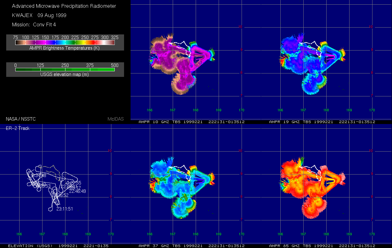
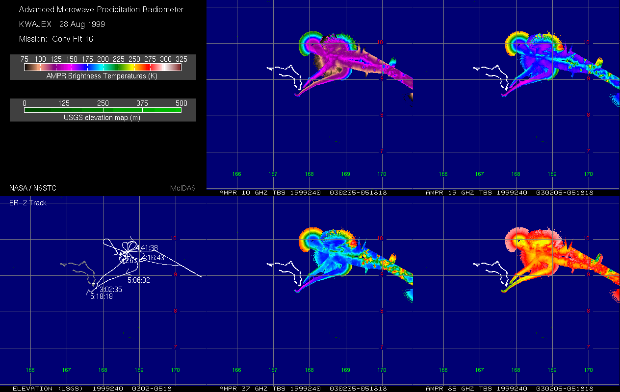
AMPR BRIGHTNESS TEMPERATURE (TB) KWAJEX V1
National Aeronautics and Space Administration —
The Advanced Microwave Precipitation Radiometer (AMPR) was deployed during the First Kwajelein Experiment (KWAJEX), which provided Ground Validation for instruments... -
Federal
TOVS GLA MONTHLY GRIDS from NOAA-10 V01 (TOVSAMNG) at GES DISC
National Aeronautics and Space Administration —
This dataset (TOVSAMNG) contains the TIROS Operational Vertical Sounder (TOVS) level 3 geophysical parameters derived using data from NOAA-10 and the physical... -
Federal
SMAPVEX15 PALS Soil Moisture Data V001
National Aeronautics and Space Administration —
This data set contains soil moisture data derived from the brightness temperatures measured by the Passive Active L-band System (PALS) microwave aircraft instrument.... -
Federal
SMAPVEX12 PALS Soil Moisture Data V001
National Aeronautics and Space Administration —
This data set contains soil moisture data obtained by the Passive Active L-band System (PALS) aircraft instrument. The data were collected as part of SMAPVEX12, the... -
Federal
TROPICS06 L2A Unified Resolution Brightness Temperatures V1.0
National Aeronautics and Space Administration —
The "Time-Resolved Observations of Precipitation structure and storm Intensity with a Constellation of Smallsats" (TROPICS) mission has a goal of providing nearly... -
Federal
GPM GROUND VALIDATION ENVIRONMENT CANADA (EC) PASSIVE MICROWAVE RADIOMETER AND SOIL MOISTURE-TEMPERATURE DATA GCPEX V1
National Aeronautics and Space Administration —
The GPM Ground Validation Environment Canada (EC) Passive Microwave Radiometer and Soil Moisture-Temperature Data GCPEx dataset is consisted of data during the GPM... -
Federal
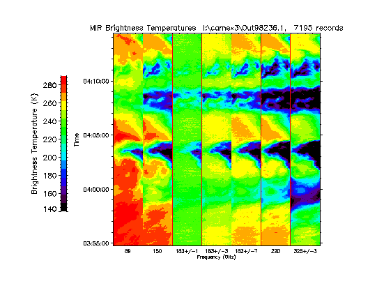
CAMEX-3 ER-2 Millimeter-wave Imaging Radiometer (MIR) V1
National Aeronautics and Space Administration —
The CAMEX-3 ER-2 Millimeter-wave Imaging Radiometer (MIR) dataset is a browse-only dataset containing plots of brightness temperature measurements collected by the... -
Federal
TROPICS03 L2B Atmospheric Vertical Temperature and Moisture Profiles (AVTP, AVMP) V1.0
National Aeronautics and Space Administration —
The "Time-Resolved Observations of Precipitation structure and storm Intensity with a Constellation of Smallsats" (TROPICS) mission has a goal of providing nearly...

Official websites use .gov
A
.gov website belongs to an official government
organization in the United States.
Secure .gov websites use HTTPS
A
lock (
) or https:// means you’ve safely connected to
the .gov website. Share sensitive information only on official,
secure websites.